
File:Balkans925.png
Size of this preview: 468 × 600 pixels. Other resolutions: 187 × 240 pixels | 472 × 605 pixels.
Original file (472 × 605 pixels, file size: 225 KB, MIME type: image/png)
| This is a file from the Wikimedia Commons. Information from its description page there is shown below. Commons is a freely licensed media file repository. You can help. |
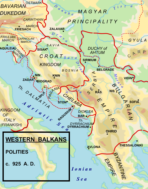
| Description |
English: Political map of the western Balkan in 925 AD. |
||
| Date | |||
| Source |
Made by Hxseek using the following sources:
|
||
| Author | Hxseek at English Wikipedia | ||
| Permission (Reusing this file) |
|
Original upload log
The original description page was here. All following user names refer to en.wikipedia.
- 2009-02-07 03:00 Hxseek 472×605× (230158 bytes) NEW FORMAT
- 2009-02-01 07:34 Hxseek 513×440× (484610 bytes)
File history
Click on a date/time to view the file as it appeared at that time.
| Date/Time | Thumbnail | Dimensions | User | Comment | |
|---|---|---|---|---|---|
| current | 18:07, 25 May 2022 | | 472 × 605 (225 KB) | Luigimini | Bosnia did not exist. It is simply FALSE! Stop putting false maps. |
| 16:15, 4 April 2022 |  | 472 × 605 (273 KB) | Sadko | Reverted to version as of 14:50, 21 July 2021 (UTC) per sources and previously posted refs. | |
| 18:27, 18 February 2022 |  | 472 × 605 (225 KB) | Luigimini | Bosnia is first mentioned in 948. | |
| 14:50, 21 July 2021 |  | 472 × 605 (273 KB) | Santasa99 | Reverted to version as of 14:25, 27 November 2015 (UTC) the last ver. reasonably explained by Spiridon Ion with ref's | |
| 20:03, 8 February 2020 |  | 472 × 605 (275 KB) | Mhare | The map is referenced by multiple sources (see description) | |
| 16:38, 19 October 2016 |  | 472 × 605 (275 KB) | Julieta39 | Too bad to lose the details & rectifications from the Westermann Atlas just for a single graphic error, easily corrected. | |
| 13:02, 23 March 2016 |  | 472 × 605 (225 KB) | Ceha | Reverted to version as of 19:24, 5 March 2009 (UTC) .. there is no Bosnia in that time | |
| 14:25, 27 November 2015 |  | 472 × 605 (273 KB) | Spiridon Ion Cepleanu | Idem, continuation | |
| 10:15, 27 November 2015 |  | 472 × 605 (261 KB) | Spiridon Ion Cepleanu | Little changes : dalmatian Theme & other borders according with « Grosser Atlas zur Weltgeschichte » (H.E.Stier, dir.) Westermann 1985, ISBN 3-14-100919-8. | |
| 10:03, 27 November 2015 |  | 472 × 605 (261 KB) | Spiridon Ion Cepleanu | Little changes : dalmatian Theme & other borders according with « Grosser Atlas zur Weltgeschichte » (H.E.Stier, dir.) Westermann 1985, ISBN 3-14-100919-8. |
File usage
The following pages on the English Wikipedia use this file (pages on other projects are not listed):
- 926
- Battle of Drava River
- Bulgarian–Serbian wars (medieval)
- Croatia
- Croatian–Bulgarian battle of 926
- Dalmatia (theme)
- Michael of Zahumlje
- Serbia in the Middle Ages
- Tomislav of Croatia
- Zachlumia
- Zaharija of Serbia
- User:Slovenski Volk
- User:Zoupan/Zachumlia
- Wikipedia:Reliable sources/Noticeboard/Archive 32
- Portal:Croatia
Global file usage
The following other wikis use this file:
- Usage on an.wikipedia.org
- Usage on ar.wikipedia.org
- Usage on arz.wikipedia.org
- Usage on be.wikipedia.org
- Usage on bg.wikipedia.org
- Usage on bs.wikipedia.org
- Usage on ca.wikipedia.org
- Usage on de.wikipedia.org
- Usage on de.wikibooks.org
- Usage on el.wikipedia.org
- Usage on eo.wikipedia.org
- Usage on es.wikipedia.org
- Usage on fi.wikipedia.org
- Usage on fr.wikipedia.org
- Usage on gl.wikipedia.org
- Usage on hr.wikipedia.org
- Usage on hy.wikipedia.org
- Usage on it.wikipedia.org
- Usage on ka.wikipedia.org
- Usage on ku.wikipedia.org
- Usage on lt.wikipedia.org
- Usage on mk.wikipedia.org
- Usage on pl.wikipedia.org
- Usage on pt.wikipedia.org
- Usage on ro.wikipedia.org
View more global usage of this file.