
File:Bike trail using former railway trestle and swing bridge over Lake Coeur d'Alene.jpg

Size of this preview: 800 × 397 pixels. Other resolutions: 320 × 159 pixels | 640 × 318 pixels | 1,024 × 508 pixels | 1,280 × 636 pixels | 2,560 × 1,271 pixels | 5,184 × 2,574 pixels.
Original file (5,184 × 2,574 pixels, file size: 3.18 MB, MIME type: image/jpeg)
| This is a file from the Wikimedia Commons. Information from its description page there is shown below. Commons is a freely licensed media file repository. You can help. |
Summary
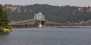
| Description | The Trail of the Coeur d'Alenes uses a 3,100-foot former railroad trestle to cross Lake Coeur d'Alene (also known as Lake Chatcolet in this section). It includes a 1921 swing bridge which was permanently raised up in elevation during the project to create a trail along the former railroad line, to keep a navigation channel open for taller boats while eliminating the need for the swing span ever to open. The original, flat level of the trestle can still be easily discerned in this photo, taken from the lake's west shore. |
| Date | |
| Source | _MG_7746 |
| Author | Nikky from Seattle, USA |
| Other versions |
.jpg) |
| Camera location | | View this and other nearby images on: OpenStreetMap |
|---|
Licensing
This file is licensed under the Creative Commons Attribution 2.0 Generic license.
- You are free:
- to share – to copy, distribute and transmit the work
- to remix – to adapt the work
- Under the following conditions:
- attribution – You must give appropriate credit, provide a link to the license, and indicate if changes were made. You may do so in any reasonable manner, but not in any way that suggests the licensor endorses you or your use.
| This image was originally posted to Flickr by allynfolksjr at https://flickr.com/photos/8070778@N02/10009296736. It was reviewed on 11 April 2017 by FlickreviewR and was confirmed to be licensed under the terms of the cc-by-2.0. |
File history
Click on a date/time to view the file as it appeared at that time.
| Date/Time | Thumbnail | Dimensions | User | Comment | |
|---|---|---|---|---|---|
| current | 07:07, 11 April 2017 | | 5,184 × 2,574 (3.18 MB) | Steve Morgan | =={{int:filedesc}}== {{Information |Description=The Trail of the Coeur d'Alenes uses a 3,100-foot former railroad trestle to cross Lake Coeur d'Alene (also known as Lake Chatcolet in this section). It includes a 192... |
File usage
The following pages on the English Wikipedia use this file (pages on other projects are not listed):