
File:Branson Airport 9-26-009 by KTrimble.jpg

Size of this preview: 800 × 531 pixels. Other resolutions: 320 × 213 pixels | 640 × 425 pixels | 1,072 × 712 pixels.
Original file (1,072 × 712 pixels, file size: 210 KB, MIME type: image/jpeg)
| This is a file from the Wikimedia Commons. Information from its description page there is shown below. Commons is a freely licensed media file repository. You can help. |
Summary
| Description |
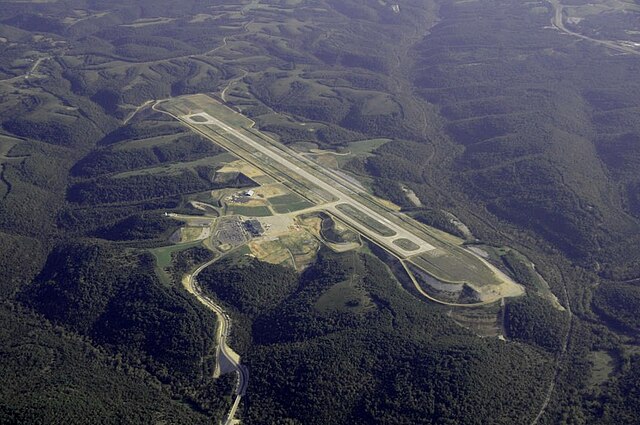
English: Aerial Photo of Branson Airport near Branson Missouri from about 7000 ft msl (about 5700 ft over ground)
Deutsch: Luftbild des Flughafen Branson in Missouri (USA) aus etwa 2133 m über Meeresspiegel (etwa 1736 m über Grund) |
| Date | |
| Source | Original uploaded on en.wikipedia. Photographedand minor adjustments for contrast etc by KTrimble |
| Author | Kelly Trimble |
| Object location | | View this and other nearby images on: OpenStreetMap |
|---|
Licensing
| I, the copyright holder of this work, release this work into the public domain. This applies worldwide. In some countries this may not be legally possible; if so: I grant anyone the right to use this work for any purpose, without any conditions, unless such conditions are required by law. |
Original upload log
The original description page was here. All following user names refer to en.wikipedia.
Upload date | User | Bytes | Dimensions | Comment
- 2009-09-28 03:23:09 | KTrimble | 215176 | 1072×712 | {{Information |Description = Aerial Photo of Branson Airport near Branson Missouri from 7000 msl 9-26-009 minor adjustments for contrast etc |Source = I KTrimble created this work entirely by myself. |Date = 9-26-2009 |Author
File history
Click on a date/time to view the file as it appeared at that time.
| Date/Time | Thumbnail | Dimensions | User | Comment | |
|---|---|---|---|---|---|
| current | 17:34, 31 May 2010 | | 1,072 × 712 (210 KB) | Saibo | == {{int:filedesc}} == {{Information |description={{en|Aerial Photo of Branson Airport near Branson Missouri from 7000 msl 9-26-2009}} |date=2009-09-26 |source=Original uploaded on en.wikipedia. Photographedand minor adjustments for contrast etc by [[:en |
File usage
The following pages on the English Wikipedia use this file (pages on other projects are not listed):
Global file usage
The following other wikis use this file:
- Usage on arz.wikipedia.org
- Usage on ceb.wikipedia.org
- Usage on de.wikipedia.org
- Usage on es.wikipedia.org
- Usage on fa.wikipedia.org
- Usage on no.wikipedia.org
- Usage on tg.wikipedia.org
- Usage on ur.wikipedia.org
- Usage on www.wikidata.org