
File:CH-NB Photoglob-Wehrli EAD-WEHR-32043-B.tiff

Original file (4,642 × 3,471 pixels, file size: 15.4 MB, MIME type: image/tiff)
| This is a file from the Wikimedia Commons. Information from its description page there is shown below. Commons is a freely licensed media file repository. You can help. |
Summary
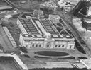
| Kairo, Landschaft
( |
|||||||||||||||||||||||||||
|---|---|---|---|---|---|---|---|---|---|---|---|---|---|---|---|---|---|---|---|---|---|---|---|---|---|---|---|
| Photographer |
|
||||||||||||||||||||||||||
| Title |
Kairo, Landschaft |
||||||||||||||||||||||||||
| Description |
Aegypten, Kairo und Nil aus ca. 500 m Höhe, Ballonaufnahme |
||||||||||||||||||||||||||
| Depicted place | Kairo | ||||||||||||||||||||||||||
| Date | 1904 | ||||||||||||||||||||||||||
| Medium | photograph | ||||||||||||||||||||||||||
| Dimensions | height: 18 cm (7 in); width: 24 cm (9.4 in) | ||||||||||||||||||||||||||
| Collection |
|
||||||||||||||||||||||||||
| Current location |
Prints and Drawings Department, Federal Archives of historic monuments |
||||||||||||||||||||||||||
| Accession number |
EAD-WEHR-32043-B |
||||||||||||||||||||||||||
| Notes | Published by Wehrli AG (1904-1924) [GND-ID 16137188-7] | ||||||||||||||||||||||||||
| Source | https://www.helveticarchives.ch/detail.aspx?id=162814 | ||||||||||||||||||||||||||
| Permission (Reusing this file) |
|
||||||||||||||||||||||||||
| Other versions | |||||||||||||||||||||||||||
.jpg)


| Camera location | | View this and other nearby images on: OpenStreetMap |
|---|
Licensing
|
The author died in 1931, so this work is in the public domain in its country of origin and other countries and areas where the copyright term is the author's life plus 80 years or fewer. This work is in the public domain in the United States because it was published (or registered with the U.S. Copyright Office) before January 1, 1929. | |
| This file has been identified as being free of known restrictions under copyright law, including all related and neighboring rights. | |
File history
Click on a date/time to view the file as it appeared at that time.
| Date/Time | Thumbnail | Dimensions | User | Comment | |
|---|---|---|---|---|---|
| current | 09:11, 22 May 2014 |  | 4,642 × 3,471 (15.4 MB) | Swiss National Library | {{Information |Description ={{en|1=tmp}} |Source =tmp |Author =tmp |Date = |Permission = |other_versions = }} |
File usage
Global file usage
The following other wikis use this file:
- Usage on ar.wikipedia.org
- Usage on bn.wikipedia.org
- Usage on de.wikipedia.org
- Usage on eo.wikipedia.org
- Usage on fr.wikipedia.org
- Usage on hy.wikipedia.org
- Usage on ig.wikipedia.org
- Usage on it.wikipedia.org
- Usage on la.wikipedia.org
- Usage on pnb.wikipedia.org
- Usage on si.wikipedia.org
- Usage on sl.wikipedia.org
- Usage on tl.wikipedia.org
- Usage on ur.wikipedia.org
- Usage on vi.wikipedia.org
- Usage on zh.wikipedia.org