
File:Cerrado ecoregion.jpg
No higher resolution available.
Cerrado_ecoregion.jpg (400 × 300 pixels, file size: 100 KB, MIME type: image/jpeg)
| This is a file from the Wikimedia Commons. Information from its description page there is shown below. Commons is a freely licensed media file repository. You can help. |
Summary
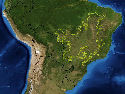
| Description | This is a map showing the location of the Cerrado ecoregion as delineated by the World Wide Fund for Nature. I, Pfly, made it using NASA Blue Marble imagery and ecoregion GIS data which I simplified and digitized in Photoshop. |
| Date | |
| Source | NASA, plus my additions by myself. |
| Author | Pfly |
Licensing
| This file is in the public domain in the United States because it was solely created by NASA. NASA copyright policy states that "NASA material is not protected by copyright unless noted". (See Template:PD-USGov, NASA copyright policy page or JPL Image Use Policy.) | ||
 |
Warnings:
|
File history
Click on a date/time to view the file as it appeared at that time.
| Date/Time | Thumbnail | Dimensions | User | Comment | |
|---|---|---|---|---|---|
| current | 05:36, 18 January 2007 | | 400 × 300 (100 KB) | Pfly | {{Information |Description=This is a map showing the location of the Cerrado ecoregion as delineated by the World Wide Fund for Nature. I, Pfly, made it using NASA Blue Marb |
File usage
The following pages on the English Wikipedia use this file (pages on other projects are not listed):
Global file usage
The following other wikis use this file:
- Usage on ar.wikipedia.org
- Usage on ast.wikipedia.org
- Usage on azb.wikipedia.org
- Usage on bg.wikipedia.org
- Usage on ca.wikipedia.org
- Usage on ceb.wikipedia.org
- Usage on cs.wikipedia.org
- Usage on de.wikipedia.org
- Usage on en.wiktionary.org
- Usage on eo.wikipedia.org
- Usage on es.wikipedia.org
- Usage on fi.wikipedia.org
- Usage on fr.wikipedia.org
- Usage on gl.wikipedia.org
- Usage on he.wikipedia.org
- Usage on hr.wikipedia.org
- Usage on hu.wikipedia.org
- Usage on it.wikipedia.org
- Usage on ml.wikipedia.org
- Usage on nl.wikipedia.org
- Usage on no.wikipedia.org
- Usage on pl.wikipedia.org
- Usage on pt.wikipedia.org
- Cerrado
- Vegetação do Brasil
- Hypocephalus armatus
- Polinizadores do cerrado
- Usuário(a):Casadopovo/Eurafrica
- Wikipédia:Wiki Loves Monuments 2019/Brasil/Lista/Tocantins
- Wikipédia:Wiki Loves Monuments 2019/Brasil/Lista/Bahia
- Wikipédia:Wiki Loves Monuments 2019/Brasil/Lista/Maranhão
- Wikipédia:Wiki Loves Monuments 2019/Brasil/Lista/Distrito Federal
View more global usage of this file.