
File:Chetco Bar Fire, 19 August 2017, MODIS Terra visible Moderate-resolution imaging spectroradiometer satellite image.tif

Size of this JPG preview of this TIF file: 800 × 425 pixels. Other resolutions: 320 × 170 pixels | 640 × 340 pixels | 1,024 × 544 pixels | 1,920 × 1,020 pixels.
Original file (1,920 × 1,020 pixels, file size: 5.61 MB, MIME type: image/tiff)
| This is a file from the Wikimedia Commons. Information from its description page there is shown below. Commons is a freely licensed media file repository. You can help. |
Summary
| Description |
English: Chetco Bar Fire in Brookings effect wind on August 19, 2017, MODIS Terra visible Moderate-resolution imaging spectroradiometer satellite image |
| Date | |
| Source | https://worldview.earthdata.nasa.gov/ |
| Author | NASA |
| Camera location | | View this and other nearby images on: OpenStreetMap |
|---|
Data source: https://worldview.earthdata.nasa.gov/
Licensing
| This file is in the public domain in the United States because it was solely created by NASA. NASA copyright policy states that "NASA material is not protected by copyright unless noted". (See Template:PD-USGov, NASA copyright policy page or JPL Image Use Policy.) | ||
 |
Warnings:
|
File history
Click on a date/time to view the file as it appeared at that time.
| Date/Time | Thumbnail | Dimensions | User | Comment | |
|---|---|---|---|---|---|
| current | 01:17, 5 January 2018 | 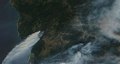 | 1,920 × 1,020 (5.61 MB) | Erthygy | User created page with UploadWizard |
File usage
The following pages on the English Wikipedia use this file (pages on other projects are not listed):
Global file usage
The following other wikis use this file:
- Usage on vi.wikipedia.org