
File:Cumberland Plateau in NW Georgia.jpg

Size of this preview: 800 × 600 pixels. Other resolutions: 320 × 240 pixels | 640 × 480 pixels | 1,024 × 768 pixels | 1,200 × 900 pixels.
Original file (1,200 × 900 pixels, file size: 584 KB, MIME type: image/jpeg)
| This is a file from the Wikimedia Commons. Information from its description page there is shown below. Commons is a freely licensed media file repository. You can help. |
Summary
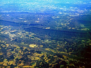
| Description | Aerial view of the southern margin of the Cumberland Plateau in NW Georgia. In the lower left there is a tiny portion of the top plateau of Sand Mountain. Above that is a portion of the Lookout Creek valley with the town of Trenton, Georgia, and the Interstate 59. Further up, in about the middle third of the picture there are the steep flanks and the top plateau of the northern portion of Lookout Mountain whose northern tip is at Chattanooga, Tennessee (far outside the left margin of the picture). |
| Date | 31 December 2004 (original upload date) |
| Source | Transferred from en.wikipedia to Commons by Ævar Arnfjörð Bjarmason. |
| Author | The original uploader was Pollinator at English Wikipedia. |
| Camera location | | View this and other nearby images on: OpenStreetMap |
|---|
Licensing
| This file is licensed under the Creative Commons Attribution-Share Alike 3.0 Unported license. Subject to disclaimers. | ||
| ||
| This licensing tag was added to this file as part of the GFDL licensing update. |

|
Permission is granted to copy, distribute and/or modify this document under the terms of the GNU Free Documentation License, Version 1.2 or any later version published by the Free Software Foundation; with no Invariant Sections, no Front-Cover Texts, and no Back-Cover Texts. A copy of the license is included in the section entitled GNU Free Documentation License. Subject to disclaimers. |
History on English Wikipedia
- (Delete all revisions of this file) (cur) 17:04, 11 March 2005 . . Naturenet (Talk | contribs | block) . . 1200×900 (598,370 bytes) (Edited version)
- (del) (rev) 09:06, 31 December 2004 . . Pollinator (Talk | contribs | block) . . 1200×900 (1,214,316 bytes) (Cuesta Cumberland Plateau Tennessee)
- (del) (rev) 07:11, 31 December 2004 . . Pollinator (Talk | contribs | block) . . 1200×900 (599,404 bytes) (cuesta Cumberland Plateau Tennessee)
Note: The file description in the second (and several following) version(s) of this commons file page included the comment: “Edited to improve contrast Naturenet 13:05, 11 Mar 2005 (UTC)” This may refer to the youngest edit listed in the orignal file history above, although it is unclear where the 4-hours discrepancy comes from.
| Annotations | This image is annotated: View the annotations at Commons |
File history
Click on a date/time to view the file as it appeared at that time.
| Date/Time | Thumbnail | Dimensions | User | Comment | |
|---|---|---|---|---|---|
| current | 06:46, 26 October 2005 | | 1,200 × 900 (584 KB) | Ævar Arnfjörð Bjarmason | Escarpment on the Cumberland Plateau, Tennessee by Pollinator. Category:Escarpments |
File usage
No pages on the English Wikipedia use this file (pages on other projects are not listed).
Global file usage
The following other wikis use this file:
- Usage on de.wikipedia.org
- Usage on es.wikipedia.org
- Usage on fa.wikipedia.org
- Usage on hu.wikipedia.org
- Usage on is.wikipedia.org
- Usage on ja.wikipedia.org
- Usage on ka.wikipedia.org
- Usage on ko.wikipedia.org