
File:Federation Square (5399921791).jpg

Original file (4,288 × 2,848 pixels, file size: 2.98 MB, MIME type: image/jpeg)
| This is a file from the Wikimedia Commons. Information from its description page there is shown below. Commons is a freely licensed media file repository. You can help. |
.jpg)
Summary
| Description |
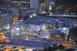
Federation Square (also colloquially contracted to Fed Square) is a civic centre and cultural precinct in the city of Melbourne, Victoria, Australia. It is a mixed-use development covering an area of 3.2 hectare and centred around two major public spaces, open squares (St. Paul's Court and The Square) and one covered (The Atrium) built on top of a concrete deck over busy railway lines and was opened in 2002. It is Victoria’s second most popular tourist attraction, attracting 8.41 million visitors in 2009. Its design has caused much controversy since its first planning and continued to divide opinion after its opening. Despite this, the precinct continues to expand. Unlike many Australian landmarks, it was not opened by the Queen, nor was she invited to its unveiling [Wikipedia.org] |
| Date | |
| Source | Federation Square |
| Author | Jorge Láscar from Australia |
| Camera location | | View this and other nearby images on: OpenStreetMap |
|---|
.jpg¶ms=-37.817699_N_0144.969101_E_globe:Earth_type:camera_source:Flickr_&language=en)
Licensing
- You are free:
- to share – to copy, distribute and transmit the work
- to remix – to adapt the work
- Under the following conditions:
- attribution – You must give appropriate credit, provide a link to the license, and indicate if changes were made. You may do so in any reasonable manner, but not in any way that suggests the licensor endorses you or your use.
| This image was originally posted to Flickr by Jorge Lascar at https://www.flickr.com/photos/8721758@N06/5399921791. It was reviewed on 2 April 2014 by FlickreviewR and was confirmed to be licensed under the terms of the cc-by-2.0. |
File history
Click on a date/time to view the file as it appeared at that time.
| Date/Time | Thumbnail | Dimensions | User | Comment | |
|---|---|---|---|---|---|
| current | 07:46, 2 April 2014 | | 4,288 × 2,848 (2.98 MB) | Russavia | Transferred from Flickr |
File usage
Global file usage
The following other wikis use this file:
- Usage on he.wikipedia.org
- Usage on lt.wikipedia.org
- Usage on zh.wikipedia.org
.jpg)