
File:Flotillagazamapa.svg

Size of this PNG preview of this SVG file: 783 × 600 pixels. Other resolutions: 314 × 240 pixels | 627 × 480 pixels | 1,003 × 768 pixels | 1,280 × 980 pixels | 2,560 × 1,960 pixels | 1,148 × 879 pixels.
Original file (SVG file, nominally 1,148 × 879 pixels, file size: 815 KB)
| This is a file from the Wikimedia Commons. Information from its description page there is shown below. Commons is a freely licensed media file repository. You can help. |
Summary
| Description |
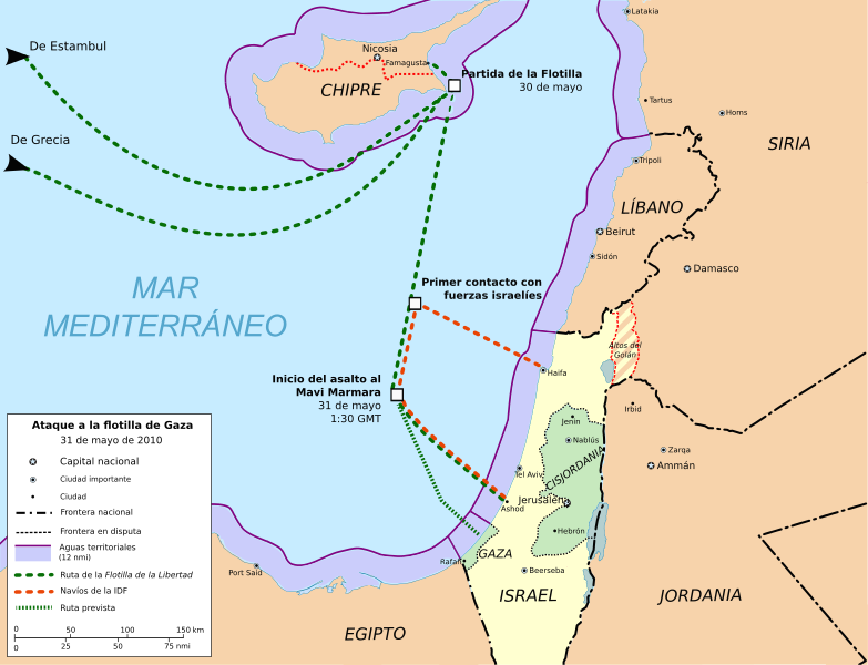
English: Freedom Flotilla incident. 31 may 2010.
Cartographic base from Open Street Maps (heavily modified) Flotilla route points from Freegaza.org (under CC by-sa)Español: Ataque a la Flotilla Libertad (ó Flotilla de Gaza) el 31 de mayo de 2010.
Base cartográfica de Open Street Maps (muy modificada) Puntos de la ruta de la Flotilla Freegaza.org (bajo licencia CC by-sa) |
| Date | |
| Source | Own work |
| Author | Montgomery |
| Other versions |
Derivative works of this file: Gaza flotilla raid map.svg  |
Geographic limits of the map:
- N 35.66° N
- S 30.47° N
- W 29.92° E
- E 38.01° E
Scale (full extent image) 1:3.500.000
Licensing
I, the copyright holder of this work, hereby publish it under the following licenses:

|
Permission is granted to copy, distribute and/or modify this document under the terms of the GNU Free Documentation License, Version 1.2 or any later version published by the Free Software Foundation; with no Invariant Sections, no Front-Cover Texts, and no Back-Cover Texts. A copy of the license is included in the section entitled GNU Free Documentation License. |
This file is licensed under the Creative Commons Attribution-Share Alike 4.0 International, 3.0 Unported, 2.5 Generic, 2.0 Generic and 1.0 Generic license.
- You are free:
- to share – to copy, distribute and transmit the work
- to remix – to adapt the work
- Under the following conditions:
- attribution – You must give appropriate credit, provide a link to the license, and indicate if changes were made. You may do so in any reasonable manner, but not in any way that suggests the licensor endorses you or your use.
- share alike – If you remix, transform, or build upon the material, you must distribute your contributions under the same or compatible license as the original.
You may select the license of your choice.
File history
Click on a date/time to view the file as it appeared at that time.
| Date/Time | Thumbnail | Dimensions | User | Comment | |
|---|---|---|---|---|---|
| current | 08:36, 14 November 2012 | | 1,148 × 879 (815 KB) | Kalgaron | FALSE, unless you can supply sources that indicate the flotilla was not headed for Gaza |
| 22:28, 30 June 2011 |  | 1,148 × 879 (818 KB) | Randam | Correction according to flotilla site | |
| 22:47, 15 June 2010 |  | 1,148 × 879 (815 KB) | Montgomery | Golan Heights (Altos del Golán) painted with stripes. Hour adjust. | |
| 13:59, 10 June 2010 |  | 1,148 × 879 (814 KB) | Montgomery | Adjust of territorial waters limits. Exclude contiguous zone. | |
| 23:28, 9 June 2010 |  | 1,148 × 879 (826 KB) | Montgomery | Map colours conventions & minor changes. | |
| 14:40, 7 June 2010 |  | 1,148 × 879 (917 KB) | Montgomery | minor changes | |
| 13:01, 7 June 2010 |  | 1,148 × 879 (1,023 KB) | Rastrojo | fixing | |
| 20:32, 6 June 2010 |  | 1,148 × 879 (1,016 KB) | Montgomery | {{Information |Description={{en|1=Freedom Flotilla incident. 31 may 2010. Cartographic base from Open Street Maps (heavily modified) Flotilla route points from [http://www.witnessgaza.com/ Freegaza.org] (under CC by-sa)}} {{es|1=Ataque a la Flotilla Liber |
File usage
No pages on the English Wikipedia use this file (pages on other projects are not listed).
Global file usage
The following other wikis use this file:
- Usage on ast.wikipedia.org
- Usage on ca.wikipedia.org
- Usage on cs.wikipedia.org
- Usage on cy.wikipedia.org
- Usage on es.wikipedia.org
- Usage on eu.wikipedia.org
- Usage on fr.wikipedia.org
- Usage on he.wikipedia.org
- Usage on ms.wikipedia.org
- Usage on pl.wikipedia.org
- Usage on pt.wikipedia.org
- Usage on th.wikipedia.org
- Usage on www.wikidata.org