
File:H-GAC.png
No higher resolution available.
H-GAC.png (300 × 278 pixels, file size: 27 KB, MIME type: image/png)
| This is a file from the Wikimedia Commons. Information from its description page there is shown below. Commons is a freely licensed media file repository. You can help. |

|
This locator map image could be re-created using vector graphics as an SVG file. This has several advantages; see Commons:Media for cleanup for more information. If an SVG form of this image is available, please upload it and afterwards replace this template with
{{vector version available|new image name}}.
It is recommended to name the SVG file “H-GAC.svg”—then the template Vector version available (or Vva) does not need the new image name parameter. |
Summary
| Description |
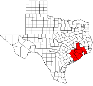
English: Map of Texas highlighting counties served by the Houston-Galveston Area Council; created by User:Acntx. |
| Date | 2 July 2006 (original upload date) |
| Source | Own work |
| Author | Acntx at English Wikipedia |
Licensing
Acntx at English Wikipedia, the copyright holder of this work, hereby publishes it under the following license:
| This file is licensed under the Creative Commons Attribution-Share Alike 3.0 Unported license. Subject to disclaimers. | ||
| Attribution: Acntx at English Wikipedia | ||
| ||
| This licensing tag was added to this file as part of the GFDL licensing update. |

|
Permission is granted to copy, distribute and/or modify this document under the terms of the GNU Free Documentation License, Version 1.2 or any later version published by the Free Software Foundation; with no Invariant Sections, no Front-Cover Texts, and no Back-Cover Texts. A copy of the license is included in the section entitled GNU Free Documentation License. Subject to disclaimers. |
Original upload log
The original description page was here. All following user names refer to en.wikipedia.
- 2006-07-02 23:05 Acntx 300×278 (28016 bytes) Map of Texas highlighting counties served by the Houston-Galveston Area Council; created by [[User:Acntx]]. {{GDFL}}
File history
Click on a date/time to view the file as it appeared at that time.
| Date/Time | Thumbnail | Dimensions | User | Comment | |
|---|---|---|---|---|---|
| current | 21:10, 12 July 2012 | | 300 × 278 (27 KB) | MGA73bot2 | {{BotMoveToCommons|en.wikipedia|year={{subst:CURRENTYEAR}}|month={{subst:CURRENTMONTHNAME}}|day={{subst:CURRENTDAY}}}} == {{int:filedesc}} == {{Information |description={{en|1=Map of Texas highlighting counties served by the Houston-Galveston Area Cou... |
File usage
The following pages on the English Wikipedia use this file (pages on other projects are not listed):