Jump to content

File:Hamburgs Bahnhöfe1880.png

Page contents not supported in other languages.
This is a file from the Wikimedia Commons
From Wikipedia, the free encyclopedia

Original file(2,097 × 1,804 pixels, file size: 9.16 MB, MIME type: image/png)

Summary

Description
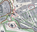
English: Maps of the stations of Hamburg in and from 1880, incuding the communication lines, partly in streets
Deutsch: Karte der Bahnhöfe Hamburgs 1880 mit den teilweise auf Straßen geführten Verbindungsbahnen.
blau = Berliner Bahnhof
grün = Bahnhof Klostertor
pink = Lübecker Bahnhof
rot = Venlo-Hamburger Bahnhof
Date
Source http://www.christian-terstegge.de/hamburg/karten_hamburg/files/1880_gaedechens_300dpi.jpeg
Author
Cipriano Francisco Gaedechens  (1818–1901)  wikidata:Q1092745 s:de:Cipriano Francisco Gaedechens
 
Cipriano Francisco Gaedechens
Description German politician, writer and numismatist
Date of birth/death 1 April 1818 Edit this at Wikidata 22 January 1901 Edit this at Wikidata
Location of birth/death Hamburg Hamburg
Work location
Authority file
creator QS:P170,Q1092745
: Historische Topographie der Freien und Hansestadt Hamburg..., 1880, edited by User:Ulamm
Other versions This is a cut of File:Hamburg1880Gaedechens.jpeg

Cut and upload by Ulamm (talk) 16:37, 19 December 2010 (UTC)

Licensing

Public domain

This work is in the public domain in its country of origin and other countries and areas where the copyright term is the author's life plus 70 years or fewer.


You must also include a United States public domain tag to indicate why this work is in the public domain in the United States.

Captions

Add a one-line explanation of what this file represents

Items portrayed in this file

depicts

File history

Click on a date/time to view the file as it appeared at that time.

Date/TimeThumbnailDimensionsUserComment
current17:06, 19 December 2010Thumbnail for version as of 17:06, 19 December 20102,097 × 1,804 (9.16 MB)UlammMarks in various colours
17:00, 19 December 2010Thumbnail for version as of 17:00, 19 December 20102,097 × 1,804 (9.16 MB)UlammMarks in various colours
16:44, 19 December 2010Thumbnail for version as of 16:44, 19 December 20102,097 × 1,804 (9.16 MB)UlammStations marked with red rings
16:37, 19 December 2010Thumbnail for version as of 16:37, 19 December 20102,097 × 1,804 (9.2 MB)Ulamm{{Information |Description={{en|1=Maps of the stations of Hamburg in and from 1880, incuding the communication lines, partly in streets}} {{de|1=Karte der Bahnhöfe Hamburgs 1880 mit den teilweise auf Straßen geführten Verbindungsbahnen.}} |Source=http:
No pages on the English Wikipedia use this file (pages on other projects are not listed).

Global file usage

The following other wikis use this file: