
File:Hammond Slides КПСС.jpg

Size of this preview: 800 × 518 pixels. Other resolutions: 320 × 207 pixels | 640 × 414 pixels | 1,024 × 663 pixels | 1,280 × 828 pixels | 2,560 × 1,656 pixels | 10,199 × 6,599 pixels.
Original file (10,199 × 6,599 pixels, file size: 3.76 MB, MIME type: image/jpeg)
| This is a file from the Wikimedia Commons. Information from its description page there is shown below. Commons is a freely licensed media file repository. You can help. |
| Warning | The original file is very high-resolution. It might not load properly or could cause your browser to freeze when opened at full size. |
|---|
Summary
| Description |
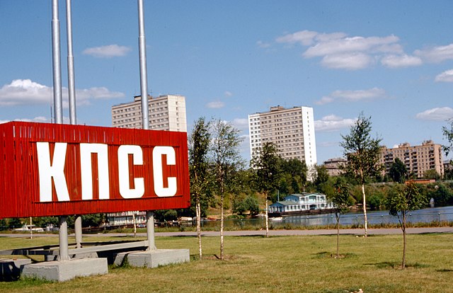
English: These files are unlabeled, but they were taken by Thomas T. Hammond during his travels in the Soviet Union, probably in 1975. This specific image features a Soviet neighborhood with a large sign promoting the Communist Party of the Soviet Union. // Location: Moscow, Kozhukhovsky Bay of the Moskva River, photographed from Andropova prospekt looking norht-east into Trofimova Street Русский: 1975 год. Москва. Вид с Пролетарского проспекта (ныне Андропова) на северо-восток, через Кожуховский затон в сторону улицы Трофимова |
| Date | |
| Source | University of Virginia Center for Russian, East European, and Eurasian Studies (www.virginia.edu/creees) |
| Author | Thomas Taylor Hammond (1920-1993) |
| Permission (Reusing this file) |
| Camera location | | View this and other nearby images on: OpenStreetMap |
|---|
| Object location | | View this and other nearby images on: OpenStreetMap |
|---|
Licensing
I, the copyright holder of this work, hereby publish it under the following license:
This file is licensed under the Creative Commons Attribution-Share Alike 4.0 International license.
- You are free:
- to share – to copy, distribute and transmit the work
- to remix – to adapt the work
- Under the following conditions:
- attribution – You must give appropriate credit, provide a link to the license, and indicate if changes were made. You may do so in any reasonable manner, but not in any way that suggests the licensor endorses you or your use.
- share alike – If you remix, transform, or build upon the material, you must distribute your contributions under the same or compatible license as the original.
File history
Click on a date/time to view the file as it appeared at that time.
| Date/Time | Thumbnail | Dimensions | User | Comment | |
|---|---|---|---|---|---|
| current | 02:10, 28 January 2018 | | 10,199 × 6,599 (3.76 MB) | CREEES.UVA | User created page with UploadWizard |
File usage
The following pages on the English Wikipedia use this file (pages on other projects are not listed):
Global file usage
The following other wikis use this file:
- Usage on bn.wikipedia.org
- Usage on es.wikipedia.org
- Usage on pt.wikipedia.org
- Usage on ru.wikipedia.org