
File:Hay making in Twyning Meadow - geograph.org.uk - 899089.jpg
Hay_making_in_Twyning_Meadow_-_geograph.org.uk_-_899089.jpg (640 × 480 pixels, file size: 113 KB, MIME type: image/jpeg)
| This is a file from the Wikimedia Commons. Information from its description page there is shown below. Commons is a freely licensed media file repository. You can help. |
Summary
| Description |
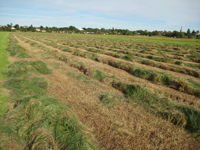
English: Hay making in Twyning Meadow. Upham Meadow at Twyning, known locally as Twyning Meadow, or sometimes Twyning Great Hay Meadow is one of the largest pieces of land for many miles around and is particularly noticeable when travelling south on the M5 motorway just after Junction 8.
What makes the meadow unusual is that its method of farming echoes back to feudal medieval England, for the 220 acre flood meadow is divided into 180 narrow strips which are owned by a number of farmers; however, the owners are able to take only the first math (mow the grass for hay) each year. They cannot fence their land off or restrict others from grazing. This is because from the 12th August each year until the 31st December, or the first flood of the winter, which ever occurs first, the land becomes common and anyone with grazing rights is entitled to graze their livestock in the meadow. The meadow is situated within a long curve in the River Avon and at its widest the meadow is half a mile wide. This land is known as the Long Meadow Ground and each of the strips of land are called Half Acres, confusingly they are actually one and a half acres in area. As well as the cutting of the first math ownership of these strips of land bring grazing rights on the commons in the parish of Twyning, amounting to approximately 600 acres. Ownership of each Half Acre strip provides the owner with grazing rights; these allow the grazing of thirty sheep, five cattle, or one and a half horses (mare and foal). These numbers are doubled when the meadow is available from 12th August; this is known as Double Stocking, though sheep are not allowed into the meadow until October. Grazing rights are also attached to certain cottages in the village, there are sixteen cottages claiming Cottage Rights, these rights still exist even though some of the cottages no longer do. Over the years ownership of the meadow has reflected farming trends and ownership of the land in the meadow has been consolidated, also owners will often swap or rent adjoining strips thereby producing larger patches making them more practical for large modern machinery, some of the smallest strips known as Varnells are as small as two yards wide. These days given favourable summer weather with large modern farm machinery the grass can be cut, the hay made and the bales collected within a week to ten days, but imagine the days before mechanisation when the meadow was cut by scythe. The meadow is an important site for wildlife and is now protected as a Site of Special Scientific Interest (SSSI) which imposes certain restrictions, for example the meadow cannot be cut before 15th June to protect nesting birds, which could happen if the grass was cut for silage. |
||
| Date | |||
| Source | From geograph.org.uk | ||
| Author | Philip Halling | ||
| Permission (Reusing this file) |
This file is licensed under the Creative Commons Attribution-Share Alike 2.0 Generic license. Attribution: Philip Halling
|
||
| Attribution (required by the license) | Philip Halling / Hay making in Twyning Meadow / | ||

| Camera location | | View this and other nearby images on: OpenStreetMap |
|---|
_heading:135.00&language=en)
| Object location | | View this and other nearby images on: OpenStreetMap |
|---|
_heading:135.00&language=en)

|
The categories of this image need checking. You can do so here.
|
File history
Click on a date/time to view the file as it appeared at that time.
| Date/Time | Thumbnail | Dimensions | User | Comment | |
|---|---|---|---|---|---|
| current | 16:11, 21 February 2011 | | 640 × 480 (113 KB) | GeographBot | == {{int:filedesc}} == {{Information |description={{en|1=Hay making in Twyning Meadow Upham Meadow at Twyning, known locally as Twyning Meadow, or sometimes Twyning Great Hay Meadow is one of the largest pieces of land for many miles around and is particu |