
File:Hurricane Isabel NC landfall radar.jpg

Size of this preview: 685 × 599 pixels. Other resolutions: 274 × 240 pixels | 549 × 480 pixels.
Original file (800 × 700 pixels, file size: 139 KB, MIME type: image/jpeg)
| This is a file from the Wikimedia Commons. Information from its description page there is shown below. Commons is a freely licensed media file repository. You can help. |
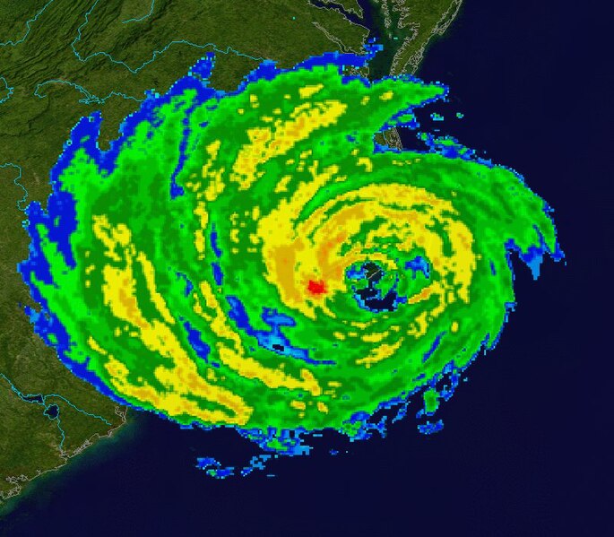
| Description | This image shows Hurricane Isabel at 16:59 p.m. EDT on September 18, 2003, as it was making its landfall in North Carolina as a Category 2 Hurricane. The radar data is from the NWS NEXRAD radar at Morehead City. The background is true colour imagery derived from NASA's MODIS satellites. | ||
| Date | |||
| Source | Radar data from the NCDC NEXRAD database. Background image is NASA Blue Marble imagery. | ||
| Author | Composite created by Nilfanion. | ||
| Permission (Reusing this file) |
|
File history
Click on a date/time to view the file as it appeared at that time.
| Date/Time | Thumbnail | Dimensions | User | Comment | |
|---|---|---|---|---|---|
| current | 17:07, 4 January 2007 | | 800 × 700 (139 KB) | Nilfanion | {{Information |Description=This image shows en:Hurricane Isabel at 16:59 p.m. EDT on September 18, 2003, as it was making its landfall in North Carolina as a Category 2 Hurricane. The radar data is from the NWS NEXRAD radar at [[:en:Morehead City, N |
File usage
The following pages on the English Wikipedia use this file (pages on other projects are not listed):
Global file usage
The following other wikis use this file:
- Usage on es.wikipedia.org
- Usage on zh.wikipedia.org