
File:ISS-36 Salton Trough.jpg

Size of this preview: 800 × 532 pixels. Other resolutions: 320 × 213 pixels | 640 × 426 pixels | 1,024 × 681 pixels | 1,280 × 852 pixels | 2,560 × 1,703 pixels | 4,256 × 2,832 pixels.
Original file (4,256 × 2,832 pixels, file size: 2.82 MB, MIME type: image/jpeg)
| This is a file from the Wikimedia Commons. Information from its description page there is shown below. Commons is a freely licensed media file repository. You can help. |
Summary
| Description |
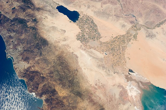
English: The Salton Trough is featured in this image photographed by an Expedition 36 crew member on the International Space Station.
|
| Date | |
| Source | http://spaceflight.nasa.gov/gallery/images/station/crew-36/html/iss036e011034.html |
| Author | NASA |
This image or video was catalogued by Johnson Space Center of the United States National Aeronautics and Space Administration (NASA) under Photo ID: ISS036-E-011034. This tag does not indicate the copyright status of the attached work. A normal copyright tag is still required. See Commons:Licensing. Other languages:
|
Licensing
This file is in the public domain in the United States because it was created by the Image Science & Analysis Laboratory, of the NASA Johnson Space Center. NASA copyright policy states that "NASA material is not protected by copyright unless noted". (NASA media use guidelines or Conditions of Use of Astronaut Photographs).
Photo source: ISS036-E-11034.
|
File history
Click on a date/time to view the file as it appeared at that time.
| Date/Time | Thumbnail | Dimensions | User | Comment | |
|---|---|---|---|---|---|
| current | 23:41, 17 August 2013 | | 4,256 × 2,832 (2.82 MB) | Ras67 | 180 degree rotated high quality rendering from NASA's raw data |
| 01:30, 30 July 2013 |  | 4,256 × 2,832 (1.55 MB) | Ras67 | == {{int:filedesc}} == {{Information |Description={{en|1=The Salton Trough is featured in this image photographed by an Expedition 36 crew member on the International Space Station. * The Imperial and Coachella Valleys of southern California – and th... |
File usage
The following pages on the English Wikipedia use this file (pages on other projects are not listed):
Global file usage
The following other wikis use this file:
- Usage on cs.wikipedia.org
- Usage on he.wikipedia.org