
File:LaRocheAuxFees Dolmen 2 20070408.jpg

Size of this preview: 800 × 372 pixels. Other resolutions: 320 × 149 pixels | 640 × 298 pixels | 1,024 × 477 pixels | 1,944 × 905 pixels.
Original file (1,944 × 905 pixels, file size: 436 KB, MIME type: image/jpeg)
| This is a file from the Wikimedia Commons. Information from its description page there is shown below. Commons is a freely licensed media file repository. You can help. |
Summary
| Description |
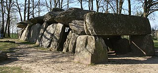
English: La Roche-aux-Fées, village of Essé, Ille-et-Vilaine, Brittany, France. It's a dolmen (gallery grave), the biggest in France, built near 2500 ~ 2000 B.C. Français : La Roche-aux-Fées, commune d'Essé, Ille-et-Vilaine, Bretagne, France. C'est un dolmen de type "allée couverte", le plus grand de France, datant de -2500 à -2000. |
| Date | |
| Source | Own work |
| Author | Sémhur |
| Attribution (required by the license) | © Sémhur / Wikimedia Commons / |
| Camera location | | View this and other nearby images on: OpenStreetMap |
|---|
Licensing
I, the copyright holder of this work, hereby publish it under the following licenses:
| Copyleft: This work of art is free; you can redistribute it and/or modify it according to terms of the Free Art License. You will find a specimen of this license on the Copyleft Attitude site as well as on other sites. |
This file is licensed under the Creative Commons Attribution-Share Alike 4.0 International, 3.0 Unported, 2.5 Generic, 2.0 Generic and 1.0 Generic license.
- You are free:
- to share – to copy, distribute and transmit the work
- to remix – to adapt the work
- Under the following conditions:
- attribution – You must give appropriate credit, provide a link to the license, and indicate if changes were made. You may do so in any reasonable manner, but not in any way that suggests the licensor endorses you or your use.
- share alike – If you remix, transform, or build upon the material, you must distribute your contributions under the same or compatible license as the original.
You may select the license of your choice.
File history
Click on a date/time to view the file as it appeared at that time.
| Date/Time | Thumbnail | Dimensions | User | Comment | |
|---|---|---|---|---|---|
| current | 11:40, 24 April 2007 | | 1,944 × 905 (436 KB) | Sémhur | {{location dms|47|56|11.764528225290292|N|1|24|18.096885681152344|W}} {{Information |Description= {{fr|La Roche-aux-Fées, commune d'Essé, Ille-et-Vilaine, Bretagne, France. C'est un dolmen de type "allée couverte", le pl |
File usage
The following pages on the English Wikipedia use this file (pages on other projects are not listed):
Global file usage
The following other wikis use this file:
- Usage on br.wikipedia.org
- Usage on ca.wikipedia.org
- Usage on ceb.wikipedia.org
- Usage on de.wikipedia.org
- Usage on es.wikipedia.org
- Usage on eu.wikipedia.org
- Usage on fr.wikipedia.org
- Usage on it.wikipedia.org
- Usage on ja.wikipedia.org
- Usage on ms.wikipedia.org
- Usage on nl.wikipedia.org
- Usage on oc.wikipedia.org
- Usage on pl.wikipedia.org
- Usage on ru.wikipedia.org
- Usage on sc.wikipedia.org
- Usage on sl.wikipedia.org
- Usage on sq.wikipedia.org
- Usage on vec.wikipedia.org
- Usage on www.wikidata.org