
File:Map Bandarban.jpg

Size of this preview: 307 × 599 pixels. Other resolutions: 123 × 240 pixels | 400 × 780 pixels.
Original file (400 × 780 pixels, file size: 47 KB, MIME type: image/jpeg)
| This is a file from the Wikimedia Commons. Information from its description page there is shown below. Commons is a freely licensed media file repository. You can help. |
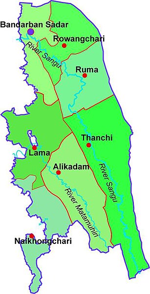
| Description | Map of Bandarban district |
| Date | |
| Source | Bangladesh Parjatan map |
| Author | user:Aditya Kabir |
| Permission (Reusing this file) |
Creative Commons Attribution-ShareAlike 3.0 License |

|
Permission is granted to copy, distribute and/or modify this document under the terms of the GNU Free Documentation License, Version 1.2 or any later version published by the Free Software Foundation; with no Invariant Sections, no Front-Cover Texts, and no Back-Cover Texts. A copy of the license is included in the section entitled GNU Free Documentation License. |
Licence: Creative Commons Attribution-ShareAlike 3.0 License.
File history
Click on a date/time to view the file as it appeared at that time.
| Date/Time | Thumbnail | Dimensions | User | Comment | |
|---|---|---|---|---|---|
| current | 11:47, 1 December 2009 | | 400 × 780 (47 KB) | Jolle~commonswiki | {{Information |Description=Map of Bandarban district |Source=Bangladesh Parjatan map |Date=2006 |Author=user:Aditya Kabir |Permission= Creative Commons Attribution-ShareAlike 3.0 License |other_versions= }} {{GFDL}} Licence: Creative Commons Attribu |
File usage
The following pages on the English Wikipedia use this file (pages on other projects are not listed):
Global file usage
The following other wikis use this file:
- Usage on ca.wikipedia.org
- Usage on de.wikipedia.org
- Usage on en.wikivoyage.org
- Usage on eo.wikipedia.org
- Usage on ml.wikipedia.org
- Usage on pt.wikipedia.org
- Usage on ru.wikipedia.org
- Usage on sat.wikipedia.org
- Usage on ta.wikipedia.org
- Usage on vi.wikipedia.org