
File:Map of Ciudad Jardin3.jpg
Size of this preview: 679 × 600 pixels. Other resolutions: 272 × 240 pixels | 543 × 480 pixels | 755 × 667 pixels.
Original file (755 × 667 pixels, file size: 237 KB, MIME type: image/jpeg)
| This is a file from the Wikimedia Commons. Information from its description page there is shown below. Commons is a freely licensed media file repository. You can help. |
Summary
| Description |
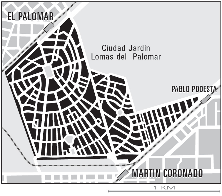
English: 1960s map layout of planned urban community Ciudad Jardín featuring three railway stations and three squares all between walking distance.
Español: Disposición de mapa de 1960 de la comunidad urbana planificada Ciudad Jardín con tres estaciones de ferrocarril y tres plazas, todas a poca distancia peatonal. |
| Date | 18 January 2007 (original upload date) |
| Source | Transferred from en.wikipedia. Original text: Personal Illustration |
| Author | Ciudad jardin at en.wikipedia |
Licensing
| This work has been released into the public domain by its author, Ciudad jardin at English Wikipedia. This applies worldwide. In some countries this may not be legally possible; if so: Ciudad jardin grants anyone the right to use this work for any purpose, without any conditions, unless such conditions are required by law. |
Original upload log
The original description page was Ciudad Jardin Lomas de Palomar.jpg here. All following user names refer to en.wikipedia.
- 2007-01-18 18:18 Ciudad jardin 755×667× (242874 bytes) Peronal Illustration
File history
Click on a date/time to view the file as it appeared at that time.
| Date/Time | Thumbnail | Dimensions | User | Comment | |
|---|---|---|---|---|---|
| current | 19:01, 20 April 2009 | | 755 × 667 (237 KB) | Moebiusuibeom-en | {{Information |Description={{en|1=Map of urban area}} |Source=Own work by uploader |Author=Moebiusuibeom-en |Date=09/04/09 |Permission= |other_versions= }} <!--{{ImageUpload|full}}--> |
File usage
No pages on the English Wikipedia use this file (pages on other projects are not listed).
Global file usage
The following other wikis use this file:
- Usage on es.wikipedia.org