
File:Media.PNG
No higher resolution available.
Media.PNG (474 × 469 pixels, file size: 42 KB, MIME type: image/png)
| This is a file from the Wikimedia Commons. Information from its description page there is shown below. Commons is a freely licensed media file repository. You can help. |
Summary
| Description |
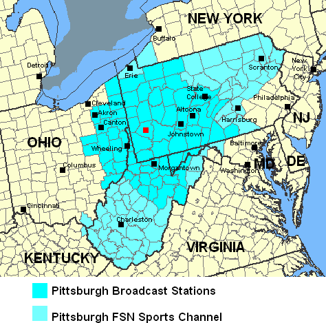
English: Data is from the National Atlas Website from the Federal Govt. It has been modified by Marketdiamond with geographic names and county coloration to depict the reach of Pittsburgh media. |
| Source | Data is from the National Atlas Website from the Federal Govt. It has been modified by Marketdiamond with geographic names and county coloration to depict the reach of Pittsburgh media. |
| Author | See source |
Licensing
This map was obtained from an edition of the National Atlas of the United States. Like almost all works of the U.S. federal government, works from the National Atlas are in the public domain in the United States.
Online access: NationalAtlas.gov | 1970 print edition: Library of Congress, Perry-Castañeda Library
|
Original upload log
The original description page was here. All following user names refer to en.wikipedia.
- 2008-09-08 23:55 Marketdiamond 474×469× (43144 bytes) Data is from the National Atlas Website from the Federal Govt. It has been modified by Hholt01 with geographic names and county coloration to depict the reach of Pittsburgh media.
- 2007-10-11 08:45 Marketdiamond 474×469× (43038 bytes) (right sized this image) Data is from the National Atlas Website from the Federal Govt. It has been modified by Hholt01 with geographic names and county coloration to depict the reach of Pittsburgh media.
- 2007-10-08 22:54 Marketdiamond 975×650× (55040 bytes) Data is from the National Atlas Website from the Federal Govt. It has been modified by Hholt01 with geographic names and county coloration to depict the reach of Pittsburgh media.
- 2007-08-18 07:04 Marketdiamond 975×650× (54750 bytes) Data is from the National Atlas Website from the Federal Govt. It has been modified by Hholt01 with geographic names and county coloration to depict the reach of Pittsburgh media.
File history
Click on a date/time to view the file as it appeared at that time.
| Date/Time | Thumbnail | Dimensions | User | Comment | |
|---|---|---|---|---|---|
| current | 09:47, 19 April 2013 | | 474 × 469 (42 KB) | OgreBot | (BOT): Reverting to most recent version before archival |
| 09:47, 19 April 2013 |  | 474 × 469 (42 KB) | OgreBot | (BOT): Uploading old version of file from en.wikipedia; originally uploaded on 2007-10-11 08:45:24 by Marketdiamond | |
| 09:47, 19 April 2013 |  | 975 × 650 (54 KB) | OgreBot | (BOT): Uploading old version of file from en.wikipedia; originally uploaded on 2007-10-08 22:54:20 by Marketdiamond | |
| 09:46, 19 April 2013 |  | 975 × 650 (53 KB) | OgreBot | (BOT): Uploading old version of file from en.wikipedia; originally uploaded on 2007-08-18 07:04:57 by Marketdiamond | |
| 20:50, 12 January 2012 |  | 474 × 469 (42 KB) | MGA73bot2 | {{BotMoveToCommons|en.wikipedia|year={{subst:CURRENTYEAR}}|month={{subst:CURRENTMONTHNAME}}|day={{subst:CURRENTDAY}}}} {{Information |Description={{en|Data is from the National Atlas Website from the Federal Govt. It has been modified by Hholt01 with ge |
File usage
The following pages on the English Wikipedia use this file (pages on other projects are not listed):
Global file usage
The following other wikis use this file:
- Usage on fr.wikipedia.org