
File:Mugello Racing Circuit track map.svg

Size of this PNG preview of this SVG file: 800 × 501 pixels. Other resolutions: 320 × 200 pixels | 640 × 401 pixels | 1,024 × 641 pixels | 1,280 × 801 pixels | 2,560 × 1,603 pixels | 1,391 × 871 pixels.
Original file (SVG file, nominally 1,391 × 871 pixels, file size: 64 KB)
| This is a file from the Wikimedia Commons. Information from its description page there is shown below. Commons is a freely licensed media file repository. You can help. |
Summary
| Description |
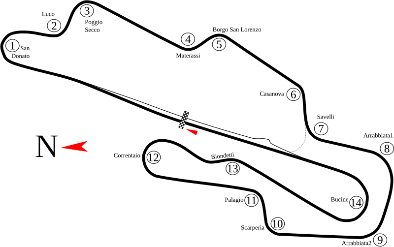
English: Track map of Mugello Circuit in Italy. The gray dashed line represents pavement that has the same width as the main track, but only leads to pit road. Because of its location, the author of this image believes that it is only used by cars needing a shorter route back to the paddock. |
| Date | 8-5-2008 |
| Source | Own work |
| Author | Will Pittenger |
| Other versions |
|
.png)
This W3C-unspecified vector image was created with Inkscape .
| Camera location | | View this and other nearby images on: OpenStreetMap |
|---|
Licensing
I, the copyright holder of this work, hereby publish it under the following license:
This file is licensed under the Creative Commons Attribution-Share Alike 3.0 Unported license.
- You are free:
- to share – to copy, distribute and transmit the work
- to remix – to adapt the work
- Under the following conditions:
- attribution – You must give appropriate credit, provide a link to the license, and indicate if changes were made. You may do so in any reasonable manner, but not in any way that suggests the licensor endorses you or your use.
- share alike – If you remix, transform, or build upon the material, you must distribute your contributions under the same or compatible license as the original.
File history
Click on a date/time to view the file as it appeared at that time.
| Date/Time | Thumbnail | Dimensions | User | Comment | |
|---|---|---|---|---|---|
| current | 22:23, 4 July 2010 | | 1,391 × 871 (64 KB) | Restu20 | correct some name |
| 09:16, 5 August 2008 |  | 1,391 × 871 (64 KB) | Will Pittenger | New version fixes the vertical black bar that shouldn't have been there. (It was actually an unneeded flowed text box that got in somehow.) | |
| 08:54, 5 August 2008 |  | 1,391 × 871 (64 KB) | Will Pittenger | New version has the turn numbers grouped to matching turn names | |
| 08:45, 5 August 2008 |  | 1,391 × 871 (63 KB) | Will Pittenger | New version has larger North Arrow and Start/Finish line | |
| 08:32, 5 August 2008 |  | 1,391 × 871 (62 KB) | Will Pittenger | {{Information |Description={{en|1=Track map of w:Mugello Circuit in Italy. The gray dashed line represents pavement that has the same width as the main track, but only leads to pit road. Because of its location, the author of this image believes th |
File usage
No pages on the English Wikipedia use this file (pages on other projects are not listed).
Global file usage
The following other wikis use this file:
- Usage on ar.wikipedia.org
- جائزة إيطاليا الكبرى للدراجات النارية 2006
- حلبة موجيلو
- جائزة إيطاليا الكبرى للدراجات النارية 2004
- جائزة إيطاليا الكبرى للدراجات النارية 2005
- جائزة إيطاليا الكبرى للدراجات النارية 2007
- جائزة إيطاليا الكبرى للدراجات النارية 2008
- جائزة إيطاليا الكبرى للدراجات النارية 2009
- جائزة إيطاليا الكبرى للدراجات النارية 2010
- جائزة إيطاليا الكبرى للدراجات النارية 2011
- جائزة إيطاليا الكبرى للدراجات النارية 2012
- جائزة إيطاليا الكبرى للدراجات النارية 2013
- جائزة إيطاليا الكبرى للدراجات النارية 2014
- جائزة إيطاليا الكبرى للدراجات النارية 2015
- جائزة إيطاليا الكبرى للدراجات النارية 1992
- جائزة إيطاليا الكبرى للدراجات النارية 1994
- جائزة إيطاليا الكبرى للدراجات النارية 1995
- جائزة إيطاليا الكبرى للدراجات النارية 1996
- جائزة إيطاليا الكبرى للدراجات النارية 1997
- جائزة إيطاليا الكبرى للدراجات النارية 1998
- جائزة إيطاليا الكبرى للدراجات النارية 1999
- جائزة إيطاليا الكبرى للدراجات النارية 2000
- جائزة سان مارينو الكبرى للدراجات النارية 1991
- جائزة سان مارينو الكبرى للدراجات النارية 1993
- جائزة الأمم الكبرى للدراجات النارية 1978
- جائزة الأمم الكبرى للدراجات النارية 1976
- جائزة إيطاليا الكبرى للدراجات النارية 2018
- جائزة إيطاليا الكبرى للدراجات النارية 2019
- Usage on ast.wikipedia.org
- Usage on ca.wikipedia.org
- Usage on cs.wikipedia.org
- Usage on de.wikipedia.org
- Usage on es.wikipedia.org
- Anexo:Grandes Premios de Fórmula 1
- Anexo:Circuitos de Fórmula 1
- Autódromo Internacional del Mugello
- Gran Premio de Italia de Motociclismo
- Temporada 2012 de Fórmula 1
- Anexo:Pretemporada 2012 de Fórmula 1
- Temporada 2014 de MotoGP
- Gran Premio de Italia de Motociclismo de 2012
- Gran Premio de Italia de Motociclismo de 2013
- Gran Premio de Italia de Motociclismo de 2014
- Gran Premio de Italia de Motociclismo de 2015
- Gran Premio de Italia de Motociclismo de 2016
View more global usage of this file.