
File:Nauru map 1914 15000.png

Size of this preview: 572 × 600 pixels. Other resolutions: 229 × 240 pixels | 458 × 480 pixels | 733 × 768 pixels | 977 × 1,024 pixels | 1,954 × 2,048 pixels | 3,000 × 3,145 pixels.
Original file (3,000 × 3,145 pixels, file size: 7.07 MB, MIME type: image/png)
| This is a file from the Wikimedia Commons. Information from its description page there is shown below. Commons is a freely licensed media file repository. You can help. |
Summary
| Description |
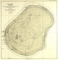
English: map of Nauru (Ānā́ọĕṙọ), central pacific, origin size 40 cm x 41 cm |
| Date | |
| Source | back foldable inset map of Paul Hambruch: Nauru (1. Halbband), Ergebnisse der Südsee-Expedition 1908-1910 |
| Author | Beamte der Pacific Phosphate Co.Ltd. und Ergänzungen von Paul Hambruch |
| Permission (Reusing this file) |
|

Licensing
|
This work is in the public domain in its country of origin and other countries and areas where the copyright term is the author's life plus 70 years or fewer. This work is in the public domain in the United States because it was published (or registered with the U.S. Copyright Office) before January 1, 1929. | |
| This file has been identified as being free of known restrictions under copyright law, including all related and neighboring rights. | |
File history
Click on a date/time to view the file as it appeared at that time.
| Date/Time | Thumbnail | Dimensions | User | Comment | |
|---|---|---|---|---|---|
| current | 20:35, 2 November 2014 | | 3,000 × 3,145 (7.07 MB) | BlueBreezeWiki | User created page with UploadWizard |
File usage
No pages on the English Wikipedia use this file (pages on other projects are not listed).
Global file usage
The following other wikis use this file:
- Usage on azb.wikipedia.org
- Usage on de.wikipedia.org
- Usage on es.wikipedia.org