
File:NewGuineaSelonUsher.png

Size of this preview: 800 × 265 pixels. Other resolutions: 320 × 106 pixels | 640 × 212 pixels | 1,024 × 339 pixels | 2,633 × 871 pixels.
Original file (2,633 × 871 pixels, file size: 339 KB, MIME type: image/png)
| This is a file from the Wikimedia Commons. Information from its description page there is shown below. Commons is a freely licensed media file repository. You can help. |

|
This linguistic map image could be re-created using vector graphics as an SVG file. This has several advantages; see Commons:Media for cleanup for more information. If an SVG form of this image is available, please upload it and afterwards replace this template with
{{vector version available|new image name}}.
It is recommended to name the SVG file “NewGuineaSelonUsher.svg”—then the template Vector version available (or Vva) does not need the new image name parameter. |
Summary
| Description |
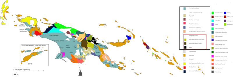
English: Linguistic map of New Guinea and surrounding islands, including the North Moluccas, Solomon Islands, the Torres Strait Islands and Northern Australia. Classification of the Languages East of New Guinea proper was not taken into consideration by Usher. The Yele Dinye language isolate of Rossel Island is either West New Britain or Austronesian, and is shown as striped with both colours. |
| Date | |
| Source | Own work |
| Author | MToumbola |
Licensing
I, the copyright holder of this work, hereby publish it under the following license:
This file is licensed under the Creative Commons Attribution-Share Alike 4.0 International license.
- You are free:
- to share – to copy, distribute and transmit the work
- to remix – to adapt the work
- Under the following conditions:
- attribution – You must give appropriate credit, provide a link to the license, and indicate if changes were made. You may do so in any reasonable manner, but not in any way that suggests the licensor endorses you or your use.
- share alike – If you remix, transform, or build upon the material, you must distribute your contributions under the same or compatible license as the original.
File history
Click on a date/time to view the file as it appeared at that time.
| Date/Time | Thumbnail | Dimensions | User | Comment | |
|---|---|---|---|---|---|
| current | 12:25, 2 March 2019 | 2,633 × 871 (339 KB) | MToumbola | Added Central Solomons Languages | |
| 11:18, 2 March 2019 | 2,633 × 871 (339 KB) | MToumbola | Expanded Map to include all known Papuan languages. | ||
| 08:13, 28 January 2019 | 1,850 × 762 (342 KB) | MToumbola | Removed Extra Line | ||
| 13:18, 27 January 2019 | 1,850 × 762 (342 KB) | MToumbola | Cleaned Up Borders | ||
| 14:32, 20 January 2019 | 1,850 × 762 (382 KB) | MToumbola | Clean=Up Final | ||
| 13:48, 20 January 2019 | 1,850 × 762 (384 KB) | MToumbola | Miscolour in previous (Final Version). | ||
| 13:45, 20 January 2019 | 1,850 × 762 (384 KB) | MToumbola | Clean Up | ||
| 13:35, 20 January 2019 | 1,850 × 762 (392 KB) | MToumbola | Corrections | ||
| 11:44, 20 January 2019 | 1,850 × 762 (384 KB) | MToumbola | Added Papuan Gulf. | ||
| 10:33, 20 January 2019 | 1,890 × 774 (368 KB) | MToumbola | Cleaned Up TNG branches. |
File usage
The following pages on the English Wikipedia use this file (pages on other projects are not listed):
Global file usage
The following other wikis use this file:
- Usage on de.wikivoyage.org
- Usage on fr.wikipedia.org
- Usage on ko.wikipedia.org
- Usage on ms.wikipedia.org
- Usage on nl.wikipedia.org
- Usage on nn.wikipedia.org
- Usage on oc.wikipedia.org
- Usage on ro.wikipedia.org