
File:PIA17361-MarsCuriosityRover-Darwin-Closeup-Waypoint1-20130921.jpg

Original file (4,812 × 1,008 pixels, file size: 1.81 MB, MIME type: image/jpeg)
| This is a file from the Wikimedia Commons. Information from its description page there is shown below. Commons is a freely licensed media file repository. You can help. |
Summary
| Description |
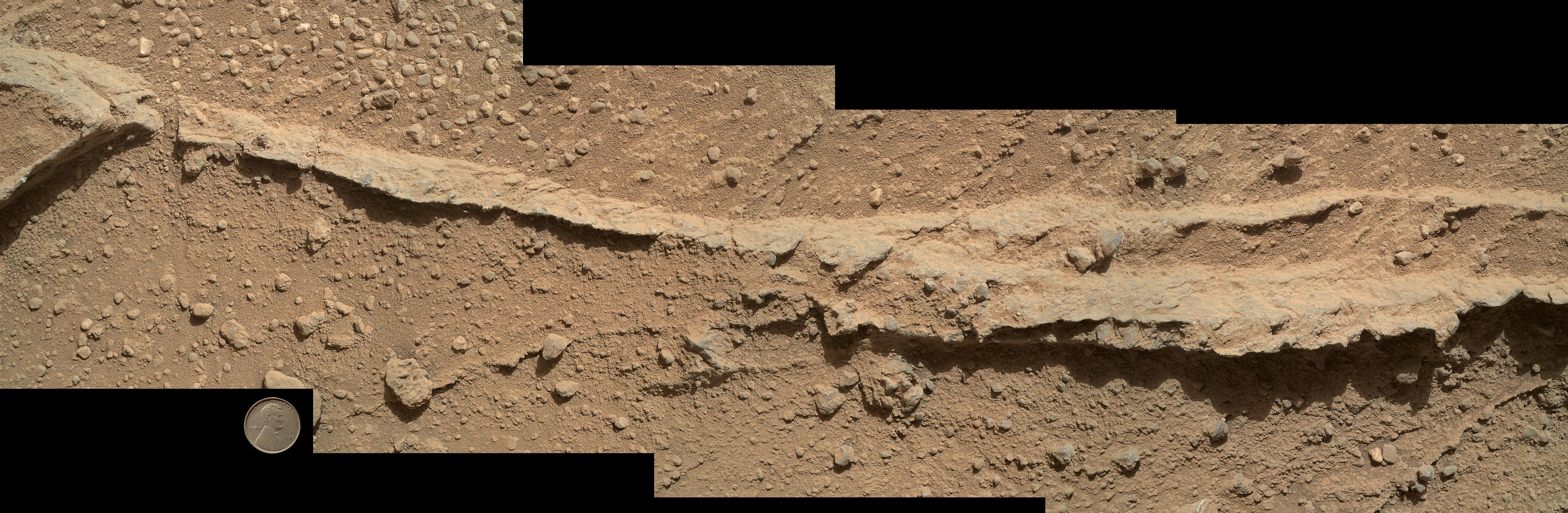
English: PIA17361: Close-up of Ridge in Rock Outcrop at Curiosity's 'Waypoint 1.'
http://photojournal.jpl.nasa.gov/catalog/PIA17361 This mosaic of four images taken by the Mars Hand Lens Imager (MAHLI) camera on NASA's Mars rover Curiosity shows detailed texture in a ridge that stands higher than surrounding rock. The rock is at a location called "Darwin," inside Gale Crater. Exposed outcrop at this location, visible in images from the High Resolution Imaging Science Experment (HiRISE) camera on NASA's Mars Reconnaissance Orbiter, prompted Curiosity's science team to select it as the mission's first waypoint for several days during the mission's long trek from the "Glenelg" area to Mount Sharp. MAHLI took the component images shortly before sunset on the 400th Martian day, or sol, of Curiosity's work on Mars (Sept. 21, 2013). The camera was positioned about 10 inches (25 centimeters) from the rock. Scale is indicated by the Lincoln penny from the MAHLI calibration target, shown beside the mosaic. The ridge resulted from a crack or vein in the surrounding rock becoming filled with material that was subsequently more resistant to erosion than the material of the surrounding rock. Researchers are investigating the textures and composition of ridges and the surrounding rock, which is a pebbly sandstone conglomerate. Reddish dust coats the surfaces seen in this image. The underlying rocks are gray, varying from nearly white to nearly black. The host rock in which the crack or vein formed is obscured in this image by the coating of dust and a thin layer of the rock's own debris -- loose pebbles and sand. Researchers also examined ridges at Waypoint 1 with Curiosity's Alpha Particle X-ray Spectrometer (APXS), Chemistry and Camera (ChemCam) instrument and Mast Camera (Mastcam). Malin Space Science Systems, San Diego, developed, built and operates MAHLI. NASA's Jet Propulsion Laboratory, Pasadena, Calif., manages the Mars Science Laboratory Project and the mission's Curiosity rover for NASA's Science Mission Directorate in Washington. The rover was designed and assembled at JPL, a division of the California Institute of Technology in Pasadena. More information about Curiosity is online at http://www.nasa.gov/msl and http://mars.jpl.nasa.gov/msl/. Image Addition Date: 2013-09-23Polski: Zbliżenie grzbietu odkrywki skalnej, na przystanku 1 łazika Curiosity, na trasie "Szybki marsz" Ta składająca się z czterech zdjęć mozaika wykonana przez kamerę MAHLI znajdującą się na należącym do NASA łaziku Curiosity pokazuje szczegółowe tekstury grzbietu, wychodni skalnej, która wystaje ponad otaczające ją podłoże. Skała znajduje się w miejscu o nazwie "Darwin" wewnątrz krateru Gale. Ta naturalnie wyeksponowana odkrywka jest widoczna na wysokiej rozdzielczości zdjęciach teleskopu zwierciedlanego (HiRISE) znajdującego się na pokładzie należącej do NASA sondy Mars Reconnaissance Orbiter, została wytypowana przez zespół naukowy Curiosity, jako miejsce pierwszego kilkudniowego przystanku (Waypoint 1), w czasie długiej wędrówki z obszaru Glenelg do Mount Sharp. Kamera MAHLI wykonała ten zestaw zdjęć krótko przed zachodem słońca w 400 dniu marsjańskiej misji łazika Curiosity (Sol 400), na Ziemi był wtedy 21 września 2013. Kamera została umieszczona około 25 cm) od skały. W celu kalibracji zobrazowania obrazu kamery MAHLI poza obrazem mozaiki umieszczona jest skala w postaci pensa Lincolna. Wystający grzbiet jest efektem pęknięcia, lub jest żyłą skały wypełnionej materiałem, który jest bardziej odporny na erozję, niż materiał w otaczającej skale. Naukowcy badają teksturę i kompozycję składu grzbietu i otaczającej skały, która jest konglomeratem kamieni i piaskowca. Na zdjęciach widoczny jest czerwonawy płaszcz kurzu pokrywający powierzchnię podłoża. Leżące pod nim skały są szare, ich barwa zmienia się od prawie białej do prawie czarnej. Podstawa skalna, w której powstało pęknięcie, lub utworzyła się żyła, jest na tym zdjęciu przykryta przez powłokę kurzu i cienką warstwę własnego gruzu - luźne kamyki i piasek. Naukowcy zbadali także grzbiet skały na przystanku 1 (Waypoint 1) następującymi instrumentami łazika Curiosity: APXS, ChemCam i Kamery masztowe. Przedsiębiorstwo Malin Space Science Systems znajdujące się w San Diego, opracowało, zbudowało i obsługuje MAHLI. Należący do NASA centrum badawcze Jet Propulsion Laboratory (JPL) w Pasadenie, znajdujące się w stanie Kalifornia kieruje projektem Mars Science Laboratory i misją Curiosity dla należącego do NASA dyrektoriatu Science Mission Directorate w Waszyngtonie. Łazik został zaprojektowany i zmontowany w JPL, będącym oddziałem Kalifornijskiego Instytutu Technologii w Pasadenie. |
| Date | |
| Source | http://photojournal.jpl.nasa.gov/jpeg/PIA17361.jpg |
| Author | NASA/JPL-Caltech/MSSS |
Licensing
| This file is in the public domain in the United States because it was solely created by NASA. NASA copyright policy states that "NASA material is not protected by copyright unless noted". (See Template:PD-USGov, NASA copyright policy page or JPL Image Use Policy.) | ||
 |
Warnings:
|
File history
Click on a date/time to view the file as it appeared at that time.
| Date/Time | Thumbnail | Dimensions | User | Comment | |
|---|---|---|---|---|---|
| current | 15:39, 3 May 2014 | 4,812 × 1,008 (1.81 MB) | Drbogdan | cropped original image (via JASC Paint Shop Pro v6.02) - maybe a better view. | |
| 17:27, 24 September 2013 | 4,818 × 1,577 (1.8 MB) | Drbogdan | User created page with UploadWizard |
File usage
Global file usage
The following other wikis use this file:
- Usage on de.wikipedia.org
- Usage on pl.wikipedia.org
- Usage on zh.wikipedia.org