
File:Pentarchy year 1000.jpg
Size of this preview: 800 × 439 pixels. Other resolutions: 320 × 176 pixels | 640 × 352 pixels | 1,024 × 562 pixels | 1,471 × 808 pixels.
Original file (1,471 × 808 pixels, file size: 624 KB, MIME type: image/jpeg)
| This is a file from the Wikimedia Commons. Information from its description page there is shown below. Commons is a freely licensed media file repository. You can help. |
Summary
| Description |
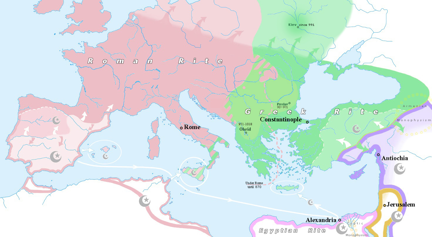
English: Map of the Pentarchy, year 1000. Synthesis between the two maps cited. White interior: conquered by the Islamic Caliphates. White lined: temporarily occupied by the Islamic Caliphates or Emirates. Arrows: expansion since year 800. |
| Date | |
| Source |
Own work map, derivative since two others: background File:Blank map of South Europe and North Africa.svg and Michaël Buecker's File:1800 Wilkinson Map of the 4 Eastern Churches rectified.jpg |
| Author | Trecătorul răcit |
Licensing
I, the copyright holder of this work, hereby publish it under the following license:
This file is licensed under the Creative Commons Attribution-Share Alike 4.0 International license.
- You are free:
- to share – to copy, distribute and transmit the work
- to remix – to adapt the work
- Under the following conditions:
- attribution – You must give appropriate credit, provide a link to the license, and indicate if changes were made. You may do so in any reasonable manner, but not in any way that suggests the licensor endorses you or your use.
- share alike – If you remix, transform, or build upon the material, you must distribute your contributions under the same or compatible license as the original.
File history
Click on a date/time to view the file as it appeared at that time.
| Date/Time | Thumbnail | Dimensions | User | Comment | |
|---|---|---|---|---|---|
| current | 09:04, 20 April 2021 | | 1,471 × 808 (624 KB) | Trecătorul răcit | Detail added, thanks to Veverve. |
| 12:18, 16 April 2021 |  | 1,471 × 808 (614 KB) | Trecătorul răcit | Preslav added | |
| 13:14, 14 April 2021 |  | 1,471 × 808 (612 KB) | Trecătorul răcit | Rites, details since sources and https://commons.wikimedia.org/wiki/File:1800_Wilkinson_Map_of_the_4_Eastern_Churches_rectified.jpg | |
| 15:58, 19 April 2020 |  | 1,471 × 808 (582 KB) | Trecătorul răcit | Colors | |
| 02:22, 5 March 2020 |  | 1,471 × 808 (269 KB) | Ceha | Bosnia | |
| 13:53, 28 December 2018 |  | 1,471 × 808 (603 KB) | Trecătorul răcit | More details, cosmetic | |
| 12:23, 30 November 2018 |  | 1,471 × 808 (593 KB) | Trecătorul răcit | Cosmetic, rivers | |
| 15:15, 14 October 2018 |  | 1,471 × 808 (578 KB) | Trecătorul răcit | Cosmetic | |
| 13:07, 10 July 2018 |  | 1,471 × 808 (580 KB) | Trecătorul răcit | Details | |
| 21:58, 6 July 2018 |  | 1,471 × 808 (575 KB) | Trecătorul răcit | Expansion areas |
File usage
The following pages on the English Wikipedia use this file (pages on other projects are not listed):
Global file usage
The following other wikis use this file:
- Usage on ca.wikipedia.org
- Usage on el.wikipedia.org
- Usage on es.wikipedia.org
- Usage on fr.wikipedia.org
- Usage on ml.wikipedia.org
- Usage on pt.wikipedia.org
- Usage on sk.wikipedia.org
- Usage on tr.wikipedia.org