
File:Population change from 2011 to 2021 UK.svg

Size of this PNG preview of this SVG file: 324 × 600 pixels. Other resolutions: 129 × 240 pixels | 259 × 480 pixels | 415 × 768 pixels | 553 × 1,024 pixels | 1,106 × 2,048 pixels | 512 × 948 pixels.
Original file (SVG file, nominally 512 × 948 pixels, file size: 835 KB)
| This is a file from the Wikimedia Commons. Information from its description page there is shown below. Commons is a freely licensed media file repository. You can help. |
Summary
| Description |
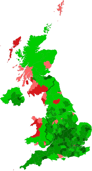
English: Population change from 2011 to 2021 UK, data is unavailable for Scotland and Northern Ireland
This file should be and can be freely edited and updated once information for Scotland and Northern Ireland are released (NI: 20th of September, Scotland: Unknown date in 2023) More than -3%
-0 - 3%
+0 - 5%
+5 - 10%
More than +10% |
| Date | |
| Source | Own work, data taken from the Population and household estimates, England and Wales: Census 2021 page on the ONS website for England and Wales. Figures for Northern Ireland taken from Northern Ireland Census Data from the NIRSA website by interactievly clicking on each Local Government District. |
| Author | Tweedle |
Licensing
I, the copyright holder of this work, hereby publish it under the following license:
This file is licensed under the Creative Commons Attribution-Share Alike 4.0 International license.
- You are free:
- to share – to copy, distribute and transmit the work
- to remix – to adapt the work
- Under the following conditions:
- attribution – You must give appropriate credit, provide a link to the license, and indicate if changes were made. You may do so in any reasonable manner, but not in any way that suggests the licensor endorses you or your use.
- share alike – If you remix, transform, or build upon the material, you must distribute your contributions under the same or compatible license as the original.
File history
Click on a date/time to view the file as it appeared at that time.
| Date/Time | Thumbnail | Dimensions | User | Comment | |
|---|---|---|---|---|---|
| current | 17:46, 12 February 2024 | | 512 × 948 (835 KB) | AlloDoon | Added Scotland |
| 23:01, 13 April 2023 |  | 512 × 948 (818 KB) | Tweedle | fixed the demarkations for North Northamptonshire, West Northamptonshire, Buckinghamshire, could not find a way to show it as one thing but figured out now how to | |
| 16:06, 27 September 2022 |  | 512 × 948 (817 KB) | Tweedle | added Northern Irish figures | |
| 23:29, 19 September 2022 |  | 512 × 948 (771 KB) | Tweedle | Reverted to version as of 23:23, 19 September 2022 (UTC) | |
| 23:28, 19 September 2022 |  | 512 × 948 (817 KB) | Tweedle | file re-correct attempt number 2, hopefully this fix's properly? | |
| 23:23, 19 September 2022 |  | 512 × 948 (771 KB) | Tweedle | incorrect colour denoted on newport | |
| 16:35, 29 August 2022 |  | 512 × 948 (766 KB) | Tweedle | Uploaded own work with UploadWizard |
File usage
The following pages on the English Wikipedia use this file (pages on other projects are not listed):