
File:R-M458 frequency distribution.PNG
No higher resolution available.
R-M458_frequency_distribution.PNG (545 × 352 pixels, file size: 21 KB, MIME type: image/png)
| This is a file from the Wikimedia Commons. Information from its description page there is shown below. Commons is a freely licensed media file repository. You can help. |
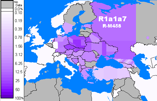
| Description | Map rendered in psuedocolors for R-M458 frequencies, data derived from Underhill et al. Positions of boundaries (NE,NW,C,etc) are approximate. Variation of N and S. Caucasus region of Russia rendered as stripes showing range of variation in the region. |
| Date | (UTC) |
| Source | |
| Author |
|
| This is a retouched picture, which means that it has been digitally altered from its original version. The original can be viewed here: BlankMap-World-large.png:
|
I, the copyright holder of this work, hereby publish it under the following license:
| I, the copyright holder of this work, release this work into the public domain. This applies worldwide. In some countries this may not be legally possible; if so: I grant anyone the right to use this work for any purpose, without any conditions, unless such conditions are required by law. |
Original upload log
This image is a derivative work of the following images:
- File:BlankMap-World-large.png licensed with PD-self
- 2009-08-16T06:21:16Z Hoshie 2753x1400 (177773 Bytes) added Kosovo; see [[see Image talk:Continental-Europe-map.png#Kosovo - a solution]] for details
- 2009-07-18T07:08:36Z Hoshie 2753x1400 (180358 Bytes) Added Liechtenstein based on [[:File:Recognition problems Barry Kent.png]]
- 2009-01-16T05:27:26Z Roke 2753x1400 (104750 Bytes) antarctica
- 2006-11-27T02:40:48Z Roke 2753x1400 (155712 Bytes) Derived from svg map [[en:Image:BlankMap-World3.svg]] {{PD-self}} [[Category:Blank world maps]]
Uploaded with derivativeFX
File history
Click on a date/time to view the file as it appeared at that time.
| Date/Time | Thumbnail | Dimensions | User | Comment | |
|---|---|---|---|---|---|
| current | 06:10, 25 November 2009 | | 545 × 352 (21 KB) | Pdeitiker | {{Information |Description=Map rendered in psuedocolors for R-M458 frequencies, data derived from Underhill et al. Positions of boundaries (NE,NW,C,etc) are approximate. Variation of N and S. Caucasus region of Russia rendered as stripes showing range of |
File usage
The following pages on the English Wikipedia use this file (pages on other projects are not listed):
Global file usage
The following other wikis use this file:
- Usage on fr.wikipedia.org
- Usage on mk.wikipedia.org
- Usage on ru.wikipedia.org