
File:São Miguel, Azores ESA399763.jpg

Original file (6,596 × 3,267 pixels, file size: 2.55 MB, MIME type: image/jpeg)
| This is a file from the Wikimedia Commons. Information from its description page there is shown below. Commons is a freely licensed media file repository. You can help. |
Summary
| Description |
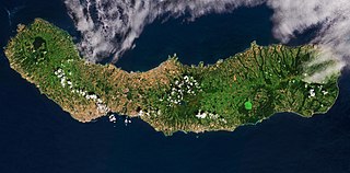
English: The Copernicus Sentinel-2A satellite takes us over the largest island of the Azores: São Miguel. Resting at the intersection of the Eurasian, African and North American tectonic plates, the Azores form a string of volcanic islands in the North Atlantic Ocean, some 1500 km west of mainland Portugal. The nine major islands are divided into three groups, with São Miguel falling into the eastern group.
The archipelago is an autonomous region of Portugal and home to just under 250 000 people. We can see the capital of the region, Ponta Delgada, in the bottom left of the image. The main transport hub of the Azores, João Paulo II de Ponta Delgada International Airport, is clearly visible in the same part of the image. Tourism is an important industry for the islands, with visitors flocking to enjoy the unspoilt beaches and breathtaking landscapes, from the geysers of São Miguel to the natural waterfalls of Flores. Known locally as the Green Island, São Miguel is the most populous of the islands and amidst the lush foliage, volcanic craters, and freshwater lakes, visitors are spoilt for choice when it comes to visual attractions. The largest freshwater lake in the Azores, Lagoa das Sete Cidades, can be seen in the top left of the image. It lies in a large volcanic crater and consists of two lakes: Lagoa Azul and Lagoa Verde. On the right of the image we can see Furnas Lake, in the Furnas Valley, famous for its volcanic cones. The volcanic landscape of the island has even influenced local cooking methods. Cozido das Furnas, a stew-type dish, is prepared by lowering a pot filled with meat and vegetables into the hot springs dotted around the valley, and leaving it to cook for around five hours. The Azores islands are rich in terms of flora and fauna, and are home to a large number of resident and migratory bird populations. Efforts are being made to restore and expand the laurel forests typical of the Macaronesian islands (an area covering the archipelagos of Madeira, Azores, Canary Islands and Cape Verde) as only around 2% of the native laurel forest remains on the islands. ESA, in collaboration with the French Space Agency, CNES, is organising a symposium on25 years of progress in radar altimetry, which will be held in Ponta Delgada from 24–29 September. With global sea-level rise a global concern, the symposium will focus on the advances made in our understanding of the open ocean, the cryosphere, and coastal and land processes. The annual meeting of the Ocean Surface Topography Science Team and the International DORIS Service Workshop will also be held in the same week. This image, which was captured on 8 September 2016, is also featured on theEarth from Space video programme. |
| Date | |
| Source | http://www.esa.int/spaceinimages/Images/2018/09/Sao_Miguel_Azores |
| Author | European Space Agency |
| Permission (Reusing this file) |
contains modified Copernicus Sentinel data (2016), processed by ESA,CC BY-SA 3.0 IGO |
| Other versions |
|
| Title | São Miguel, Azores |
| System | Copernicus |
| Set | Earth observation image of the week |
| Location | Azores |
| Mission | Sentinel-2 |
| Activity | Observing the Earth |

Licensing
This media was created by the European Space Agency (ESA).
Where expressly so stated, images or videos are covered by the Creative Commons Attribution-ShareAlike 3.0 IGO (CC BY-SA 3.0 IGO) licence, ESA being an Intergovernmental Organisation (IGO), as defined by the CC BY-SA 3.0 IGO licence. The user is allowed under the terms and conditions of the CC BY-SA 3.0 IGO license to Reproduce, Distribute and Publicly Perform the ESA images and videos released under CC BY-SA 3.0 IGO licence and the Adaptations thereof, without further explicit permission being necessary, for as long as the user complies with the conditions and restrictions set forth in the CC BY-SA 3.0 IGO licence, these including that:
See the ESA Creative Commons copyright notice for complete information, and this article for additional details.
|
 | |
This file is licensed under the Creative Commons Attribution-ShareAlike 3.0 IGO license. Attribution: ESA, CC BY-SA IGO 3.0
| ||

|
This image contains data from a satellite in the Copernicus Programme, such as Sentinel-1, Sentinel-2 or Sentinel-3. Attribution is required when using this image.
Attribution: Contains modified Copernicus Sentinel data 2016
The use of Copernicus Sentinel Data is regulated under EU law (Commission Delegated Regulation (EU) No 1159/2013 and Regulation (EU) No 377/2014). Relevant excerpts:
Free access shall be given to GMES dedicated data [...] made available through GMES dissemination platforms [...].
Access to GMES dedicated data [...] shall be given for the purpose of the following use in so far as it is lawful:
GMES dedicated data [...] may be used worldwide without limitations in time.
GMES dedicated data and GMES service information are provided to users without any express or implied warranty, including as regards quality and suitability for any purpose. |
File history
Click on a date/time to view the file as it appeared at that time.
| Date/Time | Thumbnail | Dimensions | User | Comment | |
|---|---|---|---|---|---|
| current | 19:09, 19 October 2018 | | 6,596 × 3,267 (2.55 MB) | Fæ | European Space Agency, Id 399763, http://www.esa.int/spaceinimages/Images/2018/09/Sao_Miguel_Azores, User:Fæ/Project_list/ESA |
File usage
Global file usage
The following other wikis use this file:
- Usage on bn.wikipedia.org
- Usage on es.wikipedia.org
- Usage on sh.wikipedia.org
- Usage on simple.wikipedia.org