
File:Seilbahnnetz La Paz.svg

Size of this PNG preview of this SVG file: 800 × 438 pixels. Other resolutions: 320 × 175 pixels | 640 × 351 pixels | 1,024 × 561 pixels | 1,280 × 701 pixels | 2,560 × 1,402 pixels | 2,784 × 1,525 pixels.
Original file (SVG file, nominally 2,784 × 1,525 pixels, file size: 7.2 MB)
| This is a file from the Wikimedia Commons. Information from its description page there is shown below. Commons is a freely licensed media file repository. You can help. |
Summary
| Description |
Deutsch: Karte von Mi Teleférico, auch bekannt als Teleférico La Paz–El Alto, dem urbanen Seilbahnnetz des öffentlichn Nahverkehrs in der bolivianischen Hauptstadtregion La Paz–El Alto.
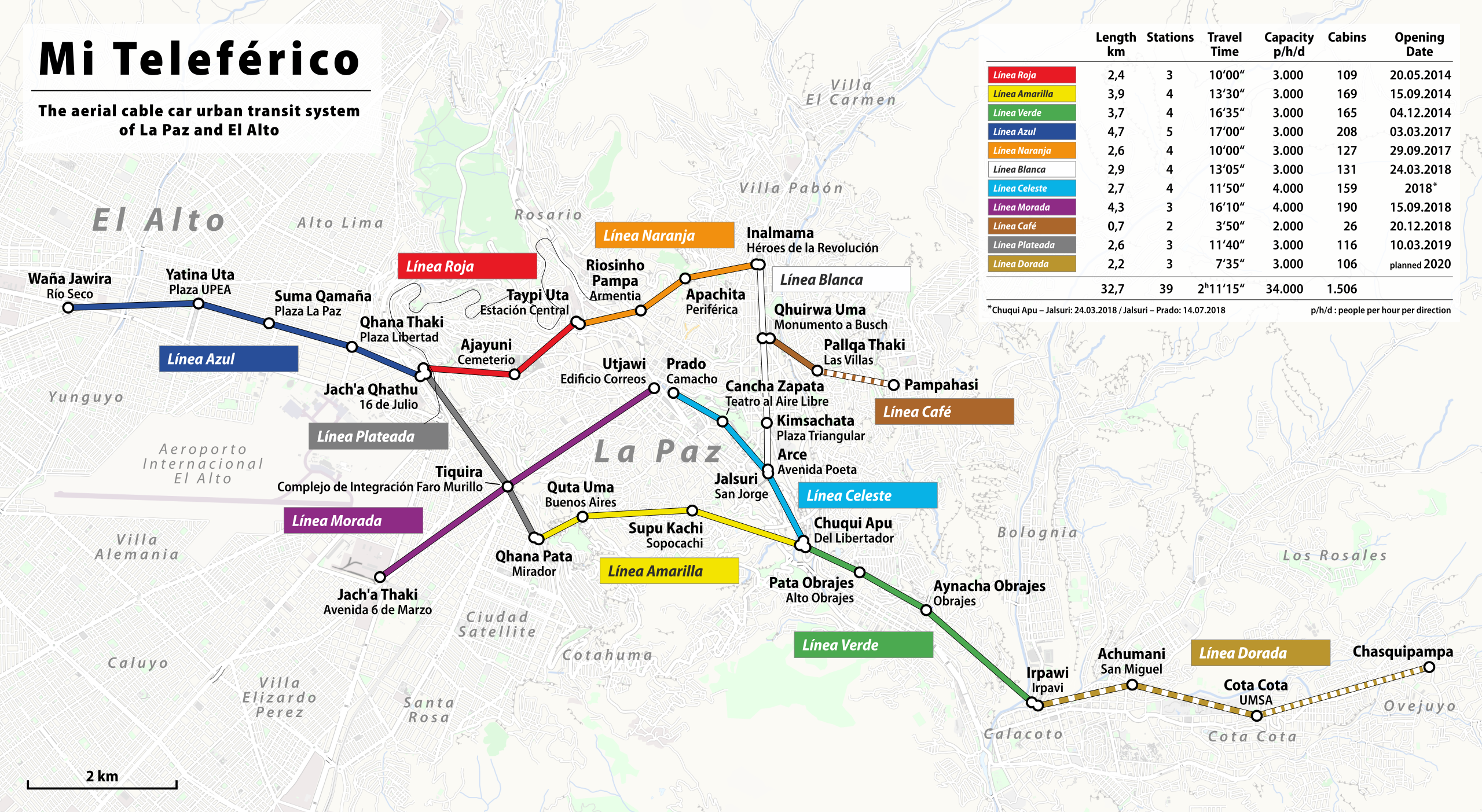
English: Map of Mi Teleférico, also known as Teleférico La Paz–El Alto, the aerial cable car urban transit system serving the La Paz–El Alto metropolitan area in Bolivia.
Français : Carte de Mi Teleférico, aussi connu sous le nom de téléphérique La Paz - El Alto, le réseau de téléphérique urbain desservant les villes de La Paz et El Alto, en Bolivie. |
||
| Date | 21 September 2014, 2018, 2019 | ||
| Source |
miteleferico.bo and others Geospatial data sources:
|
||
| Author | Chumwa; Michael F. Schönitzer; Chuq | ||
| Permission (Reusing this file) |
I, the copyright holder of this work, hereby publish it under the following licenses:
This file is licensed under the Creative Commons Attribution-Share Alike 3.0 Unported, 2.5 Generic, 2.0 Generic and 1.0 Generic license.
You may select the license of your choice. |

File history
Click on a date/time to view the file as it appeared at that time.
| Date/Time | Thumbnail | Dimensions | User | Comment | |
|---|---|---|---|---|---|
| current | 20:58, 20 May 2019 | | 2,784 × 1,525 (7.2 MB) | Chumwa | Linea plateada opened |
| 21:38, 20 January 2019 |  | 2,784 × 1,525 (6.59 MB) | Chumwa | update | |
| 06:07, 12 August 2018 |  | 2,784 × 1,525 (7.2 MB) | Chumwa | corr | |
| 06:05, 12 August 2018 |  | 2,784 × 1,525 (6.17 MB) | Chumwa | corr | |
| 05:53, 11 July 2018 |  | 2,784 × 1,525 (7.2 MB) | Chumwa | corr | |
| 20:40, 10 July 2018 |  | 2,784 × 1,525 (16.25 MB) | Chumwa | improvements, statistics | |
| 21:13, 13 June 2018 |  | 2,784 × 1,456 (15.84 MB) | Chumwa | added future extensions to Pampahasi und Chasquipampa | |
| 21:44, 12 June 2018 |  | 2,488 × 1,197 (15.68 MB) | Chumwa | some improvements | |
| 18:58, 10 June 2018 |  | 800 × 469 (358 KB) | MichaelSchoenitzer | Updated plan | |
| 18:32, 10 June 2018 |  | 800 × 469 (357 KB) | MichaelSchoenitzer | updated: white line opened |
File usage
The following pages on the English Wikipedia use this file (pages on other projects are not listed):
Global file usage
The following other wikis use this file:
- Usage on ar.wikipedia.org
- Usage on de.wikipedia.org
- Usage on es.wikipedia.org
- Usage on fr.wikipedia.org
- Usage on it.wikipedia.org
- Usage on ja.wikipedia.org
- Usage on no.wikipedia.org
- Usage on pl.wikipedia.org
- Usage on ru.wikipedia.org
- Usage on sv.wikipedia.org
- Usage on www.wikidata.org