
File:TDBank footprint.png

Size of this preview: 380 × 600 pixels. Other resolutions: 152 × 240 pixels | 304 × 480 pixels | 486 × 768 pixels | 1,114 × 1,758 pixels.
Original file (1,114 × 1,758 pixels, file size: 321 KB, MIME type: image/png)
| This is a file from the Wikimedia Commons. Information from its description page there is shown below. Commons is a freely licensed media file repository. You can help. |
Summary

|
|
Point Maps
══▻ FAQ ◅══ ══▻ Create your own ◅══ |
Licensing
This file is licensed under the Creative Commons Attribution-Share Alike 3.0 Unported license.
- You are free:
- to share – to copy, distribute and transmit the work
- to remix – to adapt the work
- Under the following conditions:
- attribution – You must give appropriate credit, provide a link to the license, and indicate if changes were made. You may do so in any reasonable manner, but not in any way that suggests the licensor endorses you or your use.
- share alike – If you remix, transform, or build upon the material, you must distribute your contributions under the same or compatible license as the original.
Original upload log
This image is a derivative work of the following images:
- File:Bahamas location map.svg licensed with Cc-by-sa-3.0, GFDL
- 2011-04-15T17:31:56Z NordNordWest 1559x1124 (391895 Bytes) upd
- 2008-10-23T19:17:05Z NordNordWest 1560x1125 (562379 Bytes) {{Information |Description= {{de|Positionskarte der [[:de:Bahamas|Bahamas]]}} Quadratische Plattkarte, N-S-Streckung 105 %. Geographische Begrenzung der Karte: * N: 27.5° N * S: 20.7° N * W: 80.7° W * O: 70.8° W {{en|Loca
- File:Canada New Brunswick location map.svg licensed with Cc-by-sa-3.0
- 2009-09-28T14:04:56Z NordNordWest 1411x1388 (511824 Bytes)
- 2009-08-25T17:55:19Z NordNordWest 1411x1388 (506982 Bytes) {{int:filedesc}} {{Information |Description= {{de|Positionskarte von [[:de:New Brunswick|New Brunswick]], [[:de:Kanada|Kanada]]}} Quadratische Plattkarte, N-S-Streckung 145 %. Geographische Begrenzung der Karte: * N: 48.3° N
- File:Canada Quebec location map.svg licensed with Cc-by-sa-3.0
- 2009-08-31T19:03:59Z NordNordWest 2316x2822 (2571526 Bytes) {{int:filedesc}} {{Information |Description= {{de|Positionskarte von [[:de:Québec|Québec]], [[:de:Kanada|Kanada]]}} Quadratische Plattkarte, N-S-Streckung 165 %. Geographische Begrenzung der Karte: * N: 62.8° N * S: 44.7°
- File:Canada Ontario location map.svg licensed with Cc-by-sa-3.0
- 2009-08-31T19:05:05Z NordNordWest 2032x2314 (1376421 Bytes)
- 2009-08-26T10:26:50Z NordNordWest 2032x2314 (1347915 Bytes) {{int:filedesc}} {{Information |Description= {{de|Positionskarte von [[:de:Ontario|Ontario]], [[:de:Kanada|Kanada]]}} Quadratische Plattkarte, N-S-Streckung 155 %. Geographische Begrenzung der Karte: * N: 57.1° N * S: 41.3°
- File:USA Maine location map.svg licensed with Cc-by-3.0, GFDL
- 2009-06-26T15:53:49Z Alexrk2 820x1250 (620502 Bytes) == Beschreibung == {{Information |Description= {{de|Positionskarte von [[:de:Maine|Maine]], [[:de:USA|USA]]}} Quadratische Plattkarte, N-S-Streckung 140.0 %. Geographische Begrenzung der Karte: * N: 47.7° N * S: 42.7° N * W
- File:USA New Hampshire location map.svg licensed with Cc-by-3.0, GFDL
- 2009-06-26T15:37:26Z Alexrk2 639x1120 (257053 Bytes) == Beschreibung == {{Information |Description= {{de|Positionskarte von [[:de:New Hampshire|New Hampshire]], [[:de:USA|USA]]}} Quadratische Plattkarte, N-S-Streckung 140.0 %. Geographische Begrenzung der Karte: * N: 45.5° N *
- File:USA Vermont location map.svg licensed with Cc-by-3.0, GFDL
- 2009-06-14T11:53:24Z Alexrk2 1277x2100 (265267 Bytes) minor enh
- 2009-06-14T11:17:38Z Alexrk2 1277x2100 (262625 Bytes) border lines
- 2009-06-13T18:32:56Z Alexrk 681x1120 (201506 Bytes) fixed border overlap
- 2009-06-13T16:23:33Z Alexrk 1022x1680 (102064 Bytes) fix international border
- 2009-06-13T16:05:37Z Alexrk 1022x1680 (103865 Bytes) == Beschreibung == {{Information |Description= {{de|Positionskarte von [[:de:Vermont|Vermont]], [[:de:USA|USA]]}} Quadratische Plattkarte, N-S-Streckung 140.0 %. Geographische Begrenzung der Karte: * N: 45.2° N * S: 42.5° N
- File:USA Massachusetts location map.svg licensed with Cc-by-3.0, GFDL
- 2009-07-05T11:13:36Z Alexrk2 1050x717 (249369 Bytes) resize
- 2009-06-25T19:38:19Z Alexrk2 800x546 (242956 Bytes) == Beschreibung == {{Information |Description= {{de|Positionskarte von [[:de:Massachusetts|Massachusetts]], [[:de:USA|USA]]}} Quadratische Plattkarte, N-S-Streckung 130.0 %. Geographische Begrenzung der Karte: * N: 43.1° N *
- File:USA Rhode Island location map.svg licensed with Cc-by-3.0, GFDL
- 2009-06-11T18:51:35Z NordNordWest 758x1021 (93024 Bytes) {{Information |Description= {{de|Positionskarte von [[:de:Rhode Island|Rhode Island]], [[:de:USA|USA]]}} Quadratische Plattkarte, N-S-Streckung 135 %. Geographische Begrenzung der Karte: * N: 42.2° N * S: 41.0° N * W: 72.1�
- File:USA Connecticut location map.svg licensed with Cc-by-3.0, GFDL
- 2009-06-25T19:16:48Z Alexrk2 800x678 (154250 Bytes) renderer bug
- 2009-06-25T19:14:39Z Alexrk2 800x678 (155149 Bytes) == Beschreibung == {{Information |Description= {{de|Positionskarte von [[:de:Connecticut|Connecticut]], [[:de:USA|USA]]}} Quadratische Plattkarte, N-S-Streckung 130.0 %. Geographische Begrenzung der Karte: * N: 42.3° N * S:
- File:USA New York location map.svg licensed with Cc-by-3.0, GFDL
- 2009-06-10T11:28:20Z NordNordWest 1572x1277 (597043 Bytes) {{Information |Description= {{de|Positionskarte vom Bundesstaat [[:de:New York (Bundesstaat)|New York]], [[:de:USA|USA]]}} Quadratische Plattkarte, N-S-Streckung 135 %. Geographische Begrenzung der Karte: * N: 45.3° N * S: 4
- File:USA New Jersey location map.svg licensed with Cc-by-3.0, GFDL
- 2009-06-17T19:59:27Z Alexrk2 839x1560 (259806 Bytes) enh
- 2009-06-13T18:01:16Z Alexrk 839x1560 (198653 Bytes) fixed SVG bug
- 2009-06-13T17:46:17Z Alexrk 839x1560 (246056 Bytes) == Beschreibung == {{Information |Description= {{de|Positionskarte von [[:de:New Jersey|New Jersey]], [[:de:USA|USA]]}} Quadratische Plattkarte, N-S-Streckung 130.0 %. Geographische Begrenzung der Karte: * N: 41.6° N * S: 38
- File:USA Pennsylvania location map.svg licensed with Cc-by-3.0, GFDL
- 2009-07-05T11:11:22Z Alexrk2 1201x805 (429769 Bytes) == Beschreibung == {{Information |Description= {{de|Positionskarte von [[:de:Pennsylvania|Pennsylvania]], [[:de:USA|USA]]}} Quadratische Plattkarte, N-S-Streckung 130.0 %. Geographische Begrenzung der Karte: * N: 42.7° N * S
- File:USA Delaware location map.svg licensed with Cc-by-3.0, GFDL
- 2009-06-22T10:54:18Z Alexrk2 470x800 (106507 Bytes) renderer bug
- 2009-06-22T10:39:54Z Alexrk2 470x800 (66078 Bytes) == Beschreibung == {{Information |Description= {{de|Positionskarte von [[:de:Delaware|Delaware]], [[:de:USA|USA]]}} Quadratische Plattkarte, N-S-Streckung 130.0 %. Geographische Begrenzung der Karte: * N: 40.0° N * S: 38.3°
- File:USA Maryland location map.svg licensed with Cc-by-3.0, GFDL
- 2009-06-22T11:30:38Z Alexrk2 1200x764 (463352 Bytes) fixed border
- 2009-06-22T11:23:05Z Alexrk2 1200x764 (459278 Bytes) crop height
- 2009-06-22T11:03:54Z Alexrk2 1201x955 (455501 Bytes) renderer bug
- 2009-06-22T10:42:06Z Alexrk2 800x636 (318450 Bytes) == Beschreibung == {{Information |Description= {{de|Positionskarte von [[:de:Maryland|Maryland]], [[:de:USA|USA]]}} Quadratische Plattkarte, N-S-Streckung 130.0 %. Geographische Begrenzung der Karte: * N: 40.3° N * S: 37.3°
- File:USA Virginia location map.svg licensed with Cc-by-3.0, GFDL
- 2009-07-06T18:02:25Z Alexrk2 1500x964 (963271 Bytes) resize
- 2009-06-26T16:42:40Z Alexrk2 1201x772 (966691 Bytes) == Beschreibung == {{Information |Description= {{de|Positionskarte von [[:de:Virginia|Virginia]], [[:de:USA|USA]]}} Quadratische Plattkarte, N-S-Streckung 130.0 %. Geographische Begrenzung der Karte: * N: 40.2° N * S: 35.8°
- File:USA North Carolina location map.svg licensed with Cc-by-3.0, GFDL
- 2010-04-25T12:44:25Z Alexrk2 1400x849 (1201046 Bytes) enh rivers, aligned state borders
- 2009-06-26T22:06:53Z Alexrk2 1400x849 (894030 Bytes) resize
- 2009-06-26T21:57:18Z Alexrk2 1400x849 (896940 Bytes) resize
- 2009-06-26T21:47:07Z Alexrk2 1201x728 (930560 Bytes) == Beschreibung == {{Information |Description= {{de|Positionskarte von [[:de:North Carolina|North Carolina]], [[:de:USA|USA]]}} Quadratische Plattkarte, N-S-Streckung 120.0 %. Geographische Begrenzung der Karte: * N: 37.5° N
- File:USA South Carolina location map.svg licensed with Cc-by-3.0, GFDL
- 2009-06-20T11:32:20Z Alexrk2 1200x978 (494031 Bytes) simpl water polygons
- 2009-06-20T11:30:37Z Alexrk2 1200x978 (499688 Bytes) simpl water polygons
- 2009-06-20T10:51:24Z Alexrk2 1200x978 (557792 Bytes) == Beschreibung == {{Information |Description= {{de|Positionskarte von [[:de:South Carolina|South Carolina]], [[:de:USA|USA]]}} Quadratische Plattkarte, N-S-Streckung 120.0 %. Geographische Begrenzung der Karte: * N: 35.4° N
- File:USA Georgia location map.svg licensed with Cc-by-3.0, GFDL
- 2009-06-20T11:26:27Z Alexrk2 1201x1384 (778454 Bytes) == Beschreibung == {{Information |Description= {{de|Positionskarte von [[:de:Georgia|Georgia]], [[:de:USA|USA]]}} Quadratische Plattkarte, N-S-Streckung 120.0 %. Geographische Begrenzung der Karte: * N: 35.2° N * S: 30.2° N
- File:USA Florida location map.svg licensed with Cc-by-3.0
- 2008-12-15T20:25:08Z Sting 1132x1096 (591820 Bytes) Counties boundaries: thinner strokes
- 2008-12-15T19:49:40Z Sting 1132x1096 (591829 Bytes) == Summary == {{Location|27|45|00|N|83|49|30|W|scale:4000000}} {{Information |Description={{en|Blank administrative map of the State of [[:en:Florida|Florida]], [[:en:United States|USA]], for geo-location purpose, with count
- File:USA West Virginia location map.svg licensed with Cc-by-3.0, GFDL
- 2009-07-03T15:31:49Z Alexrk2 1201x1118 (535137 Bytes) == Beschreibung == {{Information |Description= {{de|Positionskarte von [[:de:West Virginia|West Virginia]], [[:de:USA|USA]]}} Quadratische Plattkarte, N-S-Streckung 130.0 %. Geographische Begrenzung der Karte: * N: 40.8° N *
- File:USA Ohio location map.svg licensed with Cc-by-3.0, GFDL
- 2009-06-26T19:16:16Z Alexrk2 1010x1200 (465438 Bytes) == Beschreibung == {{Information |Description= {{de|Positionskarte von [[:de:Ohio|Ohio]], [[:de:USA|USA]]}} Quadratische Plattkarte, N-S-Streckung 130.0 %. Geographische Begrenzung der Karte: * N: 42.5° N * S: 38.2° N * W:
- File:USA Michigan location map.svg licensed with Cc-by-3.0, GFDL
- 2009-06-21T16:41:07Z Alexrk2 1066x1200 (657268 Bytes) Isle Royale
- 2009-06-21T11:39:57Z Alexrk2 1066x1200 (668111 Bytes) fixed borders
- 2009-06-21T11:30:04Z Alexrk2 1066x1200 (675974 Bytes) water lines
- 2009-06-21T11:21:34Z Alexrk2 1066x1200 (738759 Bytes) water lines
- 2009-06-21T11:02:31Z Alexrk2 1066x1200 (849542 Bytes) simp water polygons
- 2009-06-21T10:51:51Z Alexrk2 1066x1200 (860414 Bytes) == Beschreibung == {{Information |Description= {{de|Positionskarte von [[:de:Michigan|Michigan]], [[:de:USA|USA]]}} Quadratische Plattkarte, N-S-Streckung 140.0 %. Geographische Begrenzung der Karte: * N: 48.5° N * S: 41.5°
- File:USA Kentucky location map.svg licensed with Cc-by-3.0, GFDL
- 2009-09-03T14:45:55Z Alexrk2 1501x976 (842602 Bytes) == Beschreibung == {{Information |Description= {{de|Positionskarte von [[:de:Kentucky|Kentucky]], [[:de:USA|USA]]}} Quadratische Plattkarte, N-S-Streckung 130.0 %. Geographische Begrenzung der Karte: * N: 39.8° N * S: 35.8°
- File:USA Tennessee location map.svg licensed with Cc-by-3.0, GFDL
- 2009-06-20T10:17:47Z Alexrk2 1800x1068 (1214390 Bytes) page ratio, water bodies
- 2009-06-13T16:00:05Z Alexrk 1500x415 (251640 Bytes) == Beschreibung == {{Information |Description= {{de|Positionskarte von [[:de:Tennessee|Tennessee]], [[:de:USA|USA]]}} Quadratische Plattkarte, N-S-Streckung 120.0 %. Geographische Begrenzung der Karte: * N: 36.9° N * S: 34.8
The original description page was here. All following user names refer to en.wikipedia.
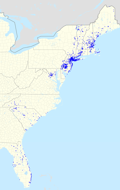
- 2010-10-01 20:56 Magog the Ogre 1106×1712× (526102 bytes) {{Information |Description= Footprint of [[TD Bank, N.A.]]. Zip codes with more than one branch have progressively larger points. |Source=I created this work entirely by myself; all US states and Canadian provinces in this image are derived from the corre
File history
Click on a date/time to view the file as it appeared at that time.
| Date/Time | Thumbnail | Dimensions | User | Comment | |
|---|---|---|---|---|---|
| current | 18:56, 19 August 2017 | | 1,114 × 1,758 (321 KB) | Magog the Ogre | 2017 update |
| 17:58, 1 February 2012 |  | 1,106 × 1,712 (514 KB) | File Upload Bot (Magnus Manske) | {{BotMoveToCommons|en.wikipedia|year={{subst:CURRENTYEAR}}|month={{subst:CURRENTMONTHNAME}}|day={{subst:CURRENTDAY}}}} {{Information |Description={{en|Footprint of en:TD Bank, N.A.. Zip codes with more than one branch have progressively larger poin |
File usage
The following pages on the English Wikipedia use this file (pages on other projects are not listed):
Global file usage
The following other wikis use this file:
- Usage on es.wikipedia.org
- Usage on fr.wikipedia.org