
File:Town Hall of North Hempstead 220 Plandome Rd jeh.jpg

Size of this preview: 800 × 533 pixels. Other resolutions: 320 × 213 pixels | 640 × 426 pixels | 1,024 × 682 pixels | 1,280 × 853 pixels | 2,100 × 1,399 pixels.
Original file (2,100 × 1,399 pixels, file size: 499 KB, MIME type: image/jpeg)
| This is a file from the Wikimedia Commons. Information from its description page there is shown below. Commons is a freely licensed media file repository. You can help. |
|
This is an image of a place or building that is listed on the National Register of Historic Places in the United States of America. Its reference number is 6001143. |
Summary
| Description |
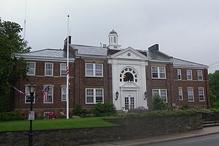
English: Looking southeast across Plandome Road at Town Hall on a rainy morning. |
| Date | Taken on 30 May 2011 |
| Source | Own work |
| Author | Jim.henderson |
| Camera location | | View this and other nearby images on: OpenStreetMap |
|---|
Licensing
I, the copyright holder of this work, hereby publish it under the following license:
| This file is made available under the Creative Commons CC0 1.0 Universal Public Domain Dedication. | |
| The person who associated a work with this deed has dedicated the work to the public domain by waiving all of their rights to the work worldwide under copyright law, including all related and neighboring rights, to the extent allowed by law. You can copy, modify, distribute and perform the work, even for commercial purposes, all without asking permission.
|
File history
Click on a date/time to view the file as it appeared at that time.
| Date/Time | Thumbnail | Dimensions | User | Comment | |
|---|---|---|---|---|---|
| current | 11:24, 15 August 2011 | | 2,100 × 1,399 (499 KB) | Jim.henderson |
File usage
No pages on the English Wikipedia use this file (pages on other projects are not listed).