File:USGS-PlanetMars-TopographicalMap.png
Page contents not supported in other languages.
This is a file from the Wikimedia Commons
From Wikipedia, the free encyclopedia

Original file(10,292 × 4,720 pixels, file size: 6.72 MB, MIME type: image/png)

Summary

Description
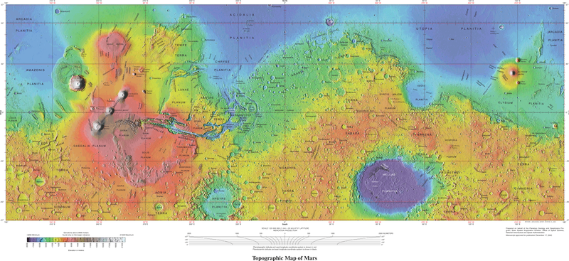
English: USGS - Planet Mars - Topographical Map - 1-24-2005 - Geologic Investigations Series I-2782
These maps are based on data from the Mars Orbiter Laser Altimeter (MOLA; Smith and others, 2001), an instrument on NASA’s Mars Global Surveyor (MGS) spacecraft (Albee and others, 2001). The image used for the base of this map represents more than 600 million measurements gathered between 1999 and 2001, adjusted for consistency (Neumann and others, 2001, 2003) and converted to planetary radii. These have been converted to elevations above the areoid as determined from a martian gravity field solution GMM-2B (Lemoine and others, 2001), truncated to degree and order 50, and oriented according to current standards (see below). The average accuracy of each point is originally ~100 meters in horizontal position and ~1 meter in radius (Neumann and others, 2001). However, the total elevation uncertainty is at least ±3 m due to the global error in the areoid (±1.8 meters according to Lemoine and others [2001]) and regional uncertainties in its shape (G.A. Neumann, written commun., 2002). The measurements were converted into a digital elevation model (DEM; G.A. Neumann, written commun., 2002; Neumann and others, 2001; Smith and others 2001) using Generic Mapping Tools software (Wessel and Smith, 1998), with a resolution of 0.015625 degree per pixel or 64 pixels per degree. In projection, the pixels are 926.17 meters in size at the equator. Data are very sparse near the two poles (above 87° north and below 87° south latitude) because these areas were sampled by only a few off-nadir altimetry tracks. Gaps between tracks of 1–2 km are common, and some gaps of up to 12 km occur near the equator. DEM points located in these gaps in MOLA data were filled by interpolation.
Date
Source https://pubs.usgs.gov/imap/i2782/; https://pubs.usgs.gov/imap/i2782/i2782_sh1.pdf
Author U.S. Geological Survey
Other versions

Licensing

Public domain
This image is in the public domain in the United States because it only contains materials that originally came from the United States Geological Survey, an agency of the United States Department of the Interior. For more information, see the official USGS copyright policy.

Bahasa Indonesia  català  čeština  Deutsch  eesti  English  español  français  galego  italiano  Nederlands  português  polski  sicilianu  suomi  Tiếng Việt  Türkçe  български  македонски  русский  മലയാളം  한국어  日本語  中文  中文(简体)  中文(繁體)  العربية  فارسی  +/−

Public domain This file is in the public domain in the United States because it was solely created by NASA. NASA copyright policy states that "NASA material is not protected by copyright unless noted". (See Template:PD-USGov, NASA copyright policy page or JPL Image Use Policy.)
Warnings:

Captions

Topographical map of Mars, encompassing latitudes 57°N to 57°S, produced by the USGS

Items portrayed in this file

depicts

File history

Click on a date/time to view the file as it appeared at that time.

Date/TimeThumbnailDimensionsUserComment
current18:11, 4 October 2021Thumbnail for version as of 18:11, 4 October 202110,292 × 4,720 (6.72 MB)Cherurbinosame 256 clr, larger size + legend
00:19, 16 May 2019Thumbnail for version as of 00:19, 16 May 20197,245 × 3,204 (11.38 MB)HuntsterCrop from original, manually trim out right side text, push title text up a bit.
02:14, 15 May 2019Thumbnail for version as of 02:14, 15 May 20193,472 × 1,544 (7.43 MB)DrbogdanUser created page with UploadWizard
The following pages on the English Wikipedia use this file (pages on other projects are not listed):

Global file usage

The following other wikis use this file:

Metadata