
Formignana
Formignana | |
|---|---|
| Comune di Formignana | |
.JPG) The central IV Novembre Square with the War Monument and the Saint Stephen church tower | |
Location of Formignana  | |
 Formignana Location of Formignana in Italy  Formignana Formignana (Emilia-Romagna) | |
| Coordinates: 44°51′N 11°52′E / 44.850°N 11.867°E | |
| Country | Italy |
| Region | Emilia-Romagna |
| Province | Province of Ferrara (FE) |
| Frazioni | Brazzolo |
| Area | |
| • Total | 22.3 km2 (8.6 sq mi) |
| Elevation | 3 m (10 ft) |
| Population (Dec. 2004)[2] | |
| • Total | 2,898 |
| • Density | 130/km2 (340/sq mi) |
| Time zone | UTC+1 (CET) |
| • Summer (DST) | UTC+2 (CEST) |
| Postal code | 44035 |
| Dialing code | 0533 |
| Patron saint | Saint Stephen I, Pope and Martyr |
| Website | Official website |
Formignana (Ferrarese: Furmgnàna) is a comune (municipality) in the Province of Ferrara in the Italian region Emilia-Romagna, located about 60 kilometres (37 mi) northeast of Bologna and about 20 kilometres (12 mi) east of Ferrara. As of 31 December 2004, it had a population of 2,898 and an area of 22.3 square kilometres (8.6 sq mi).[3]
Formignana borders the following municipalities: Copparo, Ferrara, Jolanda di Savoia, Tresigallo.
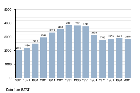
Demographic evolution[edit]
References[edit]
- ^ "Superficie di Comuni Province e Regioni italiane al 9 ottobre 2011". Italian National Institute of Statistics. Retrieved 16 March 2019.
- ^ "Popolazione Residente al 1° Gennaio 2018". Italian National Institute of Statistics. Retrieved 16 March 2019.
- ^ All demographics and other statistics: Italian statistical institute Istat.
External links[edit]
This article on a location in Emilia–Romagna is a stub. You can help Wikipedia by expanding it. |