
Gaya confederacy
Gaya confederacy 가야 (加倻) | |||||||||||
|---|---|---|---|---|---|---|---|---|---|---|---|
| 42–562 | |||||||||||
 Map showing the approximate location of selected Gaya polities relative to Silla and Baekje | |||||||||||
| Common languages | Gaya language (Part of Old Korean) | ||||||||||
| Religion | Buddhism, Korean shamanism | ||||||||||
| Government | Monarchy | ||||||||||
• 42–199 | Suro (first, Geumgwan) | ||||||||||
• ?-562 | Doseolji (last, Dae) | ||||||||||
| Historical era | Ancient | ||||||||||
• Establishment | 42 | ||||||||||
• Submission to Silla | 562 | ||||||||||
| |||||||||||
| Today part of | |||||||||||
| Gaya confederacy | |
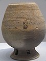
 Duck-shaped pottery from Gaya, 5th or 6th century. | |
| Korean name | |
|---|---|
| Hangul | 가야 |
| Hanja | |
| Revised Romanization | Gaya |
| McCune–Reischauer | Kaya |
| History of Korea |
|---|
 |
| Timeline |
|
|
Gaya (Korean: 가야; Hanja: 加倻; RR: Gaya, Korean pronunciation: [ka.ja]) was a Korean confederacy of territorial polities in the Nakdong River basin of southern Korea,[1] growing out of the Byeonhan confederacy of the Samhan period.
The traditional period used by historians for Gaya chronology is AD 42–532. According to archaeological evidence in the third and fourth centuries some of the city-states of Byeonhan evolved into the Gaya confederacy, which was later annexed by Silla, one of the Three Kingdoms of Korea. The individual polities that made up the Gaya confederacy have been characterized as small city-states.[2] The material culture remains of Gaya culture mainly consist of burials and their contents of mortuary goods that have been excavated by archaeologists. Archaeologists interpret mounded burial cemeteries of the late third and early fourth centuries such as Daeseong-dong in Gimhae and Bokcheon-dong in Busan as the royal burial grounds of Gaya polities.[3]
Names
Although most commonly referred to as Gaya (가야; 加耶, 伽耶, 伽倻; [kaja]), probably due to the imprecision of transcribing Korean words into hanja, historical sources use a variety of names, including Garak (가락; 駕洛, 迦落; [kaɾak]), Gara (가라; 加羅, 伽羅, 迦羅, 柯羅; [kaɾa]), Garyang (가량;加良; [kaɾjaŋ]), and Guya (구야; 狗耶; [kuja]).[4] According to Christopher I. Beckwith, "The spelling Kaya is the modern Korean reading of the characters used to write the name; the pronunciation /kara/ (transcriptionally *kala) is certain."[5]
In Japanese, Gaya is referred to as Mimana (任那), a name with considerable political connotations. However, a word kara (から, 韓 'Korea', 唐 '[Tang] China', 漢 '[Han] China'), which is probably from the name of Gaya on the Korean Peninsula of antiquity, has been preserved in Japanese with the sense "China or Korea, mainland East Asia" and, more recently, an even more vague sense of "the nations overseas, foreign country."[6]
History
According to a legend recorded in the Samguk Yusa written in the 13th century, in the year AD 42, six eggs descended from heaven with a message that they would be kings. Six boys were born, and within 12 days they grew mature. One of them, named Suro, became the king of Geumgwan Gaya, and the other five founded the remaining five Gayas, namely Daegaya, Seongsan Gaya, Ara Gaya, Goryeong Gaya, and Sogaya.[7]
The Gaya polities evolved out of the chiefly political structures of the twelve tribes of the ancient Byeonhan confederacy, one of the Samhan confederacies. The loosely organized chiefdoms resolved into six Gaya groups, centered on Geumgwan Gaya. On the basis of archaeological sources as well as limited written records, scholars such as Sin have identified the late 3rd century as a period of transition from Byeonhan to Gaya, with increasing military activity and changing funerary customs.[8] Sin[9] further argues that this was associated with the replacement of the previous elite in some principalities (including Daegaya) by elements from the Buyeo kingdom, who brought a more militaristic ideology and style of rule.
The Gaya Confederacy disintegrated under pressure from Goguryeo between AD 391 and 412, although the last Gaya polities remained independent until they were conquered by Silla in 562, as punishment for assisting Baekje in a war against Silla.
Economy
Polities were situated in the alluvial flats of tributary river valleys and the mouth of the Nakdong. In particular, the mouth of the Nakdong has fertile plains, direct access to the sea, and rich iron deposits. Gaya polities had economies that were based on agriculture, fishing, casting, and long-distance trade. They were particularly known for its iron-working, as Byeonhan had been before it. Gaya polities exported abundant quantities of iron ore, iron armor, and other weaponry to Baekje and the Kingdom of Wa in Yamato period Japan. In contrast to the largely commercial and non-political ties of Byeonhan, Gaya polities seem to have attempted to maintain strong political ties with those kingdoms as well.
Politics
Several ancient historical records list a number of polities of Gaya. For example, Goryeo Saryak (고려사략; 高麗史略) lists five: Geumgwan Gaya, Goryeong Gaya, Bihwa Gaya, Ara Gaya, and Seongsan Gaya.
The various Gaya polities formed a confederacy in the 2nd and 3rd centuries that was centered on the heartland of Geumgwan Gaya in modern Gimhae. After a period of decline, the confederacy was revived around the turn of the 5th and 6th centuries, this time centered on Daegaya of modern Goryeong. However, it was unable to defend itself against the incursions and attacks of the neighboring kingdom of Silla.
Mimana/Imna controversy
Political and trade relations with Japan have been a source of nationalist controversy in both Korea and Japan. Japanese publicists during the twentieth century looked to the Nihon Shoki, which claims that Gaya (named "Mimana" also "Kara" in Japanese) was a military outpost of Japan during the Yamato period (300–710). While there is no evidence to support this, the claim has nonetheless been advocated at various times by Japanese imperialists, nationalists and press to justify the Japanese colonial rule of Korea between 19th and 20th centuries.[10][11]
Archaeological evidence suggests that Gaya polities were the main exporter of technology and culture to Kyushu at that time. The theory of a Japanese outpost is widely rejected in Korea as there was no Japanese local groups at the time that had a strong enough military power to conquer Gaya or any other part of Korea.[12][13] The technology of Gaya was more advanced than that of the Japanese dynasties of the time.[12][13]
Gallery
-
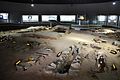 An exhibition of royal tomb of Daegaya. Goryeong, Gyeongsangbuk-do.
 -
 Gold crown and accessories.
 -
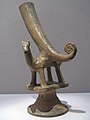 Horn-shaped cup from Gaya that may illustrate connection of Persian culture through the Silk Road to Korea.
 -
Gaya armour
-
 Gaya pottery at the National Museum of Korea.
 -
 Earthenwares display in Museum of Daegaya.
 -
 Shield ornaments excavated from the Daeseong-dong cemetery site in Gimhae.
 -
 This iron helmet illustrates the skill of iron-working and importance of iron from the Nakdong River valley.
 -
 Refinery model of Gaya people.
 -
 Gaya Crown
 -
 Earrings of Gaya.
 -
 A Gaya soldier


.jpg)
See also
- List of Korea-related topics
- History of Korea
- List of Korean monarchs#Gaya confederacy
- Three Kingdoms of Korea
- Crown of Gaya
- Relations between Kaya and ancient Japan
References
- ^ (2001). Kaya. In The Penguin Archaeology Guide, edited by Paul Bahn, pp. 228–229. Penguin, London.
- ^ Barnes, Gina L. (2001). Introducing Kaya History and Archaeology. In State Formation in Korea: Historical and Archaeological Perspectives, pp. 179–200. Curzon, London.
- ^ Barnes 2001:188–198.
- ^ Barnes 2001:182-184.
- ^ Beckwith, Christopher (2009). Empires of the Silk Road: A History of Central Eurasia from the Bronze Age to the Present. NJ: Princeton University Press. p. 105. ISBN 978-0-691-13589-2.
- ^ 『デジタル大辞泉』 "Digital Daijisen" (by 小学館/SHOGAKUKAN) at Goo Dictionary
- ^ Barnes 2001:180-182.
- ^ Sin, K.C. (2000). Relations between Kaya and Wa in the third to fourth centuries CE. Journal of East Asian Archaeology 2(3–4), 112–122.
- ^ Sin, K.C. (2000).
- ^ André Schmid (2002). Korea Between Empires: 1895 - 1919. Columbia University Press. ISBN 978-0-231-50630-4. Retrieved 31 July 2013.. Page 150, Page 169
- ^ Lee, Peter H & Wm. Theodore De Bary. Sources of Korean Tradition. Columbia University Press, 1997. ISBN 0-231-10567-3. Page 14
- ^ a b Kenneth B. Lee (1997). "4. Korea and Early Japan, 200 B.C. -700 A.D.". Korea and East Asia: The Story of a Phoenix. Greenwood Publishing Group. pp. 31 ~ 35p. ISBN 978-0-275-95823-7.
- ^ a b John Whitney Hall (1998). "5. Japan and the continent". The Cambridge History of Japan. Cambridge University Press. pp. 308 ~ 310p. ISBN 978-0-521-22352-2.