
Genesee River
Template:Geobox The Genesee River is an American river flowing northward through the Twin Tiers of Pennsylvania and New York. The river provided the original power for the Rochester area's 19th century mills and still provides hydroelectric power for downtown Rochester.
Geology
The Genesee is the remaining western branch of a preglacial system, with rock layers tilted an average of 40 feet (12 m) per mile. It begins in the Allegheny Plateau conglomerate, sandstone, and shale rocks of the Mississippian and Pennsylvanian subperiods. The river also often exposes older rocks such as shales (some rich in hydrocarbons), siltstones and some limestones of the Devonian period at Letchworth[specify] and, at a canyon with three more Niagara Escarpment waterfalls at Rochester, limestones and shales of Silurian age.
History
The preglacial eastern branch of the Genesee runs south of Mount Morris and was completely diverted by extensive terminal moraines just south of Dansville, so most of the upper section[clarification needed] was diverted toward the Susquehanna River system. Now only a small creek flows in what is left of this large valley.
The Seneca nation traditionally lived between the Genesee River and Canandaigua Lake. The region was surveyed by Thomas Davies in 1766. The High Falls was then also known as the Great Seneca Falls and the Genesee river was also called the Casconchiagon river.[1]
If "not for hydropower, the flour mills, clothing mills, and tool fabricators would not have located in Rochester",[2] and the 1825 Erie Canal allowed the mills to ship products to New York City. A few hundred feet north of the center of the village of Rochester, the Erie Canal crossed the Genesee River via a 1823 stone aqueduct (802 feet (244 m) long, 17 feet (5.2 m) wide), which was replaced by the 1842 Erie Canal: Second Genesee Aqueduct.
Most of New York west of the Genesee River was part of the Holland Purchase after the American Revolution. The river demarcates the "Genesee Country" of New York to the west[citation needed] and the Finger Lakes geographic region to the east.
On Friday, November 13, 1829 (Friday the 13th), the daredevil Sam Patch jumped to his death before 8,000 spectators at the Upper Falls in Rochester.
In 1836 the Genesee Valley Canal was begun to build a new canal from the Erie Canal near Rochester, up the Genesee Valley, across to the Allegheny River at Olean. Construction of new sections extended upriver (southward) until 1880. Although an important commercial route, the canal was plagued by frequent flood damage and the final leg down the Allegany River was never completed. The most difficult section to build was the bypass around the gorge and falls at present day Letchworth Park. The canal followed the old Native American portage route, which necessitated many locks. These old locks can still be seen near Nunda. The project was abandoned and the right of way was sold in 1880. The property became the roadbed for the Genesee Valley Canal Railroad, which eventually merged with the Pennsylvania Railroad. Much of the canal and railroad right-of-way is open to the public today as the Genesee Valley Greenway, which was started in 1991.
In 1852 a wooden railroad bridge was built over the Upper Falls at Portageville. It was the largest of all wooden bridges built at the time.[citation needed] The wood from 300 acres (1.2 km²) of trees was required for its timber. In the "summer of 1943", Arch Merrill walked the length of the Genesee River.[3]
Floods
A March 1865 thaw was the worst Genesee flood in Rochester history, and a similar 1913 flood motivated the excavation of the Genesee's rock bed in Downtown Rochester. The 1972 Hurricane Agnes flood broke all county historical records, with the most concentrated damage in the Wellsville area.[4][5] The water from Hurricane Agnes caused the only instance where the river's flow exceeded the storage capacity of the reservoir of the Mount Morris Dam, the largest flood control dam east of the Mississippi, and water had to be released from the dam to prevent overtopping of the spillway.
Gallery
-
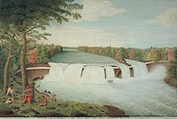 A View of the Casconchiagon or Great Seneca Falls, Lake Ontario, taken 1766 by Thomas Davies
 -
 The High Falls in downtown Rochester
 -
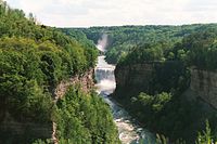 The Middle Falls in Letchworth State Park


Crossings
References
- ^ Harris, George H. (1892). "Notes on the Aboriginal Terminology of the Genesee River". Publications. Rochester Historical Society. p. 11.
- ^ Baily, Rod (1984). "Sources of Energy in Rochester's History" (PDF). Rochester History. XLVI (3–4). Rochester Public Library. ISSN 0035-7413. Retrieved 2009-12-29.
Hydropower has never contributed more than two and a half percent of the total energy supply of Rochester
{{cite journal}}: Unknown parameter|month=ignored (help) - ^ Merrill, Arch (1943). "A River Ramble: Saga of the Genesee Valley". GenWeb Monroe County, NY. Retrieved 2009-11-26.
{{cite web}}: External link in|publisher=
- (see also: "Rediscovering the Rambling River". Democrat and Chronicle. tbd. Retrieved tbd.
{{cite web}}: Check date values in:|accessdate=and|date=(help))
- (see also: "Rediscovering the Rambling River". Democrat and Chronicle. tbd. Retrieved tbd.
- ^ "HURRICANE AGNES and the GENESEE RIVER FLOODING". NWS Eastern Region Headquarters. Retrieved 2009-12-18.
{{cite web}}: Cite has empty unknown parameter:|coauthors=(help) - ^ "The great flood of 1972". Star-Gazette. Elmira, New York: Gannett. 1972. p. 63.
{{cite news}}: Cite has empty unknown parameter:|coauthors=(help)
External links