
Geography of Georgia (country)
Georgia is situated in Southwestern Asia, bordering the Black Sea, between Turkey and Russia. Located in the region known as the Caucasus or Caucasia, Georgia is a small country of approximately 69,875 km²— about the size of West Virginia. To the north and northeast, Georgia borders the Russian republics of Chechnya, Ingushetia, and North Ossetia (all of which began to seek autonomy from Russia in 1992). Neighbors to the south are Armenia, Azerbaijan, and Turkey. The shoreline of the Black Sea constitutes Georgia's entire western border.
Geographic coordinates: 42°00′N 43°30′E / 42.000°N 43.500°E
Topography


Despite its small area, Georgia has one of the most varied topographies of the former Soviet republics. Georgia lies mostly in the Caucasus Mountains, and its northern boundary is partly defined by the Greater Caucasus range. The Lesser Caucasus range, which runs parallel to the Turkish and Armenian borders, and the Surami and Imereti ranges, which connect the Greater Caucasus and the Lesser Caucasus, create natural barriers that are partly responsible for cultural and linguistic differences among regions. Because of their elevation and a poorly developed transportation infrastructure, many mountain villages are virtually isolated from the outside world during the winter. Earthquakes and landslides in mountainous areas present a significant threat to life and property. Among the most recent natural disasters were massive rock- and mudslides in Ajaria in 1989 that displaced thousands in southwestern Georgia, and two earthquakes in 1991 that destroyed several villages in northcentral Georgia and South Ossetia.
Georgia has about 25,000 rivers, many of which power small hydroelectric stations. Drainage is into the Black Sea to the west and through Azerbaijan to the Caspian Sea to the east. The largest river is the Mtkvari (formerly known by its Azerbaijani name, Kura, which is still used in Azerbaijan), which flows 1,364 km from northeast Turkey across the plains of eastern Georgia, through the capital, Tbilisi, and into the Caspian Sea. The Rioni River, the largest river in western Georgia, rises in the Greater Caucasus and empties into the Black Sea at the port of Poti. Soviet engineers turned the river lowlands along the Black Sea coast into prime subtropical agricultural land, embanked and straightened many stretches of river, and built an extensive system of canals. Deep mountain gorges form topographical belts within the Greater Caucasus.
Climate
Georgia's climate is affected by subtropical influences from the west and Mediterranean influences from the east. The Greater Caucasus range moderates local climate by serving as a barrier against cold air from the north. Warm, moist air from the Black Sea moves easily into the coastal lowlands from the west. Climatic zones are determined by distance from the Black Sea and by altitude. Along the Black Sea coast, from Abkhazia to the Turkish border, and in the region known as the Kolkhida Lowlands inland from the coast, the dominant subtropical climate features high humidity and heavy precipitation (1000 to 2000 mm per year; the Black Sea port of Batumi receives 2500 mm per year). Several varieties of palm trees grow in these regions, where the midwinter average temperature is 5 °C and the midsummer average is 22 °C.
The plains of eastern Georgia are shielded from the influence of the Black Sea by mountains that provide a more continental climate. Summer temperatures average 20 to 24 °C, winter temperatures 2 to 4 °C. Humidity is lower, and rainfall averages 500 to 800 mm per year. Alpine and highland regions in the east and west, as well as a semi-arid region on the Iori Plateau to the southeast, have distinct microclimates.
At higher elevations, precipitation is sometimes twice as heavy as in the eastern plains. In the west, the climate is subtropical to about 650 m; above that altitude (and to the north and east) is a band of moist and moderately warm weather, then a band of cool and wet conditions. Alpine conditions begin at about 2100 m, and above 3600 m snow and ice are present year-round.
Environmental issues
Beginning in the 1980s, Black Sea pollution has greatly harmed Georgia's tourist industry. Inadequate sewage treatment is the main cause of that condition. In Batumi, for example, only 18 percent of wastewater is treated before release into the sea. An estimated 70 percent of surface water contains health-endangering bacteria to which Georgia's high rate of intestinal disease is attributed.
The war in Abkhazia did substantial damage to the ecological habitats unique to that region. In other respects, experts considered Georgia's environmental problems less serious than those of more industrialized former Soviet republics. Solving Georgia's environmental problems was not a high priority of the national government in the post-Soviet years, however; in 1993 the minister for protection of the environment resigned to protest this inactivity. In January 1994, the Cabinet of Ministers announced a new, interdepartmental environmental monitoring system to centralize separate programs under the direction of the Ministry of Protection of the Environment. The system would include a central environmental and information and research agency. The Green Party used its small contingent in the parliament to press environmental issues in 1993.
Natural hazards: earthquakes
Environment - current issues: air pollution, particularly in Rust'avi; heavy pollution of Mtkvari River and the Black Sea; inadequate supplies of potable water; soil pollution from toxic chemicals
Environment - international agreements:
party to:
Air Pollution, Biodiversity, Climate Change, Climate Change-Kyoto Protocol, Desertification, Endangered Species, Hazardous Wastes, Law of the Sea, Ozone Layer Protection, Ship Pollution, Wetlands
signed, but not ratified:
none of the selected agreements
Area and boundaries
Area:
total:
69,700 km²
land:
69,700 km²
water:
0 km²
Area - comparative: slightly smaller than South Carolina (US) or Benelux (EU)
Land boundaries:
total:
1,461 km
border countries:
Armenia 164 km, Azerbaijan 322 km, Russia 723 km, Turkey 252 km
Coastline: 310 km
Maritime claims: NA
Elevation extremes:
lowest point:
Black Sea 0 m
highest point:
Mt'a Shkhara 5201 m (peak is not in Georgia)
Mt'a Mq'invartsveri (Gora Kazbeg) at 5048 m is the highest peak in Georgia.
Resources and land use
Natural resources: forests, hydropower, manganese deposits, iron ore, copper, minor coal and petroleum deposits; coastal climate and soils allow for important tea and citrus growth
Land use:
arable land:
9%
permanent crops:
4%
permanent pastures:
25%
forests and woodland:
34%
other:
28% (1993 est.)
Irrigated land: 4,000 km² (1993 est.)
Gallery of Georgia
-
 4th Century Jvari Church
 -
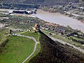
 Gremi Church
 -
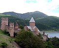 10th Century Ananuri Church
 -
 Kakheti vineyards
 -
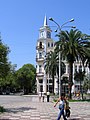
 Tbilisi
 -
 Gagra
Gagra -
 Sukhumi
 -
Medieval fortress of Varzia
-
 Bakuriani
 -
 Northern Georgia
 -
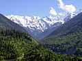
 River valleys in the Caucasus
 -
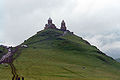 14th Century Gergeti Sameba Church
 -
 Mountain landscape


See also
References

This image is available from the United States Library of Congress Prints and Photographs Division under the digital ID {{{id}}}
This tag does not indicate the copyright status of the attached work. A normal copyright tag is still required. See Wikipedia:Copyrights for more information.
 This article incorporates public domain material from The World Factbook. CIA.