Hà Tĩnh
Appearance
Hà Tĩnh | |
|---|---|
City | |
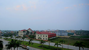
 View from Sailing Tower building | |
| Country | |
| Province | Hà Tĩnh |
| Upgraded to city | 28 May 2007 |
| Government | |
| • People's Committee President | Trần Thế Dũng |
| • People's Association President | Đậu Thị Thủy |
| Area | |
• Total | 5,619 km2 (2,170 sq mi) |
| Population | 117.546 |
| Climate | Am |
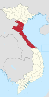
Hà Tĩnh () is a city in Vietnam.[1] It is the capital of the Hà Tĩnh Province, and lies in North Central Coast region. It is located on the National Highway 1A. The Vietnamese capital Hanoi is located 340 km north from Hà Tĩnh; 50 km north from it the city Vinh is located; Hue city is located 314 km south. Hà Tĩnh is 12.5 km away from the South China Sea.
- North borders: Town Thạch Hà (via Cày bridge), Cửa Sót river.
- West borders: Thạch Đài Commune, Cày river (Thạch Hà district).
- Southern borders: Cẩm Bình Commune, Cẩm Vịnh Commune (Cẩm Xuyên district).
- Eastern borders: Đồng Môn river (Thạch Hà district, Lộc Hà)
Gallery
-
City Cultural Center
References
- ^ Atlas of the World, Oxford University Press, 2011, p. 236.


