
Hoy, Orkney
| Old Norse name | Há-øy[1] |
|---|---|
| Meaning of name | Old Norse for 'high island'[1] |
| Location | |
 | |
| OS grid reference | ND263961 |
| Physical geography | |
| Island group | Orkney |
| Area | 14,318 hectares (55.3 sq mi)[1] |
| Area rank | 12 [2] |
| Highest elevation | Ward Hill 479 metres (1,572 ft) |
| Administration | |
| Sovereign state | United Kingdom |
| Country | Scotland |
| Council area | Orkney Islands |
| Demographics | |
| Population | 272 |
| Population rank | 28 [2] |
| Largest settlement | Lyness |
| References | [1][3][4][5][6][7] |
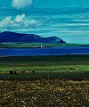
Hoy (from Norse Háey meaning high island) is an island in Orkney, Scotland. With an area of 143 square kilometres (55 sq mi) it is the second largest in the archipelago after the Mainland. It is connected by a causeway called The Ayre to South Walls. Unusually, the two islands are treated as one entity by the UK census.[8]
Description
The dramatic coastline of Hoy greets visitors travelling to Orkney by ferry from the Scottish mainland. It has extremes of many kinds: some of the highest sea cliffs in the UK at St John's Head, which reach 350 metres (1,150 ft);[1] the impressive and famous sea stack, the Old Man of Hoy; some of the most northerly surviving natural woodland in the British Isles and the remote possibility that the Orkney charr (Salvelinus inframundus), last described in 1908, survive in Heldale Water.[9] The most northerly Martello Towers were built to defend the area during the Napoleonic War, but were never used in combat.
The highest point in Orkney, Ward Hill, is found on Hoy.
The main naval base for the British fleet Scapa Flow in both the First and Second World Wars was situated at Lyness in the south-east of the island. Some rather incongruous Art Deco structures nearby date from this period.
An unusual rock-cut tomb, the Dwarfie Stane, lies in the Rackwick valley in the north of the island. It is unique in northern Europe, bearing similarity to Neolithic or Bronze Age tombs around the Mediterranean. The tomb gets its name as it is very small and was said to be carved by dwarves.
In Norse mythology, Hoy is the location of the never-ending battle between Hedin and Högni.
Orkney Ferries serve the island with two routes, one of which links Lyness on Hoy and Longhope on Walls with the island of Flotta and Houton on the Orkney Mainland. The other route links Moaness in Hoy to the island of Graemsay and Stromness on Orkney Mainland.
Hoy is part of the Hoy and West Mainland National Scenic Area, one of 40 in Scotland.[10]
Wildlife
The northern part of the island is an RSPB reserve due to its importance for birdlife, particularly Great skuas and red-throated divers. It was sold to the RSPB by the Hoy Trust for a minimal amount.[11] Anastrepta orcadensis, a liverwort also known as Orkney Notchwort, was first discovered on Ward Hill by William Jackson Hooker in 1808.[12][13]
In pop culture
Hoy is featured prominently in the 1984 video for "Here Comes The Rain Again" by Eurythmics.
Gallery
-
 Cliffs on the Atlantic coast of Hoy, south of Rackwick
 -
 The Old Man of Hoy, seen from the south
 -
 Scapa Flow Visitor Centre
 -
 Hoy High Lighthouse on Graemsay viewed from Mainland
 -
 Rackwick valley
 -
 Rackwick


References
- ^ a b c d e Haswell-Smith, Hamish (2004). The Scottish Islands. Edinburgh: Canongate. pp. 344–6. ISBN 978-1-84195-454-7.
- ^ a b Area and population ranks: there are c. 300 islands over 20 ha in extent and 93 permanently inhabited islands were listed in the 2011 census.
- ^ 2001 UK Census per List of islands of Scotland
- ^ Orkney Placenames
- ^ Ordnance Survey
- ^ Anderson, Joseph (Ed.) (1893) Orkneyinga Saga. Translated by Jón A. Hjaltalin & Gilbert Goudie. Edinburgh. James Thin and Mercat Press (1990 reprint). ISBN 0-901824-25-9
- ^ Pedersen, Roy (January 1992) Orkneyjar ok Katanes (map, Inverness, Nevis Print)
- ^ General Register Office for Scotland (28 November 2003) Occasional Paper No 10: Statistics for Inhabited Islands.
- ^ IUCN Red List
- ^ "National Scenic Areas". SNH. Retrieved 30 Mar 2011.
- ^ Haswell-Smith, Hamish (1996). The Scottish Islands. Canongate. p. 283. ISBN 0-86241-579-9.
- ^ "Bryology (mosses, liverworts and hornworts)" Royal Botanic Garden Edinburgh. Retrieved 15 May 2008.
- ^ "West Highland Mosses And Problems They Suggest" (January 1907) Annals Of Scottish Natural History 61 p. 46. Edinburgh. Retrieved 11 June 2008.
External links
58°51′N 3°18′W / 58.850°N 3.300°W
|  | ||||||||||||||||
|
| |||||||||||||||||
| |||||||||||||||||
| |||||||||||||||||
| |||||||||||||||||
| |||||||||||||||||
| |||||||||||||||||
| |||||||||||||||||