
Imphal
Imphal | |
|---|---|
City | |
 Imphal Location of Imphal in Manipur  Imphal Imphal (India) | |
| Coordinates: 24°48′27″N 93°56′18″E / 24.8074°N 93.9384°E | |
| Country | India |
| State | Manipur |
| District | Imphal East, Imphal West |
| Elevation | 786 m (2,579 ft) |
| Population (2011 census) | |
| • Total | 264,986 (village) 414,288 (Metropolitan area)[1] |
| Languages | |
| • Official | Meeteilon (Manipuri) and English |
| Time zone | UTC+5:30 (IST) |
| PIN | 795001 |
| Telephone code | 3852 |
| Vehicle registration | MN-01 |
| Website | www |
Imphal (ɪm'fɑl ) is the capital city of the Indian state of Manipur. Ruins of the Palace of Kangla, the royal seat of the erstwhile Kingdom of Manipur, are in the city centre, surrounded by a moat.
History
The Battle of Imphal took place between March and July 1944, during World War II.[2]
Demographics
The Imphal metropolitan area is made up of Bijoy Govinda, Chingangbam Leikai, Imphal, Khongman, Khurai Sajor Leikai, Kiyamgei, Kongkham Leikai (portion), Laipham Siphai, Lairikyengbam Leikai, Lamjaotongba, Lamshang (core town), Langjing, Langthabal Kunja, Langthabal Mantrikhong (portion), Lilong (Imphal West) (core town), Lilong (Thoubal), Naorem Leikai, Naoria Pakhanglakpa, Oinam Thingel, Porompat, Porompat Plan Area, Pangei, Sagolband (portion), Takyel Mapal, Thongju and Torban (Kshetri Leikai).[1]
Geography and climate
| Imphal | ||||||||||||||||||||||||||||||||||||||||||||||||||||||||||||
|---|---|---|---|---|---|---|---|---|---|---|---|---|---|---|---|---|---|---|---|---|---|---|---|---|---|---|---|---|---|---|---|---|---|---|---|---|---|---|---|---|---|---|---|---|---|---|---|---|---|---|---|---|---|---|---|---|---|---|---|---|
| Climate chart (explanation) | ||||||||||||||||||||||||||||||||||||||||||||||||||||||||||||
| ||||||||||||||||||||||||||||||||||||||||||||||||||||||||||||
| ||||||||||||||||||||||||||||||||||||||||||||||||||||||||||||
Imphal is located at 24°48′27″N 93°56′18″E / 24.8074°N 93.9384°E in extreme eastern India,[4] with an average elevation of 786 metres (2,579 ft). It has a humid subtropical climate (Köppen Cwa)[5] with mild, dry winters and a hot monsoon season. July temperatures average about 29 °C (84 °F); January is the coldest month, with average lows near 4 °C (39 °F). The city receives about 1,320 mm (52 in) of rain, with June the wettest month. The highest recorded temperature was 35.6 °C (96.1 °F), on 22 May 2009, and the lowest temperature was −2.7 °C (27.1 °F) on 10 January 1970.[3][6]
| Climate data for Imphal | |||||||||||||
|---|---|---|---|---|---|---|---|---|---|---|---|---|---|
| Month | Jan | Feb | Mar | Apr | May | Jun | Jul | Aug | Sep | Oct | Nov | Dec | Year |
| Record high °C (°F) | 27.8 (82.0) |
31.5 (88.7) |
35.0 (95.0) |
34.4 (93.9) |
35.6 (96.1) |
35.6 (96.1) |
35.7 (96.3) |
34.0 (93.2) |
34.4 (93.9) |
33.5 (92.3) |
30.7 (87.3) |
28.9 (84.0) |
35.7 (96.3) |
| Mean daily maximum °C (°F) | 21.7 (71.1) |
23.4 (74.1) |
26.9 (80.4) |
28.4 (83.1) |
28.9 (84.0) |
29.4 (84.9) |
29.0 (84.2) |
29.2 (84.6) |
29.0 (84.2) |
28.4 (83.1) |
25.4 (77.7) |
22.4 (72.3) |
26.9 (80.4) |
| Daily mean °C (°F) | 14.5 (58.1) |
16.3 (61.3) |
20.0 (68.0) |
22.7 (72.9) |
24.1 (75.4) |
24.6 (76.3) |
24.5 (76.1) |
24.6 (76.3) |
24.4 (75.9) |
22.8 (73.0) |
19.0 (66.2) |
15.6 (60.1) |
21.1 (70.0) |
| Mean daily minimum °C (°F) | 4.3 (39.7) |
7.2 (45.0) |
11.6 (52.9) |
15.7 (60.3) |
18.4 (65.1) |
21.2 (70.2) |
21.5 (70.7) |
21.3 (70.3) |
20.1 (68.2) |
16.6 (61.9) |
11.0 (51.8) |
5.3 (41.5) |
14.6 (58.3) |
| Record low °C (°F) | −2.7 (27.1) |
−1.4 (29.5) |
2.4 (36.3) |
6.2 (43.2) |
11.1 (52.0) |
14.7 (58.5) |
15.4 (59.7) |
14.6 (58.3) |
14.3 (57.7) |
7.8 (46.0) |
1.5 (34.7) |
−1.7 (28.9) |
−2.7 (27.1) |
| Average precipitation mm (inches) | 11.7 (0.46) |
30.8 (1.21) |
91.6 (3.61) |
132.7 (5.22) |
158.6 (6.24) |
224.9 (8.85) |
222.8 (8.77) |
194.8 (7.67) |
147.3 (5.80) |
111.5 (4.39) |
46.0 (1.81) |
15.1 (0.59) |
1,387.7 (54.63) |
| Average precipitation days | 1.2 | 3.3 | 6.6 | 9.8 | 11.5 | 15.3 | 15.7 | 13.0 | 9.9 | 6.8 | 3.1 | 1.0 | 97.2 |
| Source 1: IMD (period: 1971–2000, record low and high up to 2010)[3][6] | |||||||||||||
| Source 2: Climate-Data.org for mean temperatures (altitude: 779m)[5] | |||||||||||||
Tourist attractions
Kangla
-
 Bamboo huts in Kangla Fort complex
 -
 Kangla Fort Complex
 -
 Ruins of Kangla Fort
 -
 Kangla Museum houses
.jpeg)

.jpeg)
.jpeg)
Kangla Fort is on the banks of the Imphal River, and is also known as the Palace of Kangla. Kangla means "dry land" in the Meitei language. The fort was the palace of King Pakhangba, and also has religious significance. In the fort are a number of temples, and it is surrounded on three sides by a lake.[citation needed]
Hiyangthang Lairembi Temple Complex
A religious site and a tourist attraction, the temple complex is noted for its annual Durga Puja festival in September or October.

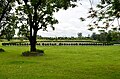
This cemetery remembers British and Indian soldiers who fought and died in the Second World War (1944).
Women's Market (Ima Keithel)
The market stalls are all run by women, and it is reportedly the only such market in the world.[7]
.jpeg)
Transport
Air

Imphal International Airport is 8 kilometres (5.0 mi) south of the city which connects direct flights to New Delhi, Kolkata, Guwahati and Agartala. [8]
Road
.jpeg)
Imphal is connected through National Highway which connects major cities like Guwahati, Kohima, Agartala and many more and also connects its neighbour states.
Railway
In October 2012, India's Cabinet Committee on Infrastructure approved an extension of the Jiribam-Silchar railway to Imphal. The extension is expected to reach the city by Q4 of 2019.[9][10]
The total length of the Jiribam-Tupul railway line is 110.62 km and the total revised estimated cost is Rs 9658 crore. So far, Rs 4927.65 crore has been spent. The Ministry has set a target of sanctioning Rs 1000 crore within the current financial year in order to speed up the railway construction work.
Sports
Khuman Lampak Main Stadium is the multi-purpose stadium in Imphal, India. It is used mostly for football and athletics. The stadium holds 30,000 people and was built in 1999. This stadium lies inside the Khuman Lampak Sports Complex. The professional football club NEROCA FC of I League is based in Imphal and they use Khuman Lampak Main Stadium as their home ground.
E-connectivity
Mobile networks
Shopping and markets
Imphal is developing itself for business and markets. Supermakets and shopping malls in Imphal include:
- Thangal bazar
- Paona bazar
- lamphel supermarket
- Pishumthong bazar
- Singjamei Bazar
- Kakwa Bazar
- Kwakeithel Bazar
- Mamas supermarket
- Sigma Bazaar Supermarket
- Gaurahi Shopping Complex
- MAMCY Mall
- Olympia Mall
- Vishal mega mart
- Bazar India
- Kumecs City Centre
Education
Universities

- Manipur Central University[11]
- Central Agricultural University
- National Sports University
- Manipur University of Culture
Technical colleges
- Indian Institute of Information Technology, Manipur
- Manipur Institute of Technology
- National Institute of Technology, Manipur[12]
- Manipur Technical University[13]
Medical colleges

Schools
There are many schools in imphal affiliated from C.B.S.E and ICSE Board, as well as state government schools.
- 9 Jawahar Navodaya Vidyalaya including Khumbong (Imphal west), Imphal east, Bishnupur, CCpur, Ukrul, Thoubal, Tamenglong and Senapati
- Don Bosco, Imphal
- St. Paul's School
- St Anthony's school Imphal
- Dav public school
- Areca school
- Sainik school imphal
- Kendriya vidyalaya No 1 Imphal
- Lodestar public school
- Sangai higher secondary school
- Little flower school
- Manipur public school
- St Joseph school
- Guru nanak public school
- Johnstone higher secondary school
- Herbert school
- Sanfort school Imphal
Media
Newspapers
- The Sangai Express
- Poknapham
- ICHEL Express
- Imphal Free Press
- Naharlogi Thoudang
- Hueiyen Lanpao Newspaper
- Manipur Mail
News channels
- Istv news Manipur
- Impact tv
Healthcare
Imphal is facilitated with many private and government hospitals which are open 24 hours and provide all required facilities.
- Regional institute of Medical sciences
- Shija Hospitals & Research Institutes
- City Hospital
- Imphal hospital
- Raj medicity
- Sky hospital and research Institute
- Mother's care hospital and research centre
- Apex hospital
- Jawahar lal nehru institute of Medical sciences
- Horizon hospital and research Institute
References
- ^ a b Census2011.co.in. 2011. Retrieved 2011-09-30.
- ^ "Imphal and Kohima". Britain's Greatest Battles. National Army Museum. Archived from the original on 7 February 2015. Retrieved 9 January 2016.
{{cite web}}: Unknown parameter|deadurl=ignored (|url-status=suggested) (help) - ^ a b c "Imphal, India". India Meteorological Department. Retrieved 16 May 2014.
- ^ "Maps, Weather, and Airports for Imphal, India". Retrieved 10 June 2015.
- ^ a b "Climate: Imphal - Climate graph, Temperature graph, Climate table". Climate-Data.org. Retrieved 31 October 2013.
- ^ a b "Ever Recorded Maximum Temperature, Minimum Temperature and 24 Hours Heaviest Rainfall upto 2010" (PDF). India Meteorological Department. Archived from the original (PDF) on 21 May 2013. Retrieved 16 May 2014.
{{cite web}}: Unknown parameter|deadurl=ignored (|url-status=suggested) (help) - ^ "Ima Keithel – A market by women". She. msn. Archived from the original on 15 June 2013. Retrieved 25 November 2012.
{{cite web}}: Unknown parameter|deadurl=ignored (|url-status=suggested) (help) - ^ "Imphal". Airports Authority of India. Retrieved 25 November 2012.
- ^ "Govt approves rail link to Imphal". The Indian Express. 26 October 2012. Retrieved 25 November 2012.
- ^ "NFR – Jiribam-Imphal Rail Line – Manipur". Construction Intelligence Centre. Retrieved 7 November 2017.
- ^ "Manipur University". Retrieved 10 June 2015.
- ^ "Welcome To NIT Manipur". Retrieved 10 June 2015.
- ^ "MTU". mtu.ac.in. Retrieved 25 February 2017.
- ^ "Regional Institute of Medical Sciences". Retrieved 28 January 2014.
- ^ "JNIMS". Archived from the original on 22 November 2010. Retrieved 28 January 2014.
{{cite web}}: Unknown parameter|dead-url=ignored (|url-status=suggested) (help)
External links
 Imphal travel guide from Wikivoyage
- Imphal West
- Imphal East
| International | |
|---|---|
| National | |