Indre, Loire-Atlantique
Appearance
Indre
| |
|---|---|
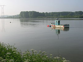
 The Loire at Basse-Indre | |
| Coordinates: 47°11′58″N 1°40′12″W / 47.1994°N 1.67°W | |
| Country | France |
| Region | Pays de la Loire |
| Department | Loire-Atlantique |
| Arrondissement | Nantes |
| Canton | Saint-Herblain-1 |
| Intercommunality | Nantes Métropole |
| Government | |
| • Mayor (2020–2026) | Anthony Berthelot[1] |
Area 1 | 4.72 km2 (1.82 sq mi) |
| Population (2021)[2] | 4,130 |
| • Density | 880/km2 (2,300/sq mi) |
| Time zone | UTC+01:00 (CET) |
| • Summer (DST) | UTC+02:00 (CEST) |
| INSEE/Postal code | 44074 /44610 (Basse-Indre and Haut-indre), 44620 (Indret) |
| Dialling codes | 02 |
| 1 French Land Register data, which excludes lakes, ponds, glaciers > 1 km2 (0.386 sq mi or 247 acres) and river estuaries. | |
Indre (French pronunciation: [ɛ̃dʁ] ; Gallo: Aendr, Breton: Antr or Endrez) is a commune in the Loire-Atlantique department in western France.
Etymology
[edit]The name Indre, pronounced [ɛ̃dʁ] in French, derives from that of Latin Antrum. The city was called Antrum and Antrinse monasterium in 840, Andra in 1144 was renamed Aindre and Indre.
The inhabitants of Indre are known in French as indrais .
Administration
[edit]Mayors
[edit]| Term | Name | Party |
|---|---|---|
| Mathurin Buet | ||
| ?- 1812 - ? | Pierre Fauluy | |
| 1871[5] | Victor Boquien | |
| 1876–1907 | Victor Boquien | |
| 1907–1908 | Jules Dupuy | |
| 1908–? | Joseph Déjoie | |
| 1921–? | Henri Michel | |
| 1968–1977 | Félix Guyot | SFIO |
| 2001–2006 | Alcide Maquaire | PS |
| 2006–2014 | Jean-Luc Le Drenn | DVG |
| 2014–2020 | Serge David | DVG |
| 2020–incumbent | Anthony Berthelot | DVG |
Population
[edit]
|
| ||||||||||||||||||||||||||||||||||||||||||||||||||||||
| Source: EHESS[6] and INSEE (1968-2017)[7] | |||||||||||||||||||||||||||||||||||||||||||||||||||||||
Sights
[edit]See also
[edit]References
[edit]- ^ "Répertoire national des élus: les maires" (in French). data.gouv.fr, Plateforme ouverte des données publiques françaises. 13 September 2022.
- ^ "Populations légales 2021" (in French). The National Institute of Statistics and Economic Studies. 28 December 2023.
- ^ francegenweb.org, List of mayors of Indre
- ^ "La Culture pour tous - Délibérations municipales". Archived from the original on 24 March 2009. Retrieved 26 June 2009.
- ^ (in French)Répertoire général de bio-bibliographie bretonne - editor J. Plihon - René Pocard du Cosquer de Kerviler, Louis Marie Chauffier
- ^ Des villages de Cassini aux communes d'aujourd'hui: Commune data sheet Indre, EHESS (in French).
- ^ Population en historique depuis 1968, INSEE
Wikimedia Commons has media related to Indre (Loire-Atlantique).


