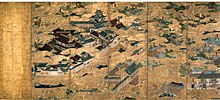
Jurakudai
This article includes a list of references, related reading, or external links, but its sources remain unclear because it lacks inline citations. (August 2014) |

The Jurakudai or Jurakutei (聚楽第) was a lavish palace constructed at the order of Toyotomi Hideyoshi in Kyoto, Japan. Construction began in 1586, when Hideyoshi had taken the post of kanpaku, and required 19 months. The location is in present-day Kamigyō, on the site where the Imperial palace had stood in the Heian period.
Hideyoshi moved to Jurakudai from Osaka Castle following completion, just after his victory over the Shimazu family in Kyūshū. He made it the base for his administration.
In 1588, Hideyoshi held a lavish entertainment of the reigning Emperor Go-Yōzei before the assembled daimyo. He also met Tokugawa Ieyasu here. He provided quarters for Sen no Rikyu within the grounds, and hosted the famous Great Kitano Tea Ceremony in nearby Kitano in 1587.
Hideyoshi resigned the post of Kanpaku in 1591, and his nephew Toyotomi Hidetsugu assumed the position, taking residence at Jurakudai. Hidetsugu hosted a second visit by the same emperor. In 1594, construction began on Hideyoshi's new Fushimi Castle, and when, in 1595, Hidetsugu was forced to commit seppuku, the Jurakudai was dismantled, with many parts being reassembled at Fushimi Castle.
Said to have had gold leaf on the roofing tiles, the Jurakudai was extremely lavish. Although it was a residential palace, it had defensive ramparts and moats typical of a castle. Some buildings of the Jurakudai survive, among them the Hiun-kaku at Nishi Hongan-ji, the Karamon at Daitoku-ji, and the front gate at Myōkaku-ji (all in Kyoto).
Recent excavations have yielded some tiles bearing gold leaf.
External links
![]() Media related to Jurakudai at Wikimedia Commons
Media related to Jurakudai at Wikimedia Commons
- Discovery of tiles (in Japanese)
