
Kōrankei
| Kōrankei Gorge | |
|---|---|
 Kōrankei Valley, 2019 | |
 Location of Kōrankei  Kōrankei (Japan) | |
| Location | Toyota, Aichi, Japan |
| Coordinates | 35°07′54.63″N 137°18′48.13″E / 35.1318417°N 137.3133694°E |
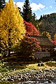
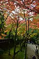
Kōrankei (Japanese: 香嵐渓) is a gorge created by the Yodo River, a tributary of the Yahagi River. It is a part of Asuke Town, Toyota City, Aichi Prefecture. Kōrankei has over 4000 maple trees[1] said to have been planted in 1634.[2] It sits next to Aichi Kōgen Quasi-National Park, and is a popular tourist destination, famous for its autumn foliage and its Erythronium japonicum flowers.[3]
Background[edit]

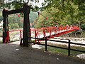
In 1634, Kazuhisa Sanei, the 11th head priest of Kōjakuji Temple, is said to have planted maple and cedar trees in Asuke, on the approach from Yodogawa to Kasuji. Many maples have, since then, been planted by residents. It is said that 11 different types of maple trees have been planted at Korankei.[2][4] A walking path has been built around the North side of the river valley. The Taigetsukyo bridge (Japanese: 待月橋) was named the symbol of the river in 1953. After three changes, the bridge was finally settled on as a symbol in 2007.[citation needed]
In 1930, when the priest and hamlet mayor were asked by Osaka Mainichi Shimbun about the naming, the answer given was "From Iimori-yama hill comes a balmy breeze, going over the Tomoegawa, and through Seifu on the approach to Kozaku-ji. It brings a fragrant climax, called 'Korankei'."[5]
The maple trees of Kōrankei change colors in autumn, [1] and are normally in full bloom from mid-November to late-November. The Momiji Festival is held every November, with multiple ceremonies and parades.[6] Shaping the river valley is the 254-meter tall Iimori-yama Mountain, with a 15-minute climb to the top. At the top is an observatory dedicated to Operation Raleigh (Japan phase) venturers in their visit to the town on May 15, 1987.[citation needed]
Transportation[edit]
Heavy traffic normally occurs on National Route 153 in the center of Asuke (for about 10 kilometers, according to Tokai TV program "Style Plus"). In March 2008, the Asuke Bypass started to be partially used to remedy traffic problems that started in 2007, so that cars would be able to bypass the center of Kōrankei to get to their destinations. Kōrankei is about a 65-minute drive via Meitetsu Bus from Higashi-Okazaki Station.[2] Visitors from Kanto and Kansai can go via Route 153 from the Tomei Expressway.[7]
Gallery[edit]
-
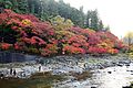 Autumn Leaves in Kōrankei Gorge
 -
 Autumn leaves of Korankei
 -
 Autumn leaves of Korankei
 -
 Sanshu Asuke Yashiki
 -
 Kōjakuji Temple grounds
 -
 Kōjakuji Temple
 -
 Koranashi Bridge


References[edit]
- ^ a b "Korankei Momiji Festival – Tourism of ALL JAPAN x TOKYO". www.tourism-alljapanandtokyo.org. Retrieved 18 November 2019.
- ^ a b c "Korankei Gorge | Japan Highlights Travel, for sightseeing around Tokaido". japan-highlightstravel.com. Archived from the original on 3 July 2017. Retrieved 18 November 2019.
- ^ "Korankei Gorge | JAPAN MOUNTAINS Story | Welcome to the SHORYUDO". go-centraljapan.jp. Retrieved 2019-11-18.
- ^ "Korankei Valley Autumn Leaves | Aichi Attractions | Travel Japan | JNTO". Japan National Tourism Organization (JNTO). Retrieved 18 November 2019.
- ^ "Introducing Korankei". city.toyota.aichi.jp.
- ^ "Korankei - Kikuko-Nagoya". Archived from the original on 2018-11-18. Retrieved 2019-11-14.
- ^ "第64回 香嵐渓もみじまつり". 豊田市足助観光協会. Archived from the original on 5 December 2018. Retrieved 18 November 2019.
External links[edit]
- "Asuke Tourism Association".
- "Toyota City Tourism Association".
- "AICHI NOW - Korankei". Aichi Official Tourist Guide.