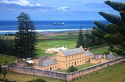
Kingston and Arthur's Vale Historic Area
Appearance
| Kingston and Arthur's Vale Historic Area | |
|---|---|
 | |
 | |
| Type | Historic Area |
| Location | Quality Row, Kingston, southern side of Norfolk Island |
| Coordinates | 29°03′12″S 167°57′31″E / 29.05333°S 167.95861°E[1] |
| Status | Australian National Heritage List World Heritage list |
| Website | http://www.kavha.gov.nf/# |
Kingston and Arthurs Vale Historic Area is an old settlement on the Kingston coastal plains (bounded by hills), southern side of Norfolk Island, consisting of a large group of buildings from the British Empire's convict era (1788-1855), now considered to be of such cultural significance to Australia and to the World that the area has been formally inscribed onto both the Australian National Heritage List[2] and UNESCO's World Heritage list[3] as amongst:
" .. the best surviving examples of large-scale convict transportation and the colonial expansion of European powers through the presence and labour of convicts."[4]
See also
- Australian Convict Sites
- Norfolk Island first penal settlement
- Norfolk Island second penal settlement
External links
References
- ^ a b Chapter 1 of Australian Government's "Australian Convict Sites" World Heritage nominationAccessed 5 August 2010
- ^ Australian Department of Environment, Water, Heritage and the Arts "National Heritage: Kingston and Arthurs Vale Historic Area (KAVHA), Norfolk Island" webpageAccessed 4 August 2010
- ^ Australia's Department of Environment, Heritage, Water and the Arts "World Heritage: Australian Convict Sites" webpageAccessed 2 August 2010
- ^ UNESCO's World Heritage "Australian Convict Sites" webpagesAccessed 2 August 2010
