
Lake Chelan
| Lake Chelan | |
|---|---|
| Location | Chelan County, Washington, United States |
| Coordinates | 47°50′28″N 120°02′47″W / 47.84111°N 120.04639°W |
| Type | Fjord |
| Primary inflows | Stehekin River, Railroad Creek |
| Primary outflows | Chelan River |
| Catchment area | 924 sq mi (2,390 km2) |
| Basin countries | United States |
| Max. length | 50.5 mi (81.3 km) |
| Surface area | 52.1 sq mi (135 km2) |
| Average depth | 474 ft (144 m) |
| Max. depth | 1,486 ft (453 m) |
| Water volume | 15,800,000 acre-feet (1.95×10¹⁰ m3) |
| Residence time | 10.6 years |
| Shore length1 | 109.2 mi (175.7 km) |
| Surface elevation | 1,100 ft (340 m) |
| Settlements | see #Cities |
| References | [1][2] |
| 1 Shore length is not a well-defined measure. | |
Lake Chelan is a narrow, 50.5 miles (81.3 km) long lake in Chelan County, north-central Washington state, U.S.[1] It is the largest natural lake in the state by any measure. With the completion of Lake Chelan Dam in 1927, the elevation of the lake was raised up to 21 feet (6.4 m).[2] Two cities lie on the southern end of the lake, and a third town sits at the far north end, providing a gateway to the North Cascades National Park.
Name
The name Chelan is a Salish Indian word, "Tsi - Laan," meaning 'Deep Water'.[4]
Hydrology
On an annual basis, an average of 2,200 cfs flow into the lake.[5] Approximately seventy-five percent of the water that flows into the lake comes from two tributaries.[6] The Stehekin River alone contributes 65% of all water to Lake Chelan, averaging 1,041 cfs annually.[5][7] The other major tributary, Railroad Creek, averages 202 cfs annually.[5] The remaining water is added via a number of smaller tributaries as well as direct rain and snowfall.
With a maximum depth of 1,486 feet (453 m),[5] Lake Chelan is the third deepest lake in the United States, and the 26th deepest in the world. At its deepest, the lake bottom is 388 feet (118 m) below sea level.[8] The total watershed of the lake is a modest 924 square miles (2,390 km2)[6][9][10] More than 90% of the watershed is forested land. The remainder of the basin is composed of the lake itself (5.6%) and agriculture (3.5%).[11]
Geography
Basins
Lake Chelan is composed of two basins. The lower basin, Wapato, is shallower and approximately a fourth the total length of the lake. The upper basin, Lucerne, is much deeper and extends for the remainder of the length of the lake. The two basins are separated by a sill rising to within 122 feet of the surface, at a point known as the narrows, at which the lake is only 0.35 miles (0.56 km) wide.[8] The two basins were created by two independent glaciers that met and then formed the sill when they retreated.[7] First, the Chelan glacier came down from the Stehekin valley and scoured the valley, potentially as far as the Columbia River. Later, the Okanogan lobe came up the Chelan Valley as far as Wapato Point. As the Okanogan lobe retreated, it left huge amounts of debris in the valley originally scoured by the Chelan glacier.[12]
Wapato Basin
The lower basin, Wapato, is the shallower of the two, with a maximum depth of only 400 feet (120 m). About 600 feet (180 m) of glacial sediment and rockslide deposits rest between the lake bottom and bedrock.[13] This section of the lake is 12 miles (19 km) long, and has an average depth of 190 feet (58 m).[12]
Due to the relatively modest size of this basin, water resides in this basin for only 0.8 years, compared to 10 for Lucerne Basin.[14]
Lucerne Basin
Lucerne basin, 38 miles (61 km) long with an average depth of 1,148 feet (350 m), is by far the larger of the two basins.[12] It is in this part of the lake that the maximum depth of 1,486 feet (453 m) is found. Lucerne basin contains 92% of the water in Lake Chelan and 74% of the surface area, leaving Wapato with only 8% of the total volume of water and 26% of the surface area.[7][8][13]
The upper basin of Lake Chelan is surrounded by mountainous terrain, resulting in few beaches along the shoreline. Approximately 50 miles (80 km) of the shoreline of this basin are in National Forest lands, and 12 miles (19 km) in National Park lands.[7]
Climate
The climate of Lake Chelan's watershed is varied. From the southern end of the lake in the rain shadow of the Cascade Range, to the northern tip of the lake located in the eastern Cascades, the climate of Lake Chelan's watershed is as diverse as the lake is long. The south end's weather is notably dry, with Chelan averaging only 11.4 inches (29 cm) of rain per year, along with 21.8 inches (55 cm) of snow. Stehekin receives an average of 35.5 inches (90 cm) of rain per year, and {{convert|122.5|in|cm} of snow. Other than precipitation trends, the climates are remarkably similar. Both locations average around 60 °F (16 °C) for a high, and 40 °F (4 °C) for a low throughout the course of the year.
| Climate data for Chelan, Washington (south end of lake) | |||||||||||||
|---|---|---|---|---|---|---|---|---|---|---|---|---|---|
| Month | Jan | Feb | Mar | Apr | May | Jun | Jul | Aug | Sep | Oct | Nov | Dec | Year |
| Record high °F (°C) | 62 (17) |
63 (17) |
72 (22) |
88 (31) |
98 (37) |
102 (39) |
106 (41) |
105 (41) |
97 (36) |
88 (31) |
72 (22) |
65 (18) |
106 (41) |
| Mean daily maximum °F (°C) | 33.2 (0.7) |
40.2 (4.6) |
51.0 (10.6) |
61.2 (16.2) |
70.0 (21.1) |
76.6 (24.8) |
85.3 (29.6) |
85.2 (29.6) |
76.1 (24.5) |
61.5 (16.4) |
44.3 (6.8) |
34.0 (1.1) |
59.9 (15.5) |
| Mean daily minimum °F (°C) | 24.3 (−4.3) |
26.8 (−2.9) |
33.6 (0.9) |
41.0 (5.0) |
48.7 (9.3) |
56.0 (13.3) |
62.0 (16.7) |
60.9 (16.1) |
52.1 (11.2) |
41.7 (5.4) |
32.0 (0.0) |
25.9 (−3.4) |
42.1 (5.6) |
| Record low °F (°C) | −14 (−26) |
−11 (−24) |
4 (−16) |
23 (−5) |
28 (−2) |
33 (1) |
35 (2) |
42 (6) |
26 (−3) |
15 (−9) |
−3 (−19) |
−18 (−28) |
−18 (−28) |
| Average precipitation inches (mm) | 1.61 (41) |
1.35 (34) |
0.81 (21) |
0.66 (17) |
1.01 (26) |
0.85 (22) |
0.40 (10) |
0.31 (7.9) |
0.28 (7.1) |
0.83 (21) |
1.37 (35) |
1.92 (49) |
11.4 (291) |
| Average snowfall inches (cm) | 7.1 (18) |
3.2 (8.1) |
0.8 (2.0) |
0 (0) |
0 (0) |
0 (0) |
0 (0) |
0 (0) |
0 (0) |
0 (0) |
1.7 (4.3) |
9.0 (23) |
21.8 (55.4) |
| Source: NOAA[15] | |||||||||||||
| Climate data for Stehekin, Washington (north end of lake) | |||||||||||||
|---|---|---|---|---|---|---|---|---|---|---|---|---|---|
| Month | Jan | Feb | Mar | Apr | May | Jun | Jul | Aug | Sep | Oct | Nov | Dec | Year |
| Record high °F (°C) | 55 (13) |
59 (15) |
70 (21) |
88 (31) |
101 (38) |
103 (39) |
107 (42) |
105 (41) |
98 (37) |
84 (29) |
67 (19) |
62 (17) |
107 (42) |
| Mean daily maximum °F (°C) | 33.5 (0.8) |
38.7 (3.7) |
47.7 (8.7) |
58.8 (14.9) |
68.7 (20.4) |
75.7 (24.3) |
85.3 (29.6) |
84.2 (29.0) |
74.1 (23.4) |
57.5 (14.2) |
41.2 (5.1) |
33.1 (0.6) |
58.2 (14.6) |
| Mean daily minimum °F (°C) | 18.6 (−7.4) |
21.7 (−5.7) |
30.4 (−0.9) |
38.0 (3.3) |
44.1 (6.7) |
51.2 (10.7) |
58.7 (14.8) |
58.1 (14.5) |
50.5 (10.3) |
36.4 (2.4) |
26.8 (−2.9) |
19.3 (−7.1) |
37.8 (3.2) |
| Record low °F (°C) | −18 (−28) |
−16 (−27) |
−5 (−21) |
19 (−7) |
25 (−4) |
30 (−1) |
36 (2) |
30 (−1) |
22 (−6) |
16 (−9) |
0 (−18) |
−11 (−24) |
−18 (−28) |
| Average precipitation inches (mm) | 6.43 (163) |
3.67 (93) |
2.98 (76) |
1.63 (41) |
1.13 (29) |
0.79 (20) |
0.55 (14) |
0.63 (16) |
0.98 (25) |
3.46 (88) |
6.80 (173) |
6.45 (164) |
35.5 (902) |
| Average snowfall inches (cm) | 41.3 (105) |
19.7 (50) |
8.4 (21) |
0.2 (0.51) |
0 (0) |
0 (0) |
0 (0) |
0 (0) |
0 (0) |
0.0 (0.0) |
10.9 (28) |
42.0 (107) |
122.5 (311.51) |
| Source: NOAA[15] | |||||||||||||
Cities
Owing to the isolated nature of Lake Chelan, especially in its upper reaches, there is not a large population that resides along the shore. Presently, there are only two incorporated cities along the shores of Lake Chelan. Incorporated cities on the shores of Lake Chelan include:
In addition to these two cities, one unincorporated town is located on the far northern reach of the lake. With approximately 75[18] residents, Stehekin serves as a gateway to North Cascades National Park. At the mouth of the Railroad Creek sits Lucerne, a small community of private cabins served by commercial boats.[19]
Recreation
Fishing
Fishing is a popular recreating activity on Lake Chelan. The following fish are or were native to the lake: Bull Trout, Westslope cutthroat trout, Largescale sucker, Longnose sucker, Bridgelip sucker, Northern pikeminnow, Peamouth, Redside shiner, Mountain whitefish, Pygmy whitefish.[20][21]
In addition to these native species, six species have been introduces to the lake, primarily for sport fishing purposes: Yellowstone cutthroat trout, Rainbow trout, Kokanee, Brook trout, Chinook salmon, Lake trout)[20][21]
State Records
There is currently one state record fish that was pulled from Lake Chelan. In 2013, a 35.63 pounds (16.16 kg) Lake Trout was caught, setting the state record.[22]
Protected Lands
At the north end of the lake, surrounding the town of Stehekin, is Lake Chelan National Recreation Area. Surrounding much of the lake on either side is Wenatchee National Forest. Two state parks are located on the southern edge, not far from the city of Chelan. These state parks are Twenty-Five Mile Creek State Park and Lake Chelan State Park.[23]
In addition to the protected land located directly on the shores of Lake Chelan, Stehekin serves not only as a gateway to the Lake Chelan NRA, but also to to the rest of the North Cascades National Park Complex, Stephen Mather Wilderness, and adjacent National Forest Wilderness Areas.[24] Approximately 87% of the Lake Chelan watershed is owned by either federal, state, or local entities, with the rest in private ownership.[11]
Notable Achievements
In 2011, Emily von Jentzen became the first person to swim the length of Lake Chelan, finishing in 36 hours.[25][26] She performed the feat to raise money for Katelyn Roker, a young girl battling stage-4 neuroblastoma.[26]
On July 11, 2014, Lake Chelan was crossed via standup paddleboard (SUP) from Stehekin to Chelan in 13 hours, 30 minutes by Matt Parker and Joe Walker. It was the first such crossing. They left the Stehekin River at 7:15 AM on July 11, 2014 and touched dry land at Campbell's Resort in Chelan, WA at 8:45 PM that same day. They traveled via 14' SUP boards.[27]
Images
-
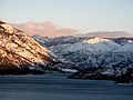
 Lake Chelan as seen from the southern shore off United States Highway 97.
 -
 View of Manson orchards from the south shore of Lake Chelan
 -
 View uplake from the south shore of Lake Chelan
 -
 View of Lake Chelan from Lakeshore trail, near Stehekin
 -
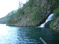 Domke Falls is the best known waterfall that drops into the lake


References
- ^ a b "TMDL Case Study: Lake Chelan, Washington". Environmental Protection Agency. January 1994. Retrieved 2015-01-17.
- ^ a b Kendra, Will; Singleton, Lynn (January 1987). "Morphometry of Lake Chelan" (PDF). Washington State Department of Ecology. Retrieved 2015-01-17.
- ^ BioAnalysts, Inc (February 2000). "Historical Occurrences of Anadromous Salmonids in Lake Chelan, Washington" (PDF). Retrieved 2015-01-13.
- ^ "Native American Legends" (PDF). USDA Forest Service - Pacific Northwest Region. Retrieved 2007-06-26. [dead link]
- ^ a b c d "Chelan Watershed Initial Assessment" (PDF). Washington Department of Ecology. May 1985. Retrieved 2015-01-13. Cite error: The named reference "watershed" was defined multiple times with different content (see the help page).
- ^ a b Hillman, T.W.; Giorgi, A.E. (February 2000). "Historical Occurrences of Anadromous Salmonids in Lake Chelan, Washington" (PDF). Chelan Public Utilities District. BioAnalysts, Inc. Retrieved 2015-01-17.
- ^ a b c d Coots, Randy (June 2006). "Lake Chelan Watershed DDT and PCB Total Maximum Daily Load: Water Quality Improvement Report" (PDF). Washington State Department of Ecology. Retrieved 2015-01-19.
- ^ a b c "Lake Chelan Wapato Basin Total Phosphorus Total Maximum Daily Load" (PDF). State of Washington Department of Ecology. November 2011. Retrieved 2015-01-18.
- ^ "Chelan Watershed Initial Assessment" (PDF). Washington Department of Ecology. May 1985. Retrieved 2015-01-13.
- ^ "Water Quality Improvement Project: Lake Chelan Area: Multi-Parameter". Department of Ecology - State of Washington. March 2013. Retrieved 2015-01-17.
- ^ a b "Draft In-Leau Fee Program Prospectus and Compensation Planning Framework for Lower Lake Chelan" (PDF). The Watershed Company. June 2010. Retrieved 2015-01-19.
- ^ a b c Chamberlain, William; Singleton, Lynn; Jay, Joe (1985-02-20). "Lake Chelan Project Proposal" (PDF). Washington State Department of Ecology. Retrieved 2015-01-19.
- ^ a b "Discover Lake Chelan" (PDF). National Park Service. Retrieved 2015-01-14.
- ^ Pelletier, Greg; Owes, Harper (January 1989). "Lake Chelan Water Quality Assessment" (PDF). Washington State Department of Ecology. Retrieved 2015-01-19.
- ^ a b "NowData – NOAA Online Weather Data". National Oceanic and Atmospheric Administration. Retrieved January 17, 2015.
- ^ U.S. Census Bureau. "Chelan City, Washington". Retrieved 2015-01-13.
- ^ U.S. Census Bereau. "Manson CDP, Washington". Retrieved 2015-01-13.
- ^ Visit Stehekin. "Visit Stehekin, Washington". Retrieved 2015-01-13.
- ^ "Shoreline Inventory" (PDF). Chelan County. 2012-04-23. Retrieved 2015-01-19.
- ^ a b Nelson, Mark C. (2012-01-20). "What Happened to Bull Trout in Lake Chelan? An Examination of the Historical Evidence" (PDF). U.S. Fish and Wildlife Service. Retrieved 2015-01-17.
- ^ a b Hillman, T.W.; Giorgi, A.E. (February 2000). "Historical Occurrences of Anadromous Salmonids in Lake Chelan, Washington" (PDF). Chelan Public Utilities District. BioAnalysts, Inc. Retrieved 2015-01-17.
- ^ "Freshwater and Saltwater Records". Washington Department of Fish & Wildlife. Retrieved 2015-01-17.
- ^ "Lake Chelan Area State Parks Management Plan". Washington State Parks and Recreation Committee. January 2009. Retrieved 2015-01-17.
- ^ "Stehekin". National Park Service. Retrieved 2015-01-17.
- ^ Reynolds, Christopher (2012-05-20). "Seattle's Secret is Out: Lake Chelan, Washington". Los Angeles Times. Retrieved 2015-01-17.
- ^ a b Steigmeyer, Rick (2011-09-02). "50-mile swim covers length of Lake Chelan". The Wenatchee World. Retrieved 2015-01-17.
- ^ Parker, Matt (2014-07-16). "Paddleboard Adventure of Lake Chelan". Go Lake Chelan. Retrieved 2015-01-17.
External links
- National Park Service Lake Chelan
- University of Washington Libraries Digital Collections – Lawrence Denny Lindsley Photographs Includes 66 images (ca. 1907–1950) of Lake Chelan and nearby settlements.