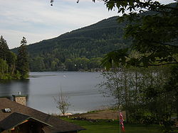
Lake McMurray, Washington
Lake McMurray, Washington | |
|---|---|
 | |
 Location of Lake McMurray, Washington | |
| Country | United States |
| State | Washington |
| County | Skagit |
| Area | |
| • Total | 1.0 sq mi (2.7 km2) |
| • Land | 0.8 sq mi (2.1 km2) |
| • Water | 0.2 sq mi (0.5 km2) |
| Population (2010) | |
| • Total | 192 |
| • Density | 242.5/sq mi (93.6/km2) |
| Time zone | UTC-8 (Pacific (PST)) |
| • Summer (DST) | UTC-7 (PDT) |
| FIPS code | 53-37526Template:GR |
Lake McMurray is a census-designated place (CDP) in Skagit County, Washington, United States. The population was 192 at the 2010 census. It is included in the Mount Vernon–Anacortes, Washington Metropolitan Statistical Area.
Based on per capita income, Lake McMurray ranks 43rd of 522 ranked areas in the state of Washington. It is part of the Conway School District.
History
Sited in then-virgin forest and following the 'if you build it, they will come' ethos predominant in 19th Century Western American development, the town of McMurray was platted by a Dr. Marcus Kenyon in 1890 beside right-of-way of the newly constructed Seattle & Lake Shore Railway. It grew around the Atlas lumber mill which harvested the massive fir and cedar trees which dominated the landscape and was incorporated as a town in 1910. At its peak, the community rarely reached a population of 400 people despite the mill works and businesses that served the population. The inhabitants voted to dis-incorporate in 1923 due to difficulty in raising sufficient taxes to finance town operations following the demise of the town's main source of revenue, the lumber mill. The railroad tracks, by that time a branch of the Northern Pacific RR, were pulled up in 1973. The community then fell into a long, comfortable and quiet existence as an area of senic home sites around a lake known for trout & bass fishing.
Education
Lake McMurray is part of the Conway School District.
Geography
Lake McMurray is located at 48°18′50″N 122°13′49″W / 48.31389°N 122.23028°W (48.313850, -122.230144).Template:GR
According to the United States Census Bureau, the CDP has a total area of 1.0 square miles (2.7 km²), of which, 0.8 square miles (2.1 km²) of it is land and 0.2 square miles (0.5 km²) of it (19.42%) is water.
Demographics
As of the censusTemplate:GR of 2000, there were 200 people, 83 households, and 62 families residing in the CDP. The population density was 242.5 people per square mile (94.2/km²). There were 104 housing units at an average density of 126.1/sq mi (49.0/km²). The racial makeup of the CDP was 90.00% White, 0.50% African American, 3.50% Asian, 2.00% Pacific Islander, 0.50% from other races, and 3.50% from two or more races. Hispanic or Latino of any race were 0.50% of the population.
There were 83 households out of which 31.3% had children under the age of 18 living with them, 65.1% were married couples living together, 4.8% had a female householder with no husband present, and 25.3% were non-families. 22.9% of all households were made up of individuals and 12.0% had someone living alone who was 65 years of age or older. The average household size was 2.41 and the average family size was 2.79.
In the CDP the age distribution of the population shows 20.5% under the age of 18, 5.5% from 18 to 24, 24.5% from 25 to 44, 33.5% from 45 to 64, and 16.0% who were 65 years of age or older. The median age was 44 years. For every 100 females there were 124.7 males. For every 100 females age 18 and over, there were 114.9 males.
The median income for a household in the CDP was $65,536, and the median income for a family was $62,083. Males had a median income of $36,071 versus $39,375 for females. The per capita income for the CDP was $29,051. None of the population or families were below the poverty line.
Major roads
References

