
Lashio
Lashio
လားရှိုးမြို့ | |
|---|---|
Town | |
 | |
 Lashio Location in Myanmar (Burma) | |
| Coordinates: 22°56′N 97°45′E / 22.933°N 97.750°E | |
| Country | |
| State | |
| District | Lashio District |
| Township | Lashio Township |
| Elevation | 2,746 ft (836 m) |
| Population (2009 estimate) | |
| • Total | 131,000 |
| • Religions | Buddhism |
| Time zone | UTC+6.30 (MMT) |
Lashio (Burmese: လားရှိုးမြို့; MLCTS: la: hrui: mrui., IPA: [láʃó mjo̰]; Shan: လႃႈသဵဝ်ႈ) is the largest town in northern Shan State, Myanmar, about 200 kilometres (120 mi) north-east of Mandalay. It is situated on a low mountain spur overlooking the valley of the Yaw River.[1] Loi Leng, the highest mountain of the Shan Hills, is located 45 km (28 mi) to the south-east of Lashio.[2]
Lashio is the administrative center of Lashio Township and Lashio District; before April 2010, it was also the administrative center of Shan State (North). The population grew from approximately 5000 in 1960 to 88,590 in 1983. It is currently estimated at approximately 130,000.[3]
The population is made up of mostly Shan, Chinese and Burmans.
History
The British colonial period in this part of the country began in 1887, and the Myanmar Railways line from Mandalay reached Lashio in 1903.
Before British rule Lashio was also the centre of authority for the northern Shan States, but the Burmese post in the valley was close to the Nam Yao, in an old Chinese fortified camp. The Lashio valley was formerly very populous; but a rebellion, started by the sawbwa of Hsenwi, about ten years before the British occupation, ruined it.[1]
In 1900, the town of Lashio consisted of the European station, with court house and quarters for the civil officers; the military police post, the headquarters of the Lashio battalion of military police; and the native station, in which the various nationalities, Shans, Burmans, Hindus and Muslims, who were divided into separate quarters, with reserves for government servants and for the temporary residences of the five sawbwas of the northern Shan States; and a bazaar.[1]
Lashio became important during the Sino-Japanese War resp. World War II as the Burmese terminus of the Burma Road 1938-45. In World War II, Lashio was taken by the Japanese April 29, 1942 and liberated by the Allies March 7, 1945.[4]
Climate
Lashio has a humid subtropical climate (Cwa) according to the Köppen climate classification system, marked by heavy rains from May to October. The annual rainfall averages 54 inches (1,400 mm). The average maximum temperature is 27 °C (81 °F) and the average minimum 13 °C (55 °F) .[1][5] Temperatures are generally warm throughout the year, though nights are cool from December to March.
| Climate data for Lashio (1981–2010) | |||||||||||||
|---|---|---|---|---|---|---|---|---|---|---|---|---|---|
| Month | Jan | Feb | Mar | Apr | May | Jun | Jul | Aug | Sep | Oct | Nov | Dec | Year |
| Record high °C (°F) | 38.9 (102.0) |
33.5 (92.3) |
36.5 (97.7) |
38.0 (100.4) |
38.1 (100.6) |
37.0 (98.6) |
34.6 (94.3) |
36.0 (96.8) |
35.6 (96.1) |
34.4 (93.9) |
32.4 (90.3) |
30.5 (86.9) |
38.9 (102.0) |
| Mean daily maximum °C (°F) | 25.7 (78.3) |
28.1 (82.6) |
31.2 (88.2) |
32.8 (91.0) |
31.6 (88.9) |
30.7 (87.3) |
29.3 (84.7) |
29.6 (85.3) |
29.9 (85.8) |
29.3 (84.7) |
27.1 (80.8) |
25.2 (77.4) |
29.2 (84.6) |
| Mean daily minimum °C (°F) | 5.2 (41.4) |
6.1 (43.0) |
9.6 (49.3) |
15.1 (59.2) |
19.2 (66.6) |
21.8 (71.2) |
21.9 (71.4) |
21.8 (71.2) |
20.9 (69.6) |
18.7 (65.7) |
13.3 (55.9) |
8.1 (46.6) |
15.1 (59.2) |
| Record low °C (°F) | −1.9 (28.6) |
1.0 (33.8) |
3.0 (37.4) |
8.0 (46.4) |
12.5 (54.5) |
18.4 (65.1) |
20.1 (68.2) |
20.0 (68.0) |
16.9 (62.4) |
8.3 (46.9) |
6.0 (42.8) |
1.0 (33.8) |
−1.9 (28.6) |
| Average rainfall mm (inches) | 2.7 (0.11) |
5.9 (0.23) |
9.6 (0.38) |
57.1 (2.25) |
171.9 (6.77) |
178.3 (7.02) |
213.0 (8.39) |
290.9 (11.45) |
280.7 (11.05) |
175.6 (6.91) |
75.5 (2.97) |
10.0 (0.39) |
1,471.2 (57.92) |
| Source: Norwegian Meteorological Institute[6] | |||||||||||||
Landmarks
- Yan Tine Aung Pagoda
- Chinese Temple
- Natural Hot spring
- Sarsana Hill
- Mansu Shan Monastery
- Lashio Night Bazaar
- Hu Mon Dam
- Linnoet (bat) cave
- Ye Kan Thaung
Transport
Lashio is located at the end of the Burma Road, and at the terminus of the Mandalay-Kunlong railway. It is also the end point of the government cart road from Mandalay, from which it is 178 miles (286 km) distant.[1]
The scenic Goteik viaduct is near Lashio and trains travelling from Mandalay pass over the bridge, which is the highest bridge in Myanmar.
In 2009, a railway link through to Jiegao in China was proposed. In 2011 the proposal was expanded to a link between Kunming and Kyaukphyu. President Thein Sein’s signed a memorandum of understanding during his May 2011 visit to Beijing between Myanmar’s rail transport ministry and China’s state-owned Railway Engineering Corporation to build the railway.[7]
It is the home of Lashio Airport.
Culture
Religious sites include the Sasana (Pyilon Chanta) Pagoda and the Mansu Pagoda. Yepusan spa is nearly five miles away from the city center, and is healthful in winter. Other than some ethnic minorities group, Lashio is also a town with a heavy Chinese population. The most famous Chinese temples in the area are 观音山,灵峰寺 where most Chinese people attend every year during the Chinese New Year (Spring Festival). Since 2000, Lashio has been important for border trade between Myanmar and China. [citation needed]. It is 190 kilometres (120 mi) from Muse, and is situated midway between Muse and Mandalay.
Sai Mauk Kham, one of the Vice Presidents of Myanmar's democratic government from the 2010 general election, was elected from Lashio constituency.
Education
The town is home to the Lashio University, the Computer University (Lashio),[8] the Technology University (Lashio),[9] the Education College (Lashio) and the Lashio Nursing School.
Gallery
-
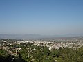 Lashio skyline
 -
 Guanyin Temple (臘戌觀音寺)
 -
 Lashio Gate
 -
 Nagayon Pagoda
 -
 Sutaungpyay Pagoda
 -
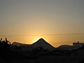 Sunset in Lashio
 -
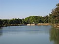 Lake in Lashio


See also
References
- ^ a b c d e Chisholm, Hugh, ed. (1911). . Encyclopædia Britannica. Vol. 16 (11th ed.). Cambridge University Press. p. 233.
- ^ "Loi Leng". Peakbagger.com. 2004-11-01. Retrieved 2014-02-25.
- ^ "Population of Lashio, Myanmar". Population.mongabay.com. Archived from the original on 2013-10-12. Retrieved 2014-02-25.
- ^ Ferrie, Jared (2013-05-29). "Buddhist mobs attack Muslim homes in Myanmar, one dead". Reuters. Retrieved 2014-02-25.
- ^ "Maps, Weather, Videos, and Airports for Lashio, Burma". Fallingrain.com. Retrieved 2014-02-25.
- ^ "Myanmar Climate Report" (PDF). Norwegian Meteorological Institute. pp. 23–36. Archived from the original (PDF) on 8 October 2018. Retrieved 28 October 2018.
- ^ Myanmar in China’s Push into the Indian Ocean, Joshy M Paul, March 14, 2016, retrieved 20 January 2017
- ^ https://web.archive.org/web/20051222041929/http://www.geeky.net/geeky.css. Archived from the original on December 22, 2005. Retrieved May 30, 2011.
{{cite web}}: Missing or empty|title=(help) - ^ "Technological University (Lashio) - Lashio District". Most.gov.mm. Archived from the original on 2014-03-01. Retrieved 2014-02-25.
External links
- Taipei American Chamber of Commerce; Topics Magazine, Analysis, November 2012. Myanmar: Southeast Asia's Last Frontier for Investment, BY DAVID DUBYNE
- Lashio, April 28, 1942 - Story of War 'Last Man in to Bat'
22°56′N 97°45′E / 22.933°N 97.750°E Template:Lashio Township

