
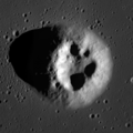
Mairan (crater)
 Lunar Orbiter 4 image | |
| Coordinates | 41°36′N 43°24′W / 41.6°N 43.4°W |
|---|---|
| Diameter | 40 km |
| Depth | 3.4 km |
| Colongitude | 44° at sunrise |
| Eponym | Jean J. d'Ortous de Mairan |

Mairan is a lunar impact crater that is located on a highland peninsula between Oceanus Procellarum to the west and Mare Imbrium to the east. To the north-northeast is the comparably sized crater Sharp. Northwest of Mairan is the heavily eroded Louville.
The outer rim of Mairan has not been significantly eroded or impacted, and retains a sharp edge. The surface around Mairan is rough and irregular, with a multitude of many tiny craters, particularly to the south and west. The inner walls display some terracing, and flow down to a relatively flat interior floor.
Mairan is a crater of Upper (Late) Imbrian age.[1]
Mairan domes[edit]
The volcanic complex, known as Mairan Hills or Mairan Domes, is composed of Mairan T together with three satellite domes (Mairan Northwest, Mairan Middle, and Mairan South). It was formed by two volcanic episodes 3.75±0.1 and 3.35±0.2 billion years ago, extruding a viscous silicic lava simultaneously with basalt eruptions in nearby mare. Most of volcanic complex, except for dome summits, is now buried under mare surface.[2]
In the mare, due west of Mairan, is a small lunar dome designated Mairan T with 3.8 km wide depression at the summit (in official IAU nomenclature "Mairan T" name refers only to the depression), believed to be a caldera[3] The width of hill is about 7 km, and height is about 800 m.[4] It is one of four unusually steep (with slopes reaching 22-27 degrees) and bright domes in area which are thought to be formed by very viscous, high-Si lava.[5]
The composition of domes is changing from the north to south, with Mairan Northwest composed of pyroxenes with 30% quartz admixture, while Mairan South dome composed of nearly pure quartz, with extremely high thorium concentration of 83±19 ppm.[6]
Rima Mairan[edit]
There is a sinuous rille along the southwest edge of the highland peninsula containing Mairan. It is designated Rima Mairan, and follows a north–south course for a length of about 100 kilometers.

Satellite craters[edit]
By convention these features are identified on lunar maps by placing the letter on the side of the crater midpoint that is closest to Mairan.
| Mairan | Latitude | Longitude | Diameter |
|---|---|---|---|
| A | 38.6° N | 38.8° W | 16 km |
| C | 38.6° N | 46.0° W | 7 km |
| D | 40.9° N | 45.4° W | 10 km |
| E | 37.8° N | 37.2° W | 6 km |
| F | 40.3° N | 45.1° W | 9 km |
| G | 40.9° N | 50.8° W | 6 km |
| H | 39.3° N | 40.0° W | 5 km |
| K | 40.8° N | 41.0° W | 6 km |
| L | 39.0° N | 43.2° W | 6 km |
| N | 39.2° N | 45.5° W | 6 km |
| T | 41.7° N | 48.3° W | 3 km |
| Y | 42.7° N | 44.0° W | 7 km |
-
 Lunar dome Mairan T
 -
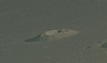 Mairan T from Apollo 15
.png)

References[edit]
- ^ The geologic history of the Moon. USGS Professional Paper 1348. By Don E. Wilhelms, John F. McCauley, and Newell J. Trask. U.S. Government Printing Office, Washington: 1987. Table 11.2.
- ^ Geology of Mairan middle dome: Its implication to silicic volcanism on the Moon
- ^ "Mairan". Gazetteer of Planetary Nomenclature. USGS Astrogeology Research Program.
- ^ Tran, T.; Robinson, M. S.; Lawrence, S. J.; Braden, S. E.; Plescia, J.; Hawke, B. R.; et al. (March 2011). "Morphometry of Lunar Volcanic Domes from LROC" (PDF). 42nd Lunar and Planetary Science Conference, Held March 7–11, 2011 at the Woodlands, Texas. LPI Contribution (1608 p.2228): 2228. Bibcode:2011LPI....42.2228T.
- ^ Lena R.; Wöhler C.; Phillips J.; Chiocchetta M. T. (2013). Lunar Domes: Properties and Formation Processes. Springer Science & Business Media. pp. vii, 5–13, 35, 42. Bibcode:2013ldpf.book.....L. doi:10.1007/978-88-470-2637-7. ISBN 9788847026377.
- ^ The Mairan domes: Silicic volcanic constructs on the Moon
- Andersson, L. E.; Whitaker, E. A. (1982). NASA Catalogue of Lunar Nomenclature (PDF). NASA RP-1097. Archived from the original on 2014-10-06.
{{cite book}}: CS1 maint: bot: original URL status unknown (link) - Blue, Jennifer (July 25, 2007). "Gazetteer of Planetary Nomenclature". USGS. Retrieved 2015-12-31.
- Bussey, B.; Spudis, P. (2004). The Clementine Atlas of the Moon. New York: Cambridge University Press. ISBN 978-0-521-81528-4.
- Cocks, Elijah E.; Cocks, Josiah C. (1995). Who's Who on the Moon: A Biographical Dictionary of Lunar Nomenclature. Tudor Publishers. ISBN 978-0-936389-27-1.
- McDowell, Jonathan (July 15, 2007). "Lunar Nomenclature". Jonathan's Space Report. Retrieved 2007-10-24.
- Menzel, D. H.; Minnaert, M.; Levin, B.; Dollfus, A.; Bell, B. (1971). "Report on Lunar Nomenclature by the Working Group of Commission 17 of the IAU". Space Science Reviews. 12 (2): 136–186. Bibcode:1971SSRv...12..136M. doi:10.1007/BF00171763. S2CID 122125855.
- Moore, Patrick (2001). On the Moon. Sterling Publishing Co. ISBN 978-0-304-35469-6.
- Price, Fred W. (1988). The Moon Observer's Handbook. Cambridge University Press. ISBN 978-0-521-33500-3.
- Rükl, Antonín (1990). Atlas of the Moon. Kalmbach Books. ISBN 978-0-913135-17-4.
- Webb, Rev. T. W. (1962). Celestial Objects for Common Telescopes (6th revised ed.). Dover. ISBN 978-0-486-20917-3.
- Whitaker, Ewen A. (2003). Mapping and Naming the Moon. Cambridge University Press. ISBN 978-0-521-54414-6.
- Wlasuk, Peter T. (2000). Observing the Moon. Springer Science & Business Media. ISBN 978-1-852-33193-1.