Malimono
Appearance
Malimono | |
|---|---|
| Municipality of Malimono | |
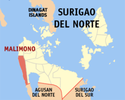
 Map of Surigao del Norte with Malimono highlighted | |
Location within the Philippines | |
| Coordinates: 9°37′06″N 125°24′07″E / 9.6183°N 125.4019°E | |
| Country | |
| Region | Caraga |
| Province | Surigao del Norte |
| District | 2nd District |
| Barangays | 14 (see Barangays) |
| Government | |
| • Type | Sangguniang Bayan |
| • mayor of Malimono[*] | Teodoro Fortich Sinaca Jr. |
| • Electorate | 14,452 voters (2022) |
| Area | |
• Total | 80.13 km2 (30.94 sq mi) |
| Population (2020 census)[3] | |
• Total | 18,852 |
| • Density | 240/km2 (610/sq mi) |
| Time zone | UTC+8 (PST) |
| ZIP code | 8402 |
| PSGC | |
| IDD : area code | +63 (0)86 |
| Income class | 5th municipal income class |
| Revenue (₱) | ₱ 90.49 million (2020) |
| Native languages | Surigaonon Agusan Cebuano Tagalog |
| Website | www |
Malimono, officially the Municipality of Malimono, is a 5th class municipality in the province of Surigao del Norte, Philippines. According to the 2020 census, it has a population of 18,852 people.[3]
Barangays
Malimono is politically subdivided into 14 barangays.
- Bunyasan
- Cagtinae
- Can-aga
- Cansayong
- Cantapoy
- Cayawan
- Doro (Binocaran)
- Hanagdong
- Karihatag
- Masgad
- Pili
- San Isidro (Poblacion)
- Tinago
- Villariza
Demographics
| Year | Pop. | ±% p.a. |
|---|---|---|
| 1960 | 6,537 | — |
| 1970 | 9,412 | +3.71% |
| 1975 | 10,074 | +1.37% |
| 1980 | 12,109 | +3.75% |
| 1990 | 16,208 | +2.96% |
| 1995 | 14,191 | −2.46% |
| 2000 | 14,597 | +0.61% |
| 2007 | 16,883 | +2.03% |
| 2010 | 18,316 | +3.01% |
| 2015 | 18,054 | −0.27% |
| Source: Philippine Statistics Authority[4][5][6][7] | ||
References
- ^ Municipality of Malimono | (DILG)
- ^ "Province: Surigao del Norte". PSGC Interactive. Quezon City, Philippines: Philippine Statistics Authority. Retrieved 12 November 2016.
- ^ a b Census of Population (2020). "Caraga". Total Population by Province, City, Municipality and Barangay. Philippine Statistics Authority. Retrieved 8 July 2021.
- ^ Census of Population (2015). "Caraga". Total Population by Province, City, Municipality and Barangay. Philippine Statistics Authority. Retrieved 20 June 2016.
- ^ Census of Population and Housing (2010). "Caraga" (PDF). Total Population by Province, City, Municipality and Barangay. National Statistics Office. Retrieved 29 June 2016.
- ^ Censuses of Population (1903–2007). "Caraga". Table 1. Population Enumerated in Various Censuses by Province/Highly Urbanized City: 1903 to 2007. National Statistics Office.
- ^ "Province of Surigao del Norte". Municipality Population Data. Local Water Utilities Administration Research Division. Retrieved 17 December 2016.
External links
- Philippine Standard Geographic Code
- Philippine Census Information
- Local Governance Performance Management System

