Meligalas
Appearance
Meligalas
Μελιγαλάς | |
|---|---|
Settlement | |
| Coordinates: 37°13′28″N 21°58′11″E / 37.22444°N 21.96972°E | |
| Country | Greece |
| Administrative region | Peloponnese |
| Regional unit | Messenia |
| Municipality | Oichalia |
| Area | |
| • Municipal unit | 78.2 km2 (30.2 sq mi) |
| Population (2011)[1] | |
| • Municipal unit | 3,385 |
| • Municipal unit density | 43/km2 (110/sq mi) |
| • Community | 1,296 |
| Time zone | UTC+2 (EET) |
| • Summer (DST) | UTC+3 (EEST) |
| Vehicle registration | ΚΜ |
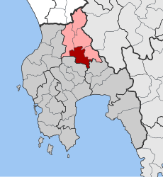
Meligalas (Template:Lang-el) is a town and former municipality in Messenia, Peloponnese, Greece. Since the 2011 local government reform it is part of the municipality Oichalia, of which it is a municipal unit.[2] The municipal unit has an area of 78.193 km2.[3] Population 3,385 (2011).
The town is known for the Battle of Meligalas, which took place on 13–15 September 1944 between the Greek Resistance forces of the Greek People's Liberation Army (ELAS) and the collaborationist Security Battalions. After the battle ELAS forces executed hundreds of Security Battalionists in an event that remains a point of reference and a rallying cry both for the far right and the left in Greece to this day.
References
- ^ "Απογραφή Πληθυσμού - Κατοικιών 2011. ΜΟΝΙΜΟΣ Πληθυσμός" (in Greek). Hellenic Statistical Authority.
- ^ Kallikratis law Greece Ministry of Interior (in Greek)
- ^ "Population & housing census 2001 (incl. area and average elevation)" (PDF) (in Greek). National Statistical Service of Greece. Archived from the original (PDF) on 2015-09-21.


