Mojuí dos Campos
Appearance
Mojuí dos Campos | |
|---|---|
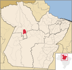
 Location of the Mojuí dos Campos | |
| Country | Brazil |
| Region | Norte |
| State | Pará |
| Emancipated | December 5, 1999 |
| Government | |
| • Mayor | Jailson Alves da Costa (PSDB) |
| Population (2012) | |
• Total | 32,000 |
| [1] | |
Mojuí dos Campos is a municipality in the state of Pará in the Northern region of Brazil. The city had already emancipated from Santarém in 2006, but since that date no municipal elections were run in the city until the 2012 one.[2]
See also
References
- ^ "Mojuí dos Campos, município do oeste do Pará, tem a primeira eleição" (in Portuguese). G1. 8 October 2012. Retrieved 11 January 2013.
- ^ "TRE suspende eleições de Mojuí dos Campos".
2°41′5″S 54°38′25″W / 2.68472°S 54.64028°W

