
Monte Civrari
| Monte Civrari | |
|---|---|
| Punta Imperatoria | |
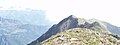
 The summit of Monte Civrari (Punta Imperatoria) | |
| Highest point | |
| Elevation | 2,302 m (7,552 ft) |
| Prominence | 414 m (1,358 ft) |
| Isolation | 4.26 km (2.65 mi) |
| Listing | Alpine mountains 2000-2499 m |
| Coordinates | 45°11′31″N 7°19′39″E / 45.1920614°N 07.3275036°E |
| Geography | |
 Monte Civrari Location in the Alps | |
| Location | Province of Turin, Italy |
| Parent range | Graian Alps |
| Climbing | |
| Easiest route | Hiking from Colle del Colombardo or Niquidetto |
The Monte Civrari is a mountain of the Graian Alps, with an elevation of 2,302 m.[1]
Etymology[edit]
The name Civrari means goats’ mountain (from ciavra, the Piedmontese word for goat).[2] There is strong evidence that the area was in the past widely exploited for goat grazing.[3]
Geography[edit]

The Civrari is not an isolated peak but a small massif. Its main summit is named Punta Imperatoria; in the massif are also located Torretta del Prete (2.264 m), Punta della Croce (2.236 m), Monte Rognoso (1.952 m) and, in a wider sense, also the Punte di Costafiorita and Punta Sourela (1.777 m). On the summit of Punta Imperatoria stands a trigpoint of the IGM named Monte Civrari (code 055037).[4]
Punta Imperatoria is located slightly N of the ridge dividing Val Susa from Val di Viù, and stands on the border between the comunes of Viù and Lemie (both in the Metropolitan City of Turin).
SOIUSA classification[edit]
According to the SOIUSA (International Standardized Mountain Subdivision of the Alps) the mountain can be classified in the following way:[5]
- main part = Western Alps
- major sector = North Western Alps
- section = Graian Alps
- subsection = Southern Graian Alps
- supergroup = catena Rocciamelone-Charbonel
- group = gruppo del Rocciamelone
- subgroup = cresta Lunella-Arpone
- code = I/B-7.I-A.2.b
Access to the summit[edit]
The easiest route for the summit is a footpath starting from Niquidetto or from the Colle del Colombardo, a mountain pass which connects Viù and Condove and can be reached with 4wd vehicles.
Maps[edit]
- Italian official cartography (Istituto Geografico Militare - IGM); on-line version: www.pcn.minambiente.it
- I.G.C. (Istituto Geografico Centrale): Carta dei sentieri e dei rifugi 1:50.000 scale n.2 Valli di Lanzo e Moncenisio, and 1:25.000 scale n.110 Basse valli di Lanzo
Bibliography[edit]
- Alpi Graie meridionali, Giulio Berutto e Lino Fornelli, Guida dei Monti d'Italia; Club Alpino Italiano, 1980
Notes[edit]
- ^ Geoportale IGM on www.pcn.minambiente.it
- ^ Gallenga, Antonio Napoleone (1856). Storia del Piemonte dai primi tempi alla Pace di Parigi (in Italian). Vol. 1. Eredi Botta editore. p. 11.
- ^ Clavarino, Luigi (1867). Saggio di corografia: statistica e storica delle Valli di Lanzo (in Italian). Stamperia della Gazzetta del popolo. p. 133.
- ^ Punti Geodetici, IGM, on www.igmi.org Archived June 5, 2012, at the Wayback Machine (consultato nel marzo 2011)
- ^ Marazzi, Sergio (2005). Atlante Orografico delle Alpi. SOIUSA (in Italian). Priuli & Verlucca. p. 134. ISBN 978-88-8068-273-8.
Image gallery[edit]
-
 Torretta del Prete
 -
 Punta della Croce
 -
 Monte Rognoso
 -
 Punta Sourela summit
.jpg)


External links[edit]
- Monte Civrari: 360° panoramic image from the summit on pano.ica-net.it
- Monte Civrari-Punta Imperatoria, Italy on peakbagger.com
See also[edit]
![]() Media related to Monte Civrari at Wikimedia Commons
Media related to Monte Civrari at Wikimedia Commons